September 10: The climatological peak of the Atlantic hurricane season
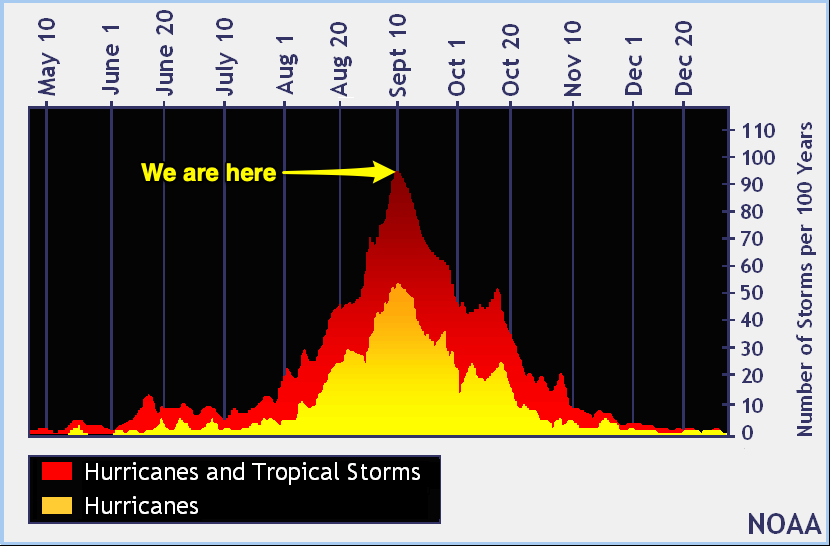
Today is September 10, which marks the climatological peak of hurricane season in the Atlantic basin. Fresh off our brush with Dorian, let’s take a look at where we are and where we might be headed for the rest of the season, which runs through November 30.
Where we’ve been

Back in August, both NOAA and Colorado State University revised their seasonal predictions up a bit, accounting for a weakening El Nino to remove some inhibition to tropical development.
The season had been largely quiet through the end of August. After Subtropical Storm Andrea in May and Hurricane Barry in July, Tropical Storm Chantal formed on August 20 well in the North Atlantic after having scraped the Carolinas as a disturbance spun up along a cold front earlier in the month.
Then Dorian got started as a tropical storm. It may have been aided in some of its northward progression by the short-lived Tropical Storm Erin, which likely created a weakness in the subtropical ridge that allowed for Dorian to line up with the Bahamas for its catastrophic hit on the Abaco Islands as a Category 5 monster, becoming the second-strongest storm by pressure in the Atlantic basin in the process. (Here’s how you can donate directly to the Bahamas for relief efforts.)
While Dorian raged, Tropical Storm Fernand formed in the Gulf and promptly made landfall in Mexico. Then, Tropical Storm Gabrielle formed; as of this writing, it continues to spin around harmlessly in the north Atlantic as a weak system.
The next named storm would be Humberto.

Tropical weather outlook for the next five days

The National Hurricane Center is watching three areas in the Atlantic for potential tropical development.
Disturbance 1, situated 900 miles east of the Lesser Antilles, has a 20% chance of development into a tropical cyclone as it heads eastward over the next few days. NHC expects that increasingly hostile wind shear will keep it from any meaningful tropical development as it presses further east.
Disturbance 2, situated southeast of the Bahamas, has a 30% chance of development once it gets into the Gulf of Mexico. This disturbance will help enhance rainfall as far north as our neck of the woods. What it does in the Gulf, if anything, is still an open question, but as of now it does not pose an immediate threat to the United States as a tropical cyclone.
Disturbance 3, coming off the coast of Africa, has a small chance of developing into a tropical system in the next five days as it moves into more favorable conditions roughly around where Disturbance 1 is right now.
None of these systems pose an imminent threat to the United States.
Will we see another storm this year?
It’s impossible to say for certain if we will see another tropical system this year. As we saw with Dorian, things can change on a dime, and it’s always important for us at the coast to be keeping an eye on the tropics, especially this time of year.
We have a few tools in the toolbox, though, to help us sniff out the overall pattern. This can give us an idea of what to expect over time. Nothing here is exact!
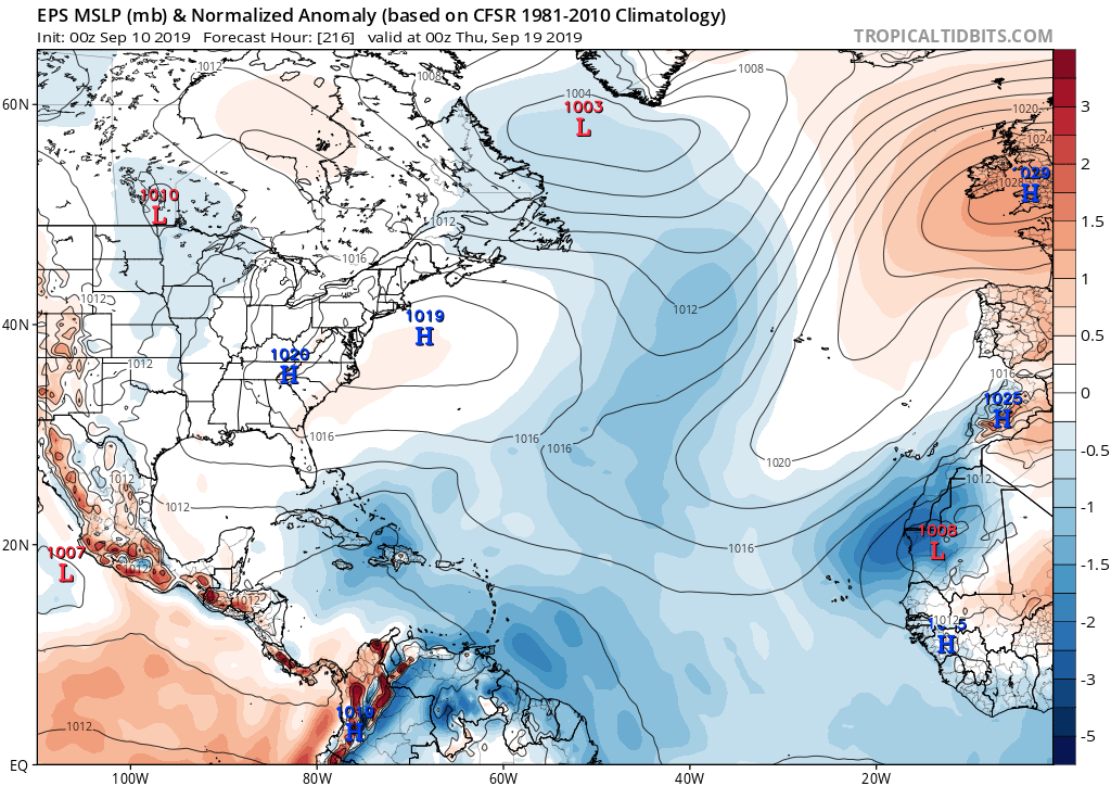
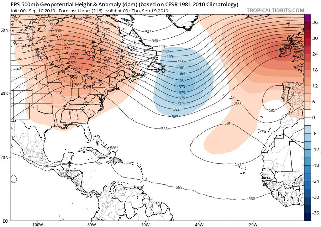
Some of the ensemble runs from the European model suggest lower pressures in the main development region of the Atlantic with ridging building over the eastern US. This can indicate two things:
- Generally active weather in the tropics — not necessarily hurricanes, but disturbances making their way eastward
- A steering pattern favorable to bringing storms close to the East Coast, especially for storms that make it generally west of 60° W longitude
There is agreement for this general pattern in the GFS ensembles (GEFS) that we run here in the good ol’ U.S. of A., but the EPS is generally regarded as a better tool in the toolbox because of the overall skill of the model coupled with the number of ensemble members it takes into account (51 runs for the EPS vs. 21 for the GEFS).
Again, it’s extremely important to note that there are no active tropical threats to the United States. These ensemble runs don’t pick out any one particular disturbance as a threat, either. What they do, however, is give us an idea of what the pattern is like so meteorologists know what to watch for as they consider more detailed forecast questions around specific tropical systems. What these ensemble runs tell us right now is that we shouldn’t let our guard down just yet.
But what about these hurricane snacks?
As long as they are non-perishable, keep ’em. Same goes for sandbags and other things you may have acquired to prepare for Dorian — they don’t expire! Thanks to Dorian, you’re now well ahead of the curve in case another storm decides to threaten us down the line. Hopefully you won’t need them, but if you do, it’s a lot less running around in a highly stressful situation.
Bottom line
- Tropical season is not over yet; we still have several historically active weeks to go. Keep your kit up to date and check in with the tropical outlook occasionally.
- The surface pressure and upper-air pattern seems to favor additional storm development. Steering looks to be configured in a way where another storm may threaten the United States later this season, but this is far from certain.
- There are no imminent threats to the United States coastline.
- See bullet #3.
- If it becomes time to watch and potentially act on a specific tropical threat, local meteorologists will have you covered. Until then, it’s just best to live your life 🙂
Follow my Charleston Weather updates on Mastodon, Bluesky, Instagram, Facebook, or directly in a feed reader. Do you like what you see here? Please consider supporting my independent, hype-averse weather journalism and become a supporter on Patreon for a broader look at all things #chswx!