Tropical update: Another depression looking likely near the Bahamas

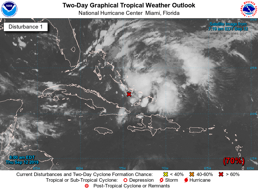
The National Hurricane Center is watching an area of disturbed weather affecting the Bahamas for potential tropical cyclone development. This wave has been watched closely for the last few days, and probabilities for development have been rising. It now appears likely that we will see a tropical depression form in the next couple days. If it becomes named, it would be named Humberto.
Beware of Scary Model Runs
Seemingly on cue, there are no shortage of scary model runs floating around, including one (yes, that Euro run everyone is talking about) that develops the storm into a hurricane off the east coast of Florida over the weekend. We will need to see a lot more run-to-run consistency as well as agreement in the guidance members before there is any confidence in any one solution; the Euro just now picked up on this with the overnight run. We will see what it has to say today as more observations are taken. A Hurricane Hunter flight is scheduled into the storm this afternoon, according to NHC, and that should help get some better data into the models so that they can initialize better.
Often time, with these disorganized waves, the models have a really, really tough time initializing them, which can taint the subsequent solution. Dorian is an excellent example of this; the models consistently took the storm over Hispaniola, keeping it much weaker, before an unforecasted reformation of the center to the north. (We know what happened next.)
I know anxieties are running quite high in the wake of Dorian (and rightfully so). I urge you to monitor official forecasts for your decision-making. There is such a wide spread of possibilities ranging from an open wave moving into the Gulf to a hurricane recurving well off the coast. Model runs show us a series of possible solutions, which are then synthesized into a forecast of what is most likely to happen. Stick with those end-products, rather than the raw materials.
What to do today
- Monitor forecast updates from the National Hurricane Center as well as the local office in Charleston.
- Avoid the temptation to look at weather models. The Hurricane Hunter flights, as well as any additional recon flights ahead of the storm, will gather much-needed data to make these models more accurate. Consider them highly volatile at this stage, and likely less reflective of reality than they normally would be.
- Don’t panic. We have some time to watch this. Plus, I bet your hurricane kits are in much better shape post-Dorian than they were before. Remember, if and when it becomes “go-time,” your local meteorologists and emergency managers will let you know. Until then, just keep an eye on things.
Follow my Charleston Weather updates on Mastodon, Bluesky, Instagram, Facebook, or directly in a feed reader. Do you like what you see here? Please consider supporting my independent, hype-averse weather journalism and become a supporter on Patreon for a broader look at all things #chswx!