A nice weekend concludes; much-needed rain coming next week

Sunday will finish with a little more warmth than we’ve had the last couple days as high pressure slips offshore and a front stalls out nearby. Clouds will be on the increase throughout the day, but rainfall is expected to hold off until overnight. Highs will top out in the mid-80s; with dewpoints in the 60s, this will feel a little warmer and more humid than we felt on Saturday.
Coastal flooding with times of high tide
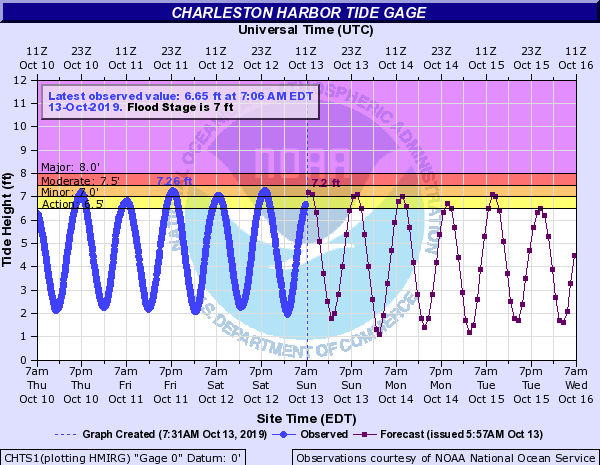
Minor salt water flooding will be possible with the 8:13am and 8:39pm high tides. This will have greatest impacts around the Citadel, particularly the intersection of Hagood Ave. and Fishburne St., which is usually the first thing to flood as tides approach 7′. Some salt water will come up through the drains at the City Market, but major impacts are not anticipated.
Much-needed rain inbound to start the work week

We look to get some much-needed rainfall early this week as an unsettled pattern takes hold as a front stalls out just to our north today. This front will linger for a couple days, acting as a focus for shower and maybe even thunderstorm development starting tonight and lasting into Wednesday. Another front is projected to swing through from the west late Wednesday into early Thursday; said front will usher in below-normal temperatures (low 50s for lows, low 70s for highs) to close out the work week. Get those sweaters ready!
I’ll have a more detailed look at the week ahead later tonight.
Follow my Charleston Weather updates on Mastodon, Bluesky, Instagram, Facebook, or directly in a feed reader. Do you like what you see here? Please consider supporting my independent, hype-averse weather journalism and become a supporter on Patreon for a broader look at all things #chswx!