An increasingly unsettled weekend looms thanks to the tropics

It’s hard to believe that after the coolest morning since April 27, we are talking about the potential for a little tropical mischief in the Gulf. But, it’s still hurricane season, and this one has a shot at bringing us some much-needed rain over the weekend.
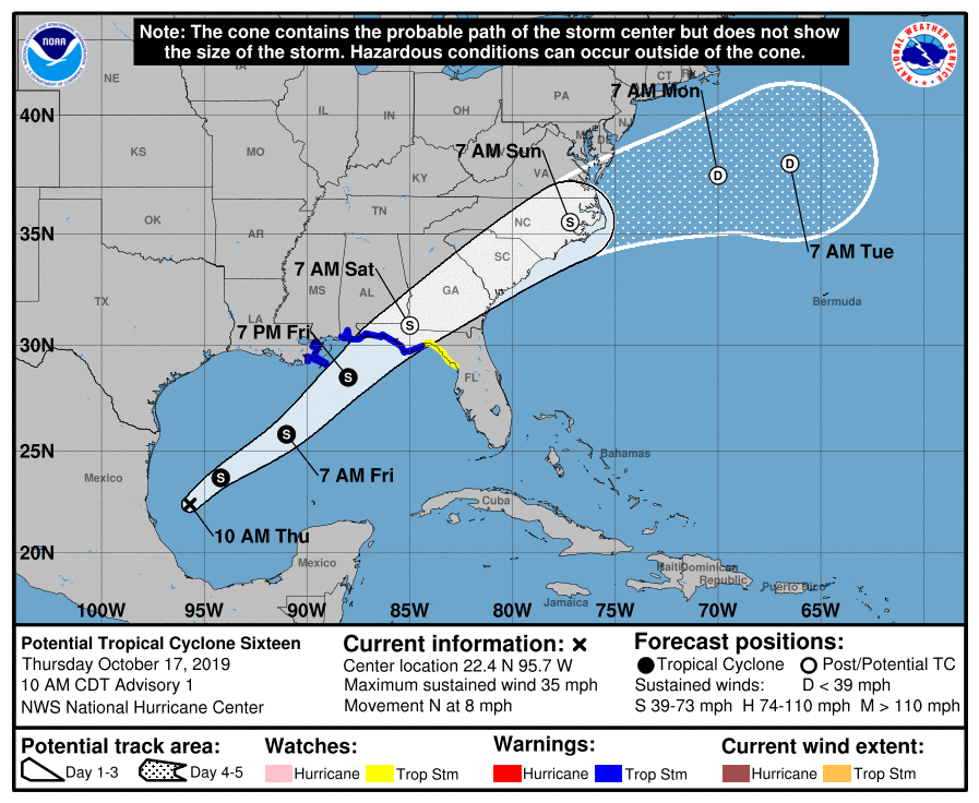
Potential Tropical Cyclone Sixteen — not yet a tropical cyclone, but one that has a high likelihood of developing into one — is in the Gulf of Mexico early this afternoon. It is expected to become a tropical cyclone — perhaps Tropical Storm Nestor — by tonight, and accelerate rapidly to the northeast as it gets steered between a ridge of high pressure aloft over Cuba and a branch of the jet stream over the mid-South.
Whatever this storm ends up developing into from a meteorological standpoint, it will bring a heavy rain, wind, and surge threat to the Florida and AL Gulf Coasts by tomorrow evening.
Impacts for the weekend
The NHC forecast calls for a quick transition of would-be-Nestor to a post-tropical cyclone shortly after landfall early Saturday. Regardless of how the storm is structured, a near-certainty at this point is the potential for beneficial rain on Saturday and early in the day on Sunday. This is going to be a fast-mover, so rain won’t have the residence time needed to cause widespread flooding issues, but we could still see an inch or two over most locations.
To watch: Tidal flooding threat

One thing we’ll need to keep a close eye on with this storm system is the potential for tidal flooding. With the storm’s center passing to our west, onshore flow will drive water levels higher. Probabilistic surge guidance (pictured above) shows a near-certain 7’+ tide midday Saturday. How high this tide gets will be a function of how strong the storm gets and maintains strength. Surge guidance suggests that major coastal flooding is not out of the picture, so we will want to watch that potential closely.
To watch: Tornado threat at the coast
This is going to be a little harder to pin down, but we will want to watch closely for the potential for some rotating thunderstorms at the coast where the best correlation of instability and shear is found. It is early yet, but there is some support for this scenario in both the global and mesoscale models, and as we will be within the eastern semicircle of the landfalling circulation, it is certainly a situation to watch. Gulf landfalls can often drive tropically-driven tornadoes; see Irma as a key example of this.
Bottom line
- Looks like we have a rainy weekend ahead, especially Saturday into early Sunday.
- Tidal flooding is possible midday Saturday.
- There is a small tornado risk at the coast on Saturday, but much uncertainty is to be found.
- There won’t be a major hurricane — no evacuations, no McMaster press conferences, but just a lousy weekend.
Follow my Charleston Weather updates on Mastodon, Bluesky, Instagram, Facebook, or directly in a feed reader. Do you like what you see here? Please consider supporting my independent, hype-averse weather journalism and become a supporter on Patreon for a broader look at all things #chswx!