Warmer and unsettled this week, with a side of tidal flooding

After a rather pleasant weekend, temperatures will begin to trend back above normal this week with chances of showers and perhaps a few thunderstorms each afternoon. Highs will be getting into the mid-80s by midweek, marking a return to that summer preview we were feeling toward the end of March. A cold front will move through the area sometime later this week, bringing a reduction in temperatures, but showers may yet stick around. It’s a fairly low confidence forecast looking toward next weekend with a fair bit of divergence in the models, so stay tuned for updates as things will undoubtedly need to be ironed out.
Coastal flooding possible at times of high tide this week
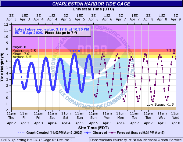
We’ll need to watch for the potential for salt water flooding at times of high tide this week thanks to onshore winds and Tuesday’s full “Super Pink” moon. Impacts to traffic should be minimized with most travel being halted, but those of you working in the hospital district will want to keep an eye on the tides throughout the week for potential salt water complications in that neck of the woods.
Weather notes
- Dr. Phil Klotzbach’s team at Colorado State University has issued its first outlook for the upcoming tropical season, and in true 2020 fashion, it appears we might be in for an above-average hurricane season in the Atlantic basin. A lot will hinge on whether La Niña can develop in the Pacific. Remember, it only takes one storm to make it an active season. The good news is that you don’t have to think about this for a while, yet — hurricane season starts on June 1.
- Tide levels reached 7.17′ in the harbor today, making for the first coastal flood event since February 21, when tide levels reached 7.0′ MLLW. (Remember February?)
- Mariners: The National Weather Service is soliciting feedback on potentially changing the “Small Craft Advisory” to a “Small Craft Warning” as part of the ongoing Hazard Simplification process. If you have a few minutes, take the survey and be heard!
Follow my Charleston Weather updates on Mastodon, Bluesky, Instagram, Facebook, or directly in a feed reader. Do you like what you see here? Please consider supporting my independent, hype-averse weather journalism and become a supporter on Patreon for a broader look at all things #chswx!