Isaias: Wobble wobble wobble

At 8am, Isaias — not the most picturesque hurricane one has ever seen, but a hurricane nonetheless — was making its move on Andros Island in the Bahamas. The storm has been struggling with westerly shear and dry air intrusion, which will keep its intensity capped for now. Today is a pivotal day in the evolution of the storm’s track for the next few days, and we’ll all want to keep an eye on it as we begin to prepare for its arrival Monday.
Track and intensity forecast
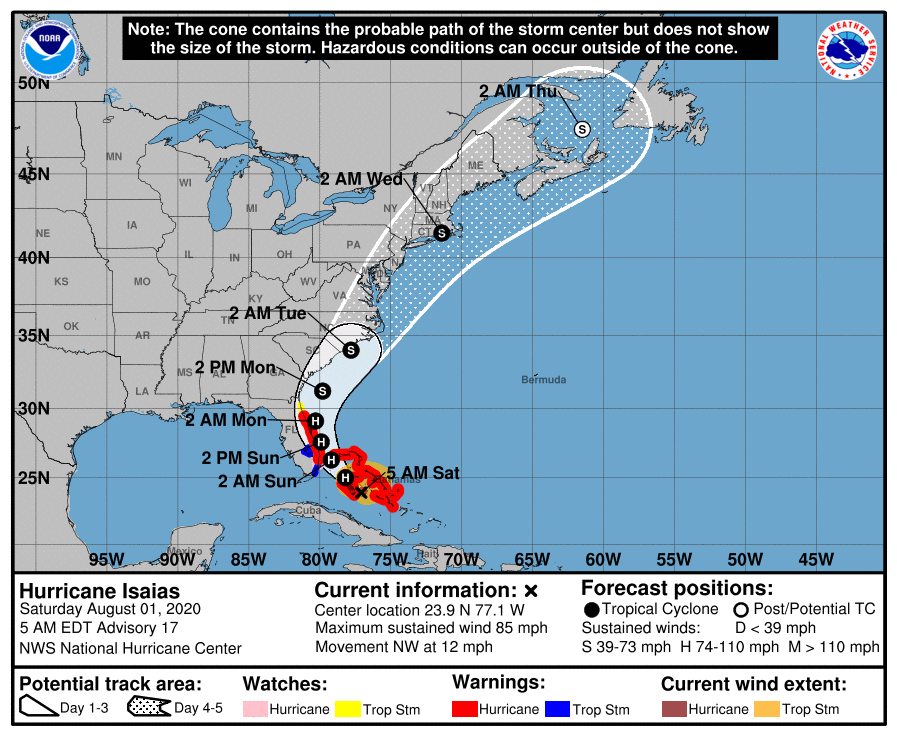
The track and intensity forecast for Isaias is still a bit in flux. A lot depends today on how strong the storm can remain in the face of a little land interaction and persistent westerly wind shear.
Yesterday, we saw a fairly decent shift back westward in the forecast track, bringing the center of a weaker Tropical Storm Isaias within 50 miles or so of Charleston Monday afternoon. This track has since corrected ever-so-slightly east with the overnight model runs (and is also a bit slower), but I would almost certainly expect future adjustments based on what happens today.
Anyone who has been to the beach recently can likely tell you just how warm our waters are, too. It is not out of the realm of possibility that Isaias could strengthen a bit as it heads toward a landfall somewhere between Georgetown and Morehead City, NC late Monday/early Tuesday.
From a preparedness standpoint, I would not get caught up in the minutia of jogs here or there with the forecast track. Tropical storm-force winds, heavy rain, and some tidal flooding are all very much on the table, and we should get ready for those hazards.
Rough timeline for the Lowcountry
First, a disclaimer: These prognostications are still very dependent on what remains an uncertain track and intensity forecast. It could be weaker — or stronger — than what is described below. This is a best effort attempt to outline impacts based on current National Hurricane Center projections and National Weather Service forecasts and is very much subject to change. Hopefully, though, this gives you a general idea of what you can expect and when — again, based on current timing — to expect it.
Now through Monday: Rip currents
One given when any tropical system passes within 200 miles of Charleston is that we will see rough surf and an associated higher risk for rip currents, and Isaias is no exception. NWS has outlined a high risk of rip currents through Monday, making the water a fairly unsafe place to be even for experienced swimmers.
Sunday night through Monday: Coastal flooding, especially around high tide
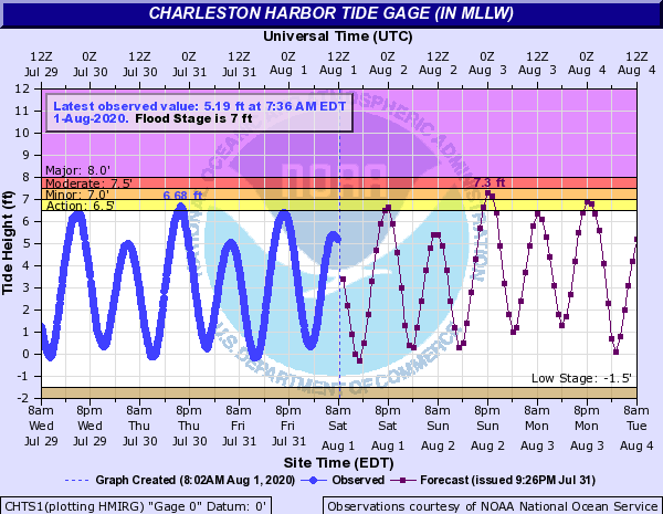
Current water level forecasts indicate the potential for coastal flooding with the evening high tide cycles on Sunday and Monday before Isaias’s center passes north of our latitude, shifting winds offshore and limiting the threat for additional salt water flooding.
The exact impacts of, and how bad, any tidal flooding will be very contingent on how close Isaias gets, how strong it ultimately is, and how well it times itself against times of high and low tide. It’s also worth noting that with a full moon coming up, we were getting into king tides anyway. As a result, it is very possible that the current forecast is too conservative. This will need to be watched closely for adjustments.
Late Sunday/early Monday through Monday night: Heavy rain
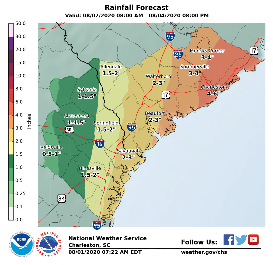
There are a lot of parched yards out there right now. While we are running an overall surplus on rainfall for the year at the airport, more recently we have seen just a few places see appreciable rain, while many lawns crisp up in parts of the Lowcountry, especially along the coast.
The current NWS forecast calls for 3-6″ of rain across the Tri-County area, with the heaviest rain from Charleston up to Moncks Corner and points east. As with almost every other variable here, a track further east could shift the envelope of heavier rain with it (and vice versa).
As we all know very well, heavy rain around times of high tide in particular may enhance coastal flooding/potential storm surge effects. As a result, you should be thinking about where you will put your car if you live in downtown Charleston.
Monday into Monday night: Wind

Based on the latest advisory, the greatest risk for winds to tropical storm-force will be found over the waters and along the immediate coast. The exact track of the center will determine just how far inland tropical storm force-winds can spread. Still, with any heavy rainfall and strong winds, we should be getting ready for at least some sporadic power outages across the area come Monday, especially in coastal communities.
Current expectations are that tropical storm force-winds, if they occur, are most likely to start Monday morning. When winds reach tropical storm-force, it becomes increasingly difficult to carry on any preparations. Bridges do not close, but law enforcement may decide to stay off the bridge until conditions improve when winds hit tropical storm force.
Monday morning into the afternoon: Small risk of tornadoes
Depending on the orientation of Isaias’ track, there is the potential for a few tornadoes ahead of the main circulation on Monday in outer bands. We will need to see how this evolves; a further-east track would keep the tornado threat at bay, whereas a track that’s closer to and a little more perpendicular to the coast will increase the risk of a brief tornado or two. Right now, this is not my biggest concern, but it is something to watch.
Bottom line
As the forecast continues to stabilize, confidence in impacts will generally improve. We will need to keep a close eye on how Isaias evolves over the next couple days to help get confidence up in these impacts.
What to do today
Thanks to the slower motion of the storm, it appears that we have a little more time to get prepared. (If/when tropical storm force winds begin — most likely Monday morning at this point — it’ll be too late.) And while the storm is forecast to be a tropical storm as it approaches SC with its worst weather offshore, it is always good to be prepared a category higher. Tropical cyclone intensity is a fickle beast and very tough to forecast, so it’s better to err on the side of caution than not.
Today, you should:
- Start bringing in loose items. We’ve got a bit of a wind storm coming. It probably won’t be as bad as Matthew or Dorian was (let’s hope!), but loose items outside can still blow around in stronger wind gusts.
- Get ready for the potential for power outages on Monday. As winds come up and squalls move in, sporadic power outages will be possible. (And, if the center gets closer, the power outage potential increases.) Make sure you have batteries for your flashlights and weather radio. If you have charging bricks for your phones, get those juiced up and ready to go in case you lose power for a long period of time.
- Think about where you might put your car if you live in a flood-prone area. I’ve not heard any announcements regarding parking garages yet, but if these open for downtown residents, you’ll want to take advantage.
- Make sure you’re good on masks, hand sanitizer, and other pandemic fare. Yep, COVID-19 doesn’t take a break due to hurricanes. If things take a turn for the worse, you’ll want to make sure you have clean, fresh masks and hand sanitizer in case you need to come into contact with others.
- Monitor forecast updates. There will be continued fine-tuning of the forecast throughout the day. You don’t have to hang on every nook and cranny of every advisory — mental health-wise, that may not be the best idea — but it’s good to stay informed on the latest developments and ensure your preparations are in line with the latest forecast. Do not use weather models to make your decisions. Stick with the official National Hurricane Center forecast.
What’s coming up
- Isaias will move through Andros Island and then approach the east coast of Florida throughout the day.
- The next full track and intensity forecast comes out at 11am. This will be infused with the latest findings from Hurricane Hunter reconnaissance flights, which seem to be finding a somewhat weaker Isaias than was even indicated on the 8am advisory.
- Next global model runs will be out around noon for the GFS and 2-3 PM for the ECMWF.
Follow my Charleston Weather updates on Mastodon, Bluesky, Instagram, Facebook, or directly in a feed reader. Do you like what you see here? Please consider supporting my independent, hype-averse weather journalism and become a supporter on Patreon for a broader look at all things #chswx!