Isaias: Tropical storm warning, storm surge watch, flash flood watch in effect

Impacts from Tropical Storm Isaias are becoming more likely in the Charleston metro area starting tomorrow morning, and additional watches and warnings are now in effect.
Early this morning, the National Hurricane Center upgraded the Tropical Storm Watch to a Tropical Storm Warning across the Tri-County area. A Storm Surge Watch is now in effect for coastal Charleston County, as well. The National Weather Service in Charleston hoisted a Flash Flood Watch for the Tri-County, which goes into effect tomorrow at 8am.
Forecast philosophy relatively unchanged
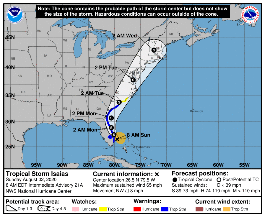
The 5am track from the National Hurricane Center continues to bring Isaias into our neck of the woods starting Monday, with the closest approach sometime Monday night into early Tuesday morning before a forecast landfall around the Grand Strand early Tuesday. Perusing the overnight guidance, a landfall closer to Charleston proper cannot be totally ruled out, which would enhance the rain and wind we would feel.
I cannot stress enough that Isaias is a tricky, lopsided tropical system, and there is significant bust potential here. This forecast assumes a very close center pass to the Tri-County area. Wobbles to the east will lessen our impacts (perhaps substantially); wobbles to the west will serve to maximize them. Be prepared for the higher-end solution, including power outages and flooding, and let’s root for the worst weather to stay offshore.
It’s also worth stressing that this is no Dorian, and this is no Matthew (at least as currently forecast). Every storm is different, though, and will affect you differently. Take heed of all warnings and instructions from emergency management officials.
Flash flood potential
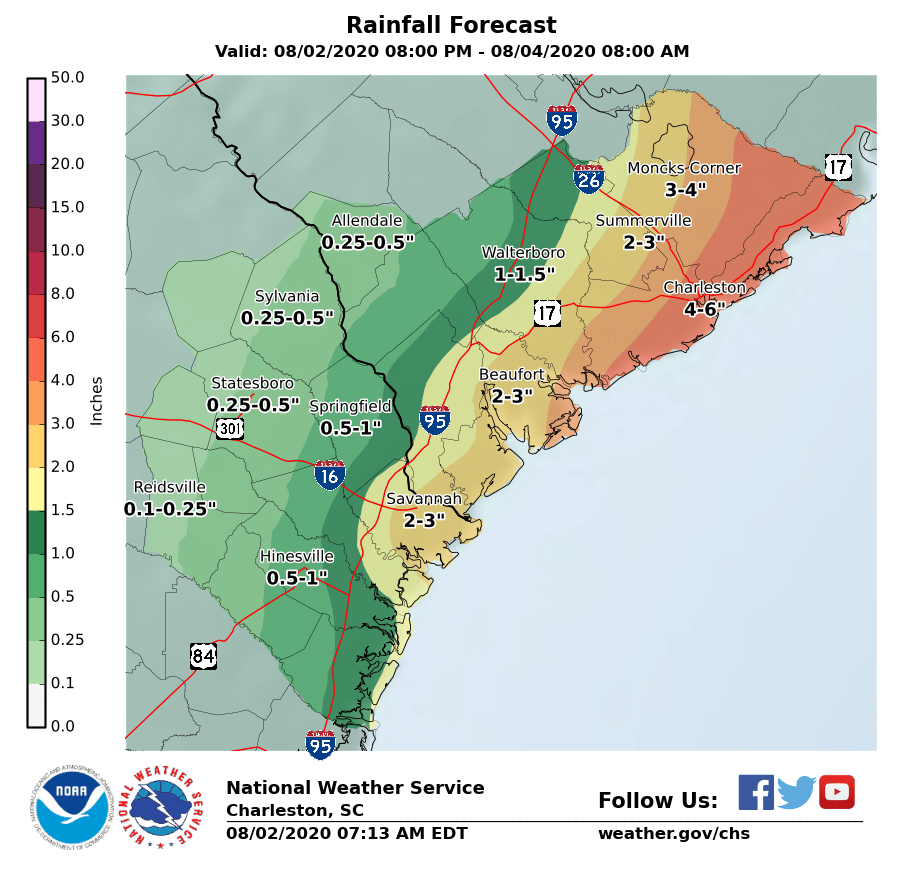
Hydrological hazards are my main concern from Isaias. 4-6″ of rain will be possible across a good swath of Charleston and eastern Berkeley counties, including the Charleston metro area. The rain forecast drops off fairly sharply from there as you head west; depending on how the system is organized and where the center ultimately makes landfall, even the NWS projections of 2-3″ in Summerville may not quite play out.
There is the potential for what is known as a predecessor rain event ahead of Isaias early Monday. This could help enhance rainfall totals inland as well, so we’ll want to watch and see how that develops.
Expect the onset of rain bands by late Monday morning.
Tidal flooding possible as early as tonight’s high tide, with storm surge impacts Monday night
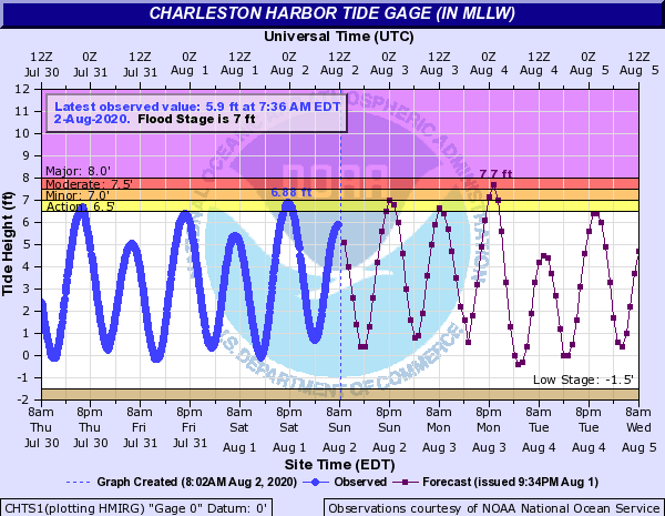
The other main concern is that Isaias is forecast to make its main approach to the Lowcountry very close to when high tide is expected at Charleston Harbor on Monday night (8:59 PM). NWS is currently forecasting a high tide around that time of 7.7′, which would produce moderate coastal flooding across the Charleston area, closing numerous roads on its own. Depending on where the center makes landfall, it is possible that the tide could be driven even higher, into major flood stage (over 8′ MLLW). Add in heavy rain on top of this and you’ve got quite a travel mess. Nobody should be traveling downtown tomorrow evening, as the brunt of Isaias is expected then. A Storm Surge Watch is in effect for the potential for 1-3′ of inundation above ground on Monday.
Tidal flooding will be possible as early as this evening around the 8:19 PM high tide. The current forecast is for a 7′ tide, which would cause some minor issues around Hagood and Fishburne and other low-lying areas in downtown Charleston.
Note: Because a Tropical Storm Warning is in effect, there will be no Coastal Flood Advisories for these tidal flooding events.
Wind impacts
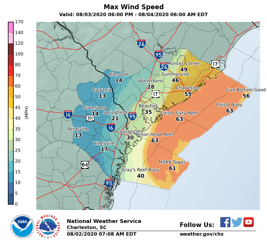

The latest National Weather Service forecast shows maximum sustained winds of tropical storm force generally Monday evening across the eastern half of the Tri-County. The forecast philosophy is simple: Winds will be highest near the coast and calmer the closer to I-95 you are, generally speaking. Again, a lot of the fine details ultimately depend on where the center tracks — a further easterly track will knock down our wind impacts somewhat significantly, while a center pass closer to Charleston proper/further south landfall will bring more wind ashore. Wind gusts could reach 70 MPH in the Charleston metro area and near the coast. Be prepared for power outages lasting several hours — power crews will not be able to restore service until tropical storm force winds die down.
Tornado risk
There will be a risk for isolated tornadoes in Isaias’ outer bands on Monday, generally closest to the coast. It will be interesting to see how much sun can break through and how the storm is oriented with respect to the coast; this will govern the tornado risk some. A track that brings the center in further west would generally increase the tornado risk across the Tri-County area. We’ll want to watch it, but it’s not the top concern.
What to do today
- Finish your preparations for Isaias’ arrival tomorrow. When tropical storm force-winds begin, likely Monday evening, your preparations should be complete and it is time to hunker in for a few hours. Be ready for strong winds causing power outages and potential flooding.
- Keep cell phones charged. If you have power bricks, make sure they’re topped off.
- Bring in loose items from outside. With gusts to 70 MPH possible, you’d be surprised what can become a projectile.
- If you live in a flood-prone part of downtown, get your car to one of the free garages. They are open now and will be through 8am Tuesday. (You’ll be glad you did.)
What’s next
- Full track and intensity update on Isaias comes out at 11am. Forecasts will continue to be fine-tuned with today’s guidance package.
- It is possible the Storm Surge Watch could be upgraded to a Storm Surge Warning later today.