What to expect from Isaias today

Well, Isaias is here and is already raining on us a little bit; I’ve already picked up .72″ from the first round of rain this morning. There’s more where this comes from as Isaias makes its closest pass to Charleston tonight on its way to an expected landfall somewhere between Myrtle Beach and Wilmington.
Isaias is gaining forward speed

Isaias is beginning to gain some forward momentum as it interacts with a trough to the west, which will turn the storm to the north-northeast in parallel with the SC coast later today. As of 8am, maximum sustained winds remained at 70 MPH. The minimum central pressure was 994 millibars, and it is moving northward at 13 MPH.
Isaias’ satellite appearance once again appears somewhat ragged, with the bulk of the convection displaced north and northwest of the center. This will bring us plenty of rain later today.
Primary concern: Water
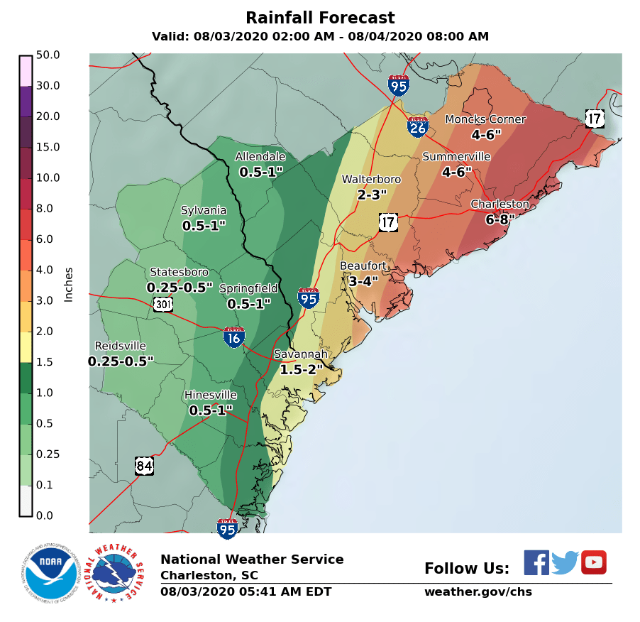
As is often the case with landfalling tropical storms and low-end hurricanes, water is the main cause for concern in the form of rainfall and tidal flooding. Isaias is no exception. The latest NWS rainfall forecast projects 4-6″ across much of the Tri-County area, with 6-8″ of rain possible across the Charleston metro area into the Francis Marion National Forest. The heaviest rain looks to fall later this afternoon into tonight, coincident with the closest pass of the center.
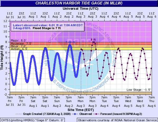
Tidal flooding remains a key concern for tonight. A Storm Surge Warning is in effect for the potential for 2′ of storm surge on top of what would already be a fairly high king tide around 9PM tonight. The current forecast is for the tide to top out around 8′, which on its own would produce significant salt water flooding causing numerous road closures across downtown Charleston as well as on barrier islands. Add in what appears to be the peak of the heavy rain on top of this, and conditions remain primed for a potentially significant flooding event to unfold tonight in downtown Charleston. We will want to watch this carefully today as it evolves, and root for the center to shift north of the area to begin turning the winds offshore.
Winds less of a factor, but still breezy
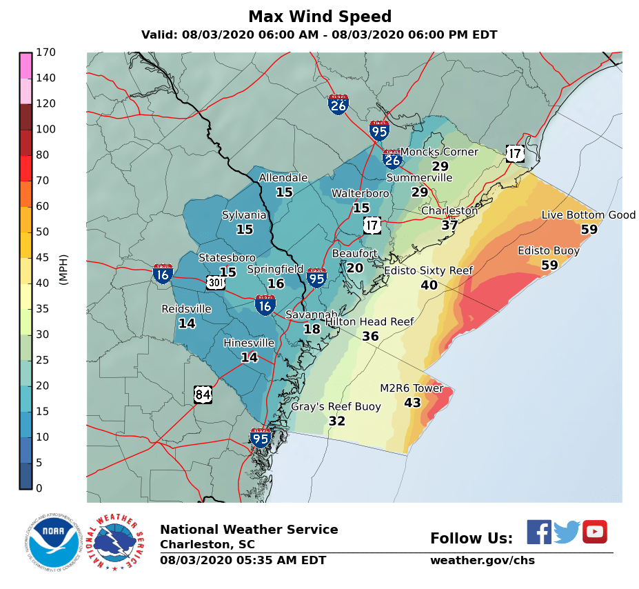


With a general eastward trend in the forecast over the past day, winds look to be somewhat less of a factor across much of the metro area. Expect breezy conditions to pick up later today, with gusty winds within rain bands. The best chance for sustained tropical storm-force winds will be found along the coast and in upper Charleston County; elsewhere, tropical storm-force gusts will be common.
Continue to prepare for the potential for power outages this afternoon and tonight as the strongest winds move in. If enough rainfall occurs prior to the onset of winds, trees will have an easier time falling. However, compared to where we were yesterday, it definitely appears that more widespread power outages are less likely.
Slight tornado risk

Finally, there will be the potential for a short-lived tornado or two as Isaias makes its approach from the south later today into this evening. These are quick to spin up, so be sure to move into tornado shelter quickly if a warning is issued for your area. Tropical tornadoes are typically weaker than what we would see during severe weather season (and there is no indication of a repeat of April 13!), but can still cause localized tree and structural damage.
The best risk for tornadoes will be found east of I-26 and Highway 52 (downtown, beaches, Mt. Pleasant, Huger, Awendaw, McClellanville), but depending on the center’s track, the risk could extend to I-95.
Bottom line
- Water is the main concern. Depending on the track and timing of the center, we could see significant flooding in downtown Charleston. This is not a given, but the potential is there — prepare accordingly.
- Wind is less of a concern, but we could still see low-end tropical storm-force gusts especially along the coast and within rain bands. Sporadic power outages remain possible.
- A tornado or two cannot be ruled out in rain bands later today.
- Back to usual summer heat, humidity, and afternoon storm chances tomorrow.
I’ll have updates on Twitter throughout the day as needed. Stay safe, everyone!
Follow my Charleston Weather updates on Mastodon, Bluesky, Instagram, Facebook, or directly in a feed reader. Do you like what you see here? Please consider supporting my independent, hype-averse weather journalism and become a supporter on Patreon for a broader look at all things #chswx!