Tropical update: Getting busier as the season approaches its peak
It’s been a minute since we’ve needed to take a critical look at the Atlantic here on this site, but that does not mean things have not been busy. Undoubtedly, if you’ve been following the Atlantic season via the National Hurricane Center or other outlets, you are aware of just how active this hurricane season has continued to be. Let’s recap:
- Hurricane Laura making landfall just shy of Category 5 status on Lake Charles, Louisiana, causing significant damage;
- Hurricane Marco, which was fortunately not the initial punch ahead of Laura that forecasters had feared;
- Hurricane Nana, which made landfall in Belize, causing very heavy rainfall, flash flooding, and mudslides;
- Tropical Storm Omar, which spent several days battling wind shear as it meandered harmly out to sea before dissipating
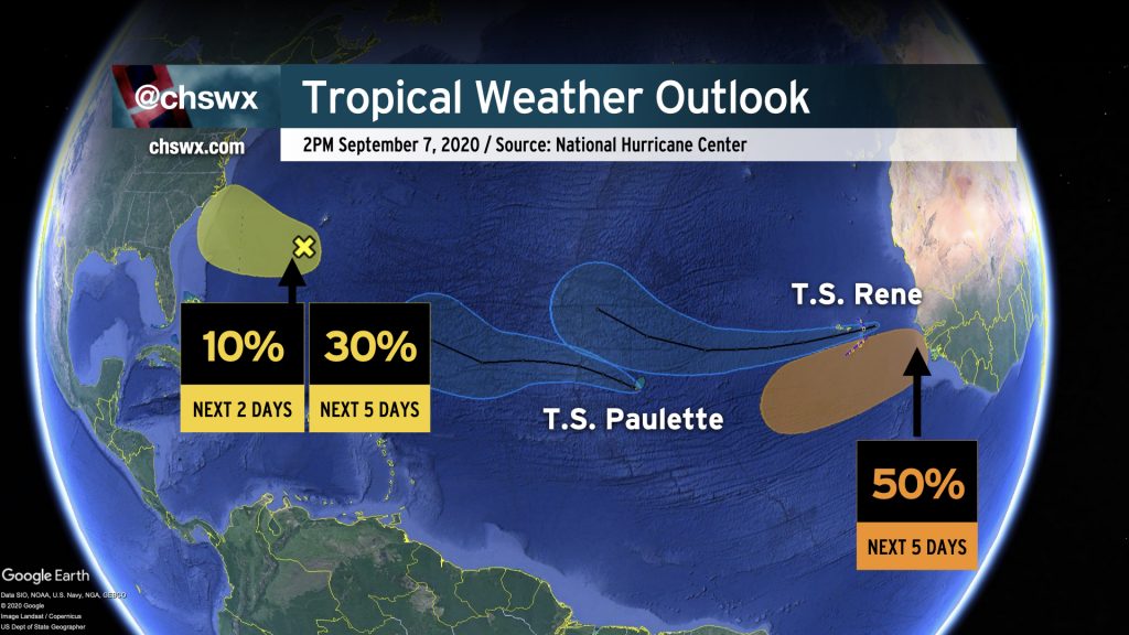
Now, we have Tropical Storm Paulette and Tropical Storm Rene far out in the Atlantic, in addition to two areas being monitored for potential development over the next five days. One of these areas is well off of Africa, but the other is somewhat close to home. We’ll talk about that in a sec.
Names are dwindling
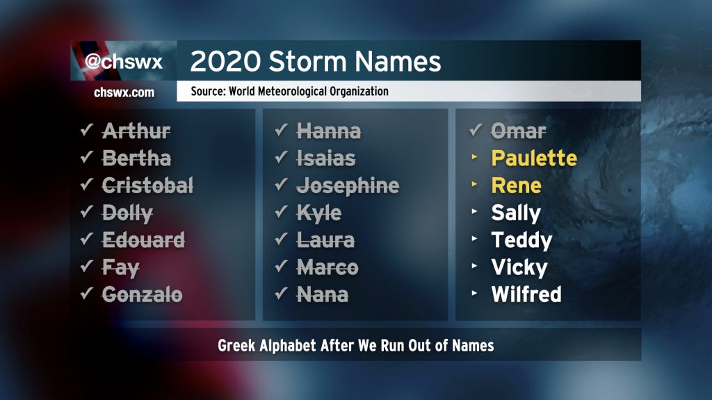
We continue to burn storm names at a record pace. Rene, which was named from Tropical Depression Eighteen this evening, is the earliest “R”-storm on record, beating 2005’s Rita by 11 days.
If this pace continues — and there’s no real sign to say that it will slow down much in the next few weeks — we’ll run out of names for this year’s list. When this happens, the Greek alphabet takes over. In 2005, when 27 storms were named in the Atlantic, we got as far as Zeta.
Swirl of interest near Bermuda the main thing to watch
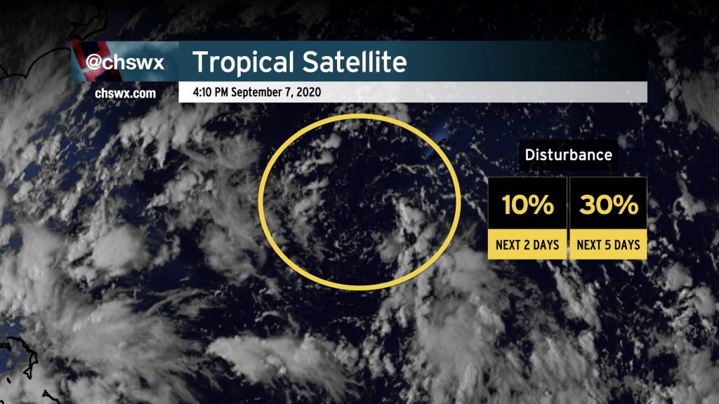
The only area of relative concern to the Southeast US — a long shot, to be fair — is a disorganized swirl south of Bermuda producing showers and thunderstorms. We’ll want to keep an eye on this as it moves closer to the Southeast US this week just to make sure it behaves. There’s not a lot of support for this being much more than a rain-enhancing wave of low pressure in guidance, but sometimes these swirls can surprise as they head over the Gulf Stream. NHC has given this area a 30% chance of development in the next five days.
Paulette and Rene
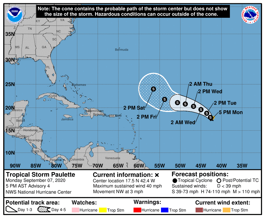
As of 5PM, Paulette was a minimal tropical storm undergoing a fair bit of wind shear moving northwest at 3 MPH, caught in a weakness in the steering currents. Possible interaction with Rene could keep this storm on the weaker side for now, too. NHC forecasts a high to build in to the north of the storm which should turn it more west with time, but in the extended range once again favors a turn to the northwest. No immediate concerns for this one right now, but we’ll watch it as guidance is highly split on its ultimate destination.
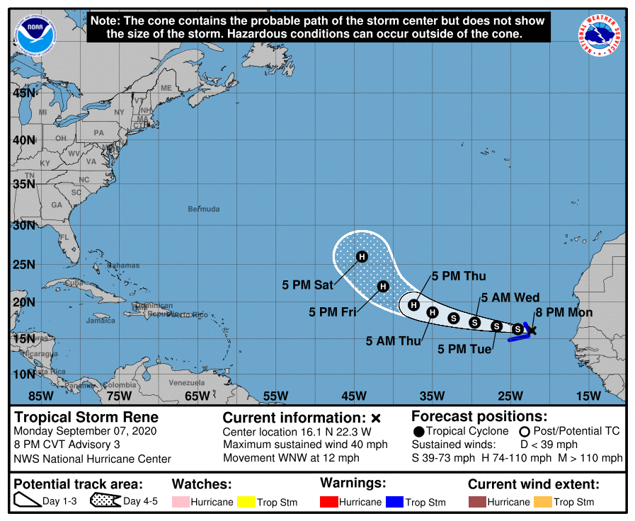
Newly-christened Tropical Storm Rene is bringing rough weather to the Cabo Verde islands this evening as it moves WNW at 12 MPH. It is expected to become a hurricane by Thursday while finding a trough in the central Atlantic to start to turn it more northwest by next weekend. Decent shot this one recurves out of harm’s way, but we’ll keep an eye on it until it does.
Beyond Rene
There’s one more area to watch beyond Rene for later this week into the weekend, and that is a wave over Africa that NHC expects to reach the coast by Wednesday. There’s a 50% chance — pretty decent at this range — that this wave develops into a tropical cyclone by this weekend. Given the relatively low latitude it will be at when it emerges into the Atlantic, this will be one we’ll want to keep an eye on as we get into the second half of September. Very much wait and see, though!
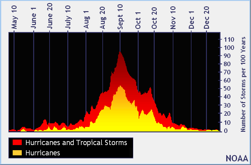
September 10: Peak of the season
September 10 marks the counterpoint of the climatological peak of the Atlantic hurricane season, but there’s plenty of terrain to head down before things tend to calm down in late October. As always, the easiest day to prepare for a storm is a day where there isn’t one in the forecast. It’s always good to periodically check your hurricane supplies, refresh your memory on your evacuation zone, and take a peek at the forecast every once in a while.
Follow my Charleston Weather updates on Mastodon, Bluesky, Instagram, Facebook, or directly in a feed reader. Do you like what you see here? Please consider supporting my independent, hype-averse weather journalism and become a supporter on Patreon for a broader look at all things #chswx!