The week ahead: Off and on rain continues, but temperatures finally abate
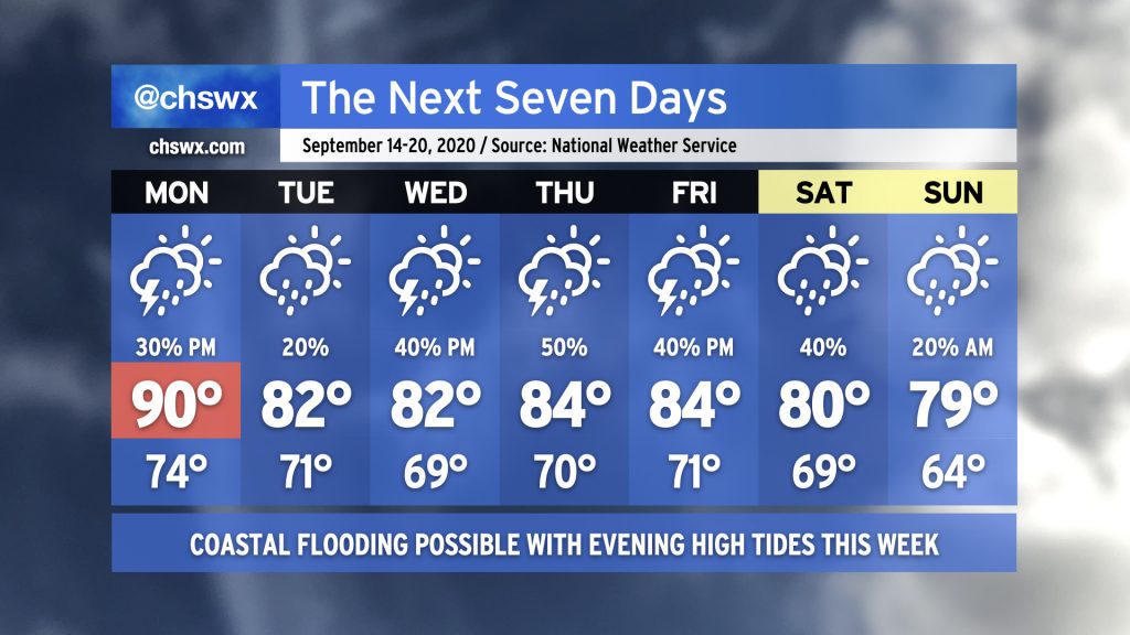
So the first thing you will undoubtedly notice in the seven-day is that it is largely bereft of 90s (save for Monday). You may also notice a high of 79° for Sunday. Yes, that’s out there a ways and could still be tweaked upward, but it is just refreshing to see 70s for highs somewhere in the forecast. We’ll need to deal with some rain and coastal flooding to get here, though.
Backdoor front brings the initial shot of cool air
First, we get through Monday: Scattered showers and thunderstorms will be possible in the afternoon as temperatures head back toward 90° one more time ahead of a backdoor cold front, which may spawn some additional showers as it passes through sometime Monday night. Said front will bring in some cooler, drier air and make Tuesday feel much more pleasant with highs topping out in the low 80s. A few showers will be possible within the wedge of high pressure, but most of us will remain dry.
Sally’s remnants remain a question mark
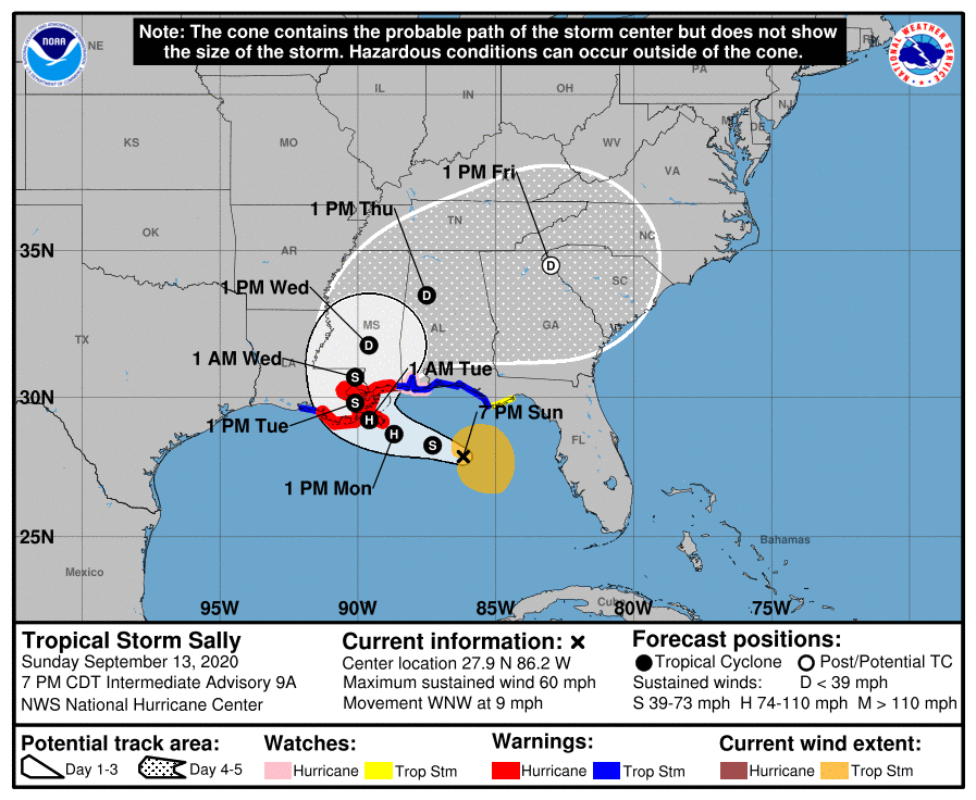
Tropical Storm Sally will be lumbering onshore along the Louisiana, Mississippi, Alabama, and Florida Gulf Coasts sometime Tuesday, dumping a ton of rain on that area in the process. It’ll be a slow-mover, and some extreme rainfall totals (upwards of 15-20″) are in the forecast for that neck of the woods.
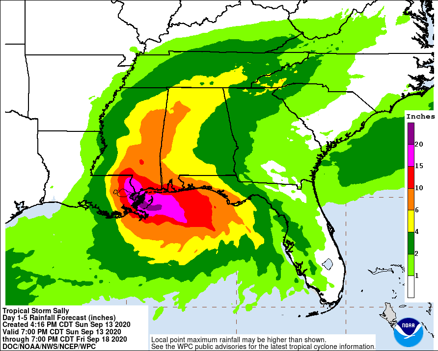
On the current NHC track, the heaviest rain heads up Alabama and Mississippi on Wednesday into Thursday as Sally is picked up by a frontal system and deflected northeast. Guidance has not yet totally settled down on where Sally ultimately ends up, but all indications are that the heaviest rain will stay to our northwest. We’ll want to monitor for any changes to the forecast which could potentially tick our rain totals up a bit, but for now, expect Sally to remain just a peripheral part of our forecast.
Below-normal temperatures to continue
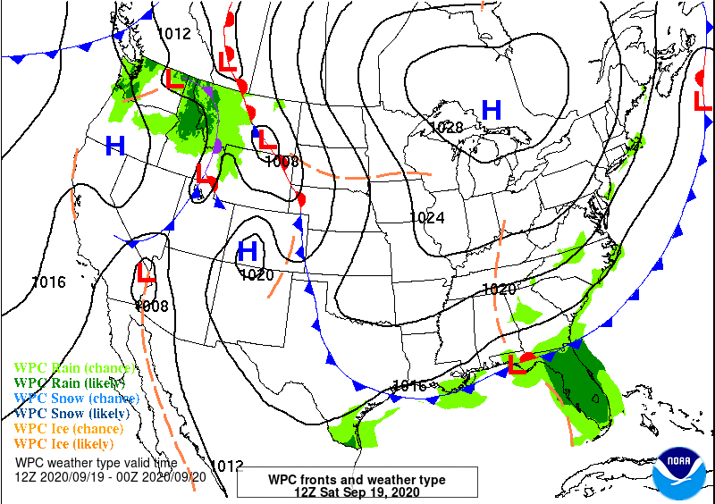
Once the aforementioned front gets through late Friday/early Saturday, high pressure will begin to build back in from the northwest. This will usher in another round of cooler air, and keep high temperatures capped in the low 80s (and perhaps upper 70s). We’ll want to watch for a few residual showers Saturday before a drier Sunday lies ahead.
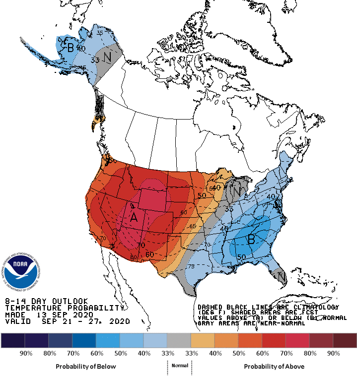
It looks like this cooler-than-normal air will have some staying power, too. The Climate Prediction Center’s outlook ending September 27 continues to keep good probabilities of below-normal temperatures well into the second half of the month. (Unfortunately, this comes to us at the expense of continued drier and hot conditions out west, where a historically terrible fire season rages seemingly unabated.)
Coastal flooding to be an issue in the evenings this week
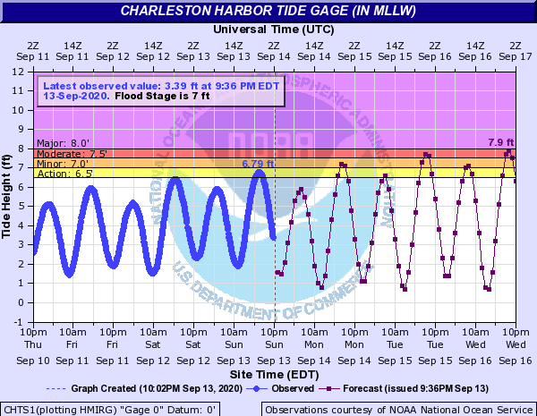
Onshore winds and the upcoming new moon will combine to produce coastal flooding with the evening high tides this week. These tides could produce fairly widespread coastal flooding as we get into mid-week, with an early call of 7.9′ possible Wednesday evening. Keep an ear out for Coastal Flood Advisories as road closures appear increasingly likely as the week wears on.
Historically, fall is a time where we see a lot of coastal flooding events. This is partially due to the seasonal uptick in tropical cyclone activity around this time of year, but also can be traced back to the increased frequency of setups much like we are going to see this week: high pressure wedging down the Appalachians, turning winds northeasterly to easterly, helping water to build up beyond astronomical levels. (And yes, rising sea levels linked to climate change are also a factor in the overall number of coastal flood events.) The National Weather Service in Charleston recently revamped their coastal flood database, which does a wonderful job laying out the frequency of coastal flood events since 1953. If you’re interested in this stuff, I highly recommend taking a look.
Follow my Charleston Weather updates on Mastodon, Bluesky, Instagram, Facebook, or directly in a feed reader. Do you like what you see here? Please consider supporting my independent, hype-averse weather journalism and become a supporter on Patreon for a broader look at all things #chswx!