Weird Saturday, but sunny Sunday
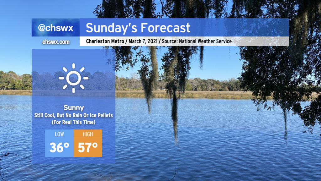
It was a weird Saturday. (More on that in a minute.) Fortunately, Sunday will restore order to the forecast as clouds dissipate overnight in response to high pressure building back into the area. Despite full, unencumbered sunshine, we’ll stay quite chilly tomorrow, with the high of 57° coming in well under the normal of 68° for this point in March. Frost and even a light freeze will be possible overnight Sunday into Monday, too, so be ready to protect plants and pets.
But yes, no surprise rain or ice pellets. For real this time. And thankfully (for our psyches, anyway), we look predominantly dry well into next week and perhaps beyond.
This morning’s rain and ice pellets
It was weird enough that it rained measurably this morning. A few sprinkles weren’t totally in doubt as upper-level energy swung through the area, but there was just enough lift to squeeze out some measurable rainfall despite a fairly dry atmosphere, especially below 4,000 feet.
Rain it did, though, and so that part of the otherwise dry forecast busted. Then it got weird:
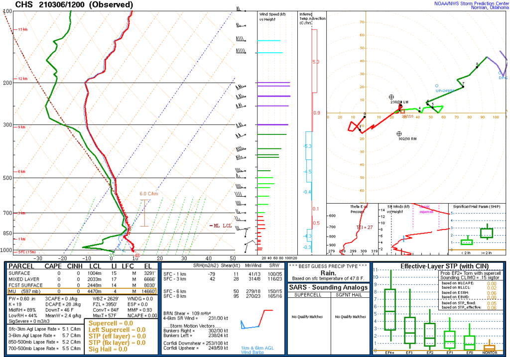
…sleet? That’s so March. Ice pellets, though, fell across many parts of the Lowcountry, from the Summerville/Knightsville area into West Ashley. If you get a look at the data points in the sounding above, one notices the freezing level (FZL) around 3,950′. That’s fairly low, for sure. Where that was low, the wet bulb zero altitude — the point at which a saturated parcel of air would reach freezing — was 2,629′.
Looking back at the sounding, we trace the red (temperature) and green (dewpoint) lines up the skew-T chart to see them start very spread out toward the surface, indicating the aforementioned dry air. But as you go beyond 4,500 feet or so, the temperature and dewpoint lines get much closer together, indicating the cloud and precipitation layer.
So what happened? Precipitation emanating from the cloud layer above 4,500 feet in the form of snowflakes were falling into the drier and warmer air and evaporating. The act of evaporation cooled the surrounding air, and the air thus moistened and approached its wet-bulb temperature. As noted above, the wet-bulb zero height was well below the freezing level by a good 1400 feet. This “wet-bulbing” gave frozen precipitation a little more time as frozen precipitation before entering the rather warm layer at the surface (temperatures were at or above the mid-40s throughout the event). The lower the freezing level, the better the chance that at least a little frozen precipitation could survive to the ground…and so it did.
Here’s what the National Weather Service had to say about it:
When sleet isn’t sleet
The mind-blowing-but-makes-sense-when-you-think-about-it part, though, was that this wasn’t actually sleet. NWS explains:
The key to precipitation becoming sleet is that snowflakes fall through a shallow warm pocket aloft, melt some, and then re-freeze before reaching the surface.
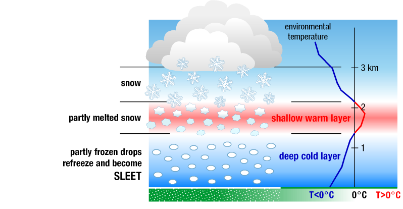
Source: National Severe Storms Laboratory
However, referring back to our sounding above, it’s clear that the air aloft does not warm and then refreeze below 4,000 feet — it’s above freezing from then on. It’s just that the snowflakes falling into the dry layer were able to keep some frozen properties longer thanks to evaporative cooling around it, allowing it to reach the surface as a mix of rain and ice pellets.
The atmosphere’s weird, man, but that’s why we weather nerds are drawn to it, after all.
South Carolina Severe Weather and Flood Safety Week begins Sunday
It’s hard to believe after today’s wackiness, but severe weather season is right around the corner. Here in the Lowcountry, the peak of the spring severe weather season generally runs from mid-March through May. As such, the National Weather Service in conjunction with the South Carolina Emergency Management Division are co-sponsoring South Carolina Severe Weather and Flood Safety Week starting on Sunday, with a new topic each day. I’ll be carrying severe weather safety information on the @chswx social channels, and don’t forget to follow @SCEMD and @NWSCharlestonSC as well for lots of really good information on how to stay safe in severe weather.
Statewide tornado drill Wednesday morning
Of note: The annual statewide tornado drill will occur Wednesday at 9AM. The National Weather Service will issue a test tornado warning with the TOR code. This will, in turn, trigger NOAA Weather Radios to sound their alarm tone indicating a warning. (This will not trigger Wireless Emergency Alerts or most other systems.) Use this time to practice your tornado safety plan at your home or business. (Be sure to take COVID precautions if practicing tornado safety outside of your bubble.)
I hope you’ll follow along and find the information valuable!
Follow my Charleston Weather updates on Mastodon, Bluesky, Instagram, Facebook, or directly in a feed reader. Do you like what you see here? Please consider supporting my independent, hype-averse weather journalism and become a supporter on Patreon for a broader look at all things #chswx!