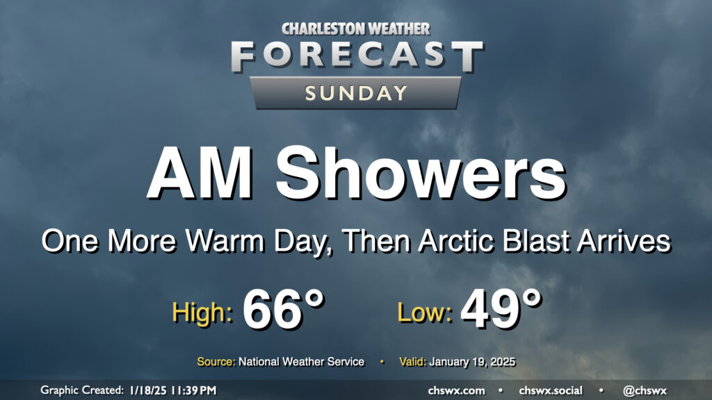
Showers will be ending by early Sunday afternoon as a cold front sweeps through the area later in the day, the forerunner to a much colder Arctic airmass that will arrive overnight Sunday into Monday, setting up a period of impactful winter weather starting Tuesday afternoon.
Temperatures on Sunday will be as warm as they will be for the forecastable future, with highs peaking in the mid-60s early in the afternoon after a start near 50° before falling off post-frontal passage later in the afternoon. We’ll get some peeks of sun as we head through the afternoon and early evening before sunset as much cooler and drier air filters into the area behind the front.
We remain on track to have a relatively quiet but cold day of weather on Monday before winter weather in the form of freezing rain and snow starts to affect the area beginning Tuesday afternoon through Wednesday. I’ll have a more in-depth look at this with Sunday evening’s post as we start to get more of the high-resolution data in, but long story short, we’re quite possibly going to see the most impactful winter weather in the area since 2018 this week. Stay tuned!
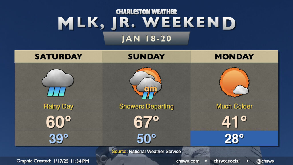
We have a rainy day on tap for Saturday as a complex storm system sweeps across the eastern half of the country. We’ll start the day in the upper 30s to around 40°, but warm to around 60° in the afternoon as warm, humid air moves in ahead of the storm system’s cold front. We’ll stay in the rain for a fair bit of the day after daybreak, though there will be breaks at times as well.
Showers depart early in the day on Sunday, which will be the warmest day in the forecastable future as highs top out in the mid-60s ahead of the cold front. Said front should swing through by evening, and we’ll start to see a sharp change in the airmass after that as Arctic air spills into the region from the northwest. Lows on Martin Luther King, Jr. Day bottom out in the upper 20s, heading to only the low 40s despite plenty of sunshine.
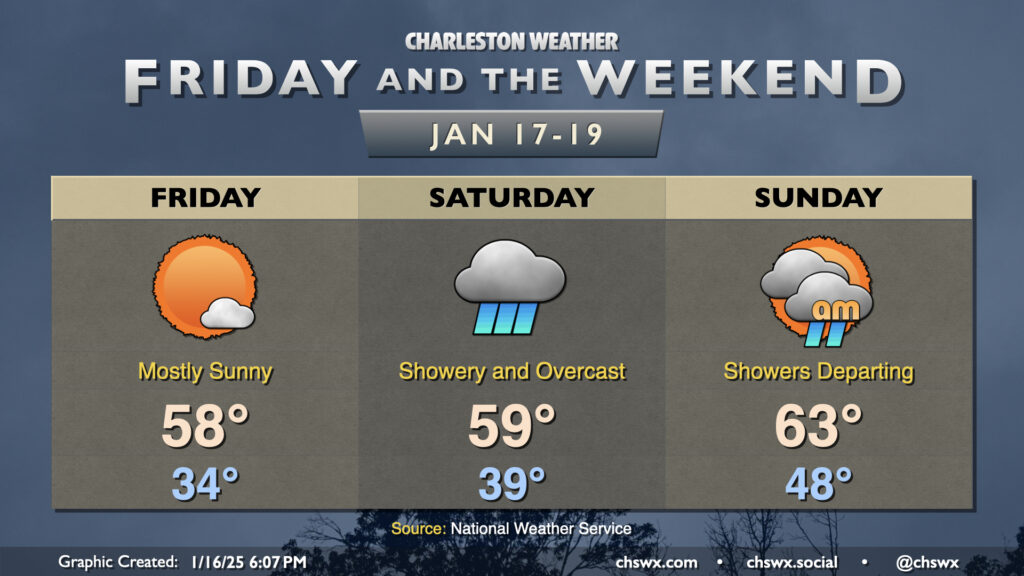
Friday will offer one more quiet day before an extended unsettled period kicks in starting this weekend, culminating in possible winter weather for the middle of next week.
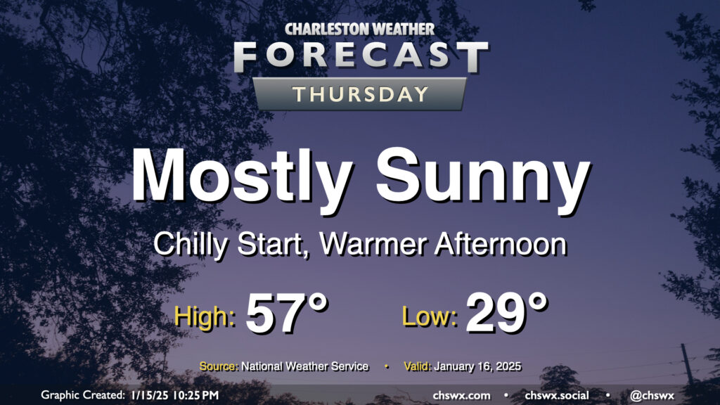
We start Thursday in the upper 20s to low 30s across the metro, but temperatures will ultimately end up a few degrees warmer than Wednesday under mostly sunny skies. This will be the second to last day of generally quiet weather before an unsettled period begins this weekend and lasts into next week, which will turn very cold and perhaps somewhat interesting winter weather-wise, too.
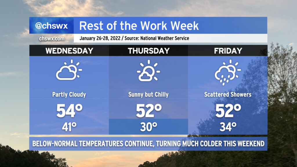
There’s not much to write home about weather-wise for the rest of the work week as generally quiet conditions continue through Friday before turning more unsettled over the weekend.
We start Wednesday right around freezing as a dry front comes through, which will help hold highs down to the low 50s in the afternoon despite plenty of sunshine. Winds turn a little more westerly on Thursday, and after a subfreezing start, we’ll warm to the mid-to-upper 50s in the afternoon under plenty of sunshine. We’ll keep this going for one more day on Friday, with lows right around the freezing mark and highs in the mid-50s with plenty of sun.
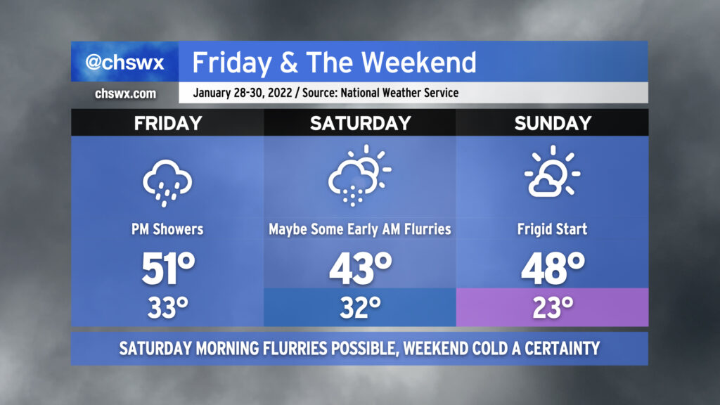
Well, here we are getting into the weekend with another storm system primed to affect the area. Overcast skies will be the rule for much of Friday as showers develop in the afternoon on the periphery of offshore low pressure. Temperatures will only top out around 50-51° given the lack of sunshine and northerly component to the wind.
As we get into the overnight hours Friday into Saturday morning, showers could give way to some snow flurries as colder air punches into the area. I always urge caution with cold-chasing-moisture scenarios like the one we will find ourselves in, but as an upper low traverses the area on the heels of the surface low pressure system moving northeast, it’s certainly conceivable that parts of the Tri-County, especially along and north of a Summerville-Moncks Corner-Jamestown line, could see a period of snow. Flurries will be possible all the way to the coast and perhaps as far south as Edisto as we get toward daybreak Saturday. Accumulations, if any, will be quite light and confined to grassy surfaces, and travel disruptions are not expected. And yes, folks — there will be no ice.
While the risk for snow is still quite conditional (and, to be fair, may not fully pan out), the certainty in the forecast is another shot of Arctic air that will turn this weekend frigid. Temperatures will struggle into the low 40s on Saturday afternoon despite cloud cover scouring out, producing clear skies by the afternoon. Sunday morning is setting up to rival the coldest of the season with lows in the low 20s expected in the Charleston metro area. This is potentially pipe-busting cold, and you’ll need to make sure that pets, plants, pipes, and people are safe and sound Saturday night into Sunday morning. Any bit of light wind could bring the wind chill factor into the upper teens on Sunday morning, too. We’ll keep plenty of sun in the forecast for Sunday, but even then, highs will likely not crack 50°.
The good news is that we begin a sharp warming trend on Monday. As we get into later in the new work week, we may even flirt with 70° for a time. With that in mind, though, the large scale pattern continues to favor generally cooler-than-normal conditions in the eastern half of the US, so don’t change out the wardrobe at the first sign of upper 60s just yet.
We remain chilly for the rest of the week with below-normal temperatures persisting, but this will feel warm compared to what we’ve got coming for the weekend.
First, though, we’ve got to get through the work week. A cold front comes through early tomorrow, helping to clear out the cloud cover and sprinkles we saw today. Cold air moving in behind said front will keep high temperatures suppressed into the mid-50s despite the increasing sunshine.
Cold air will continue to blow into the area on Thursday, allowing air temperatures to drop below freezing and morning wind chills to bottom out near 20°. It’ll be a good day to layer up; 52° isn’t terribly warm still, but it will certainly feel better than a feels-like temperature of 21° in the morning.
High pressure will then begin to give way to low pressure developing somewhere off the Southeast coast on Friday. This will help generate some scattered showers throughout the day into early Saturday before the low pressure system moves away from the area, potentially bringing quite a snowstorm to the Northeast before it’s all said and done. Said low pressure will drive a sharp cold front through, and lead to weekend highs in the 40s and a very chilly Sunday morning of low 20s.
Here’s a little weather whiplash for you: We got to 73° today at the airport. Tomorrow, we won’t even reach 40°.
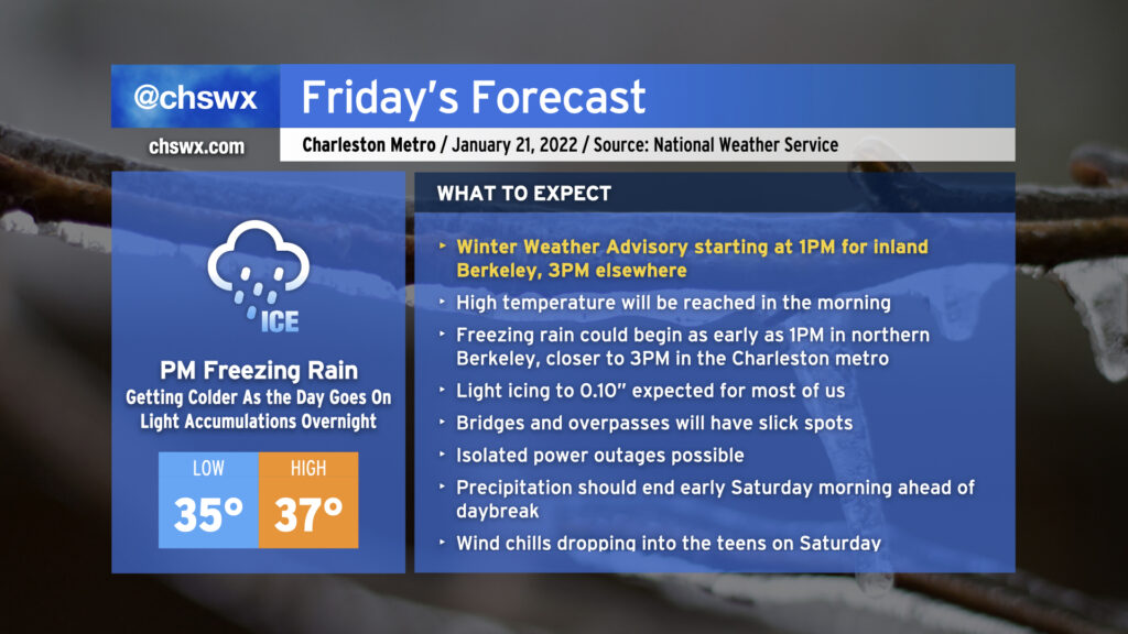
A cold front is sinking steadily southward in our direction this evening, which will allow a wedge of Arctic high pressure to steadily build in from the north as we get into Friday. We’ll start the day in the mid-30s, warm up to the upper 30s, and then temperatures fall below freezing in the afternoon, all while light rain blankets the area. As the freezing line moves southward, so will the changeover to freezing rain, generally on elevated surfaces (including bridges and overpasses.) This freezing rain threat will arrive by Friday evening and stick around through early Saturday before low pressure departs and brings the stalled front with it.
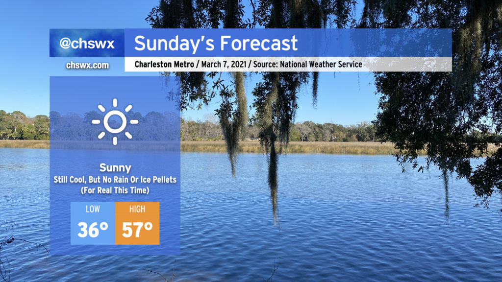
It was a weird Saturday. (More on that in a minute.) Fortunately, Sunday will restore order to the forecast as clouds dissipate overnight in response to high pressure building back into the area. Despite full, unencumbered sunshine, we’ll stay quite chilly tomorrow, with the high of 57° coming in well under the normal of 68° for this point in March. Frost and even a light freeze will be possible overnight Sunday into Monday, too, so be ready to protect plants and pets.
But yes, no surprise rain or ice pellets. For real this time. And thankfully (for our psyches, anyway), we look predominantly dry well into next week and perhaps beyond.
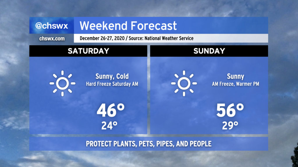
Get ready for a hard freeze tonight as temperatures plummet into the low-to-mid-20s pretty much everywhere inland of the immediate coast, where temperatures will still likely reach freezing. While winds will die down a little, there will still be enough to send wind chills into the upper teens for Saturday morning. Protect plants, pets, pipes, and people tonight.
Saturday will be another day where temperatures struggle into the mid-40s despite full sunshine. After another freeze Sunday morning, temperatures will begin to moderate, topping out in the mid-50s in the afternoon with plenty of sunshine to continue.