Rain returns for Tuesday
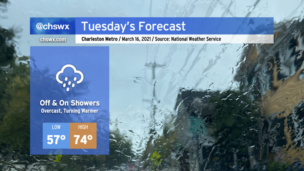
Well, it was nice while it lasted, but the rain is back overnight tonight into Tuesday as energy aloft as well as a surface low ripple along a stationary front to keep shower chances in the forecast, especially as we get into the evening hours. Expect the wedge front to retreat northward across the area during the day, with temperatures heading into the mid-70s in the afternoon in the metro area. 70s become a little less certain the further north and west you go; that will be governed strongly by just how far north the wedge front can retreat throughout the day. Models indicate a steep drop in temperatures across the front, potentially keeping areas near I-95 some 10-20° cooler than coastal areas.
A thunderstorm or two can’t be ruled out as we get into Tuesday afternoon and evening. A sampling of model soundings around the area suggest that a stronger storm or two may be in the cards, so we’ll want to keep an eye on this. However, no widespread severe weather is expected Tuesday.
A breezy day in the Lowcountry
As high pressure wedged into the area, we had quite a breezy day across the Lowcountry, with WeatherFlow stations recording gusts as high as 47 MPH at the Shutes Folly station in the harbor. Gusts were as high as 33 MPH at the airport earlier today, as well. We remain breezy near the coast this evening, with winds shifting to the southwest in the wake of a warm front tomorrow.
Severe weather threat for Thursday
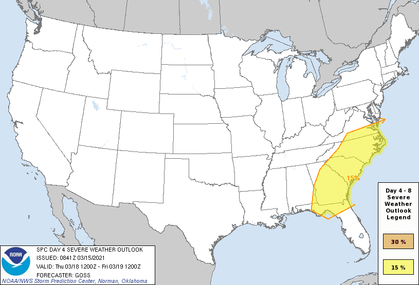
We will want to continue to keep an eye on Thursday’s forecast for the risk of a line of strong to severe storms ahead of a cold front in the afternoon and evening hours. There is still a fair bit of uncertainty with the exact details of the forecast this far out, but the Storm Prediction Center has enough confidence in the overall scenario to maintain a 15% (slight) risk area for severe storms across the Southeast coastal states, including the Carolinas. Timing of the line is going to be key, and this is still where there is some model disagreement. Keep an eye out for updates as forecasts are fine-tuned.
Regardless of what may or may not transpire Thursday, we are heading into the spring severe weather season in our neck of the woods. It’s a good time to review your severe weather safety plans and identify at least two reliable ways to receive weather warnings. There’s a lot of great information on how to do these things and more at the National Weather Service’s Spring Safety website.
Follow my Charleston Weather updates on Mastodon, Bluesky, Instagram, Facebook, or directly in a feed reader. Do you like what you see here? Please consider supporting my independent, hype-averse weather journalism and become a supporter on Patreon for a broader look at all things #chswx!