Wednesday: Some calm before Thursday’s storms
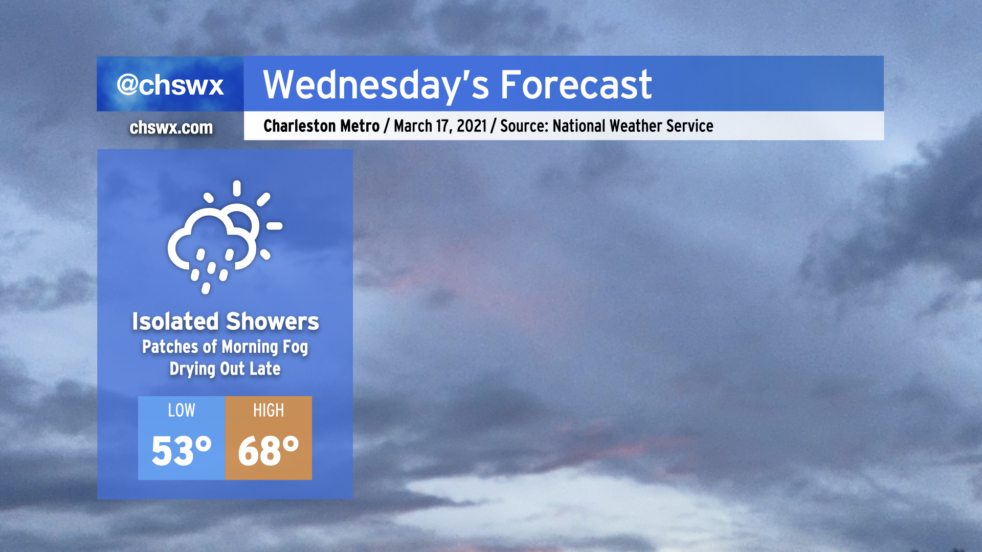
Another round of rain is expected overnight tonight as an upper-level disturbance moves through, with isolated showers possible during the day Wednesday.
The high pressure wedge won the day today, keeping temperatures well below forecasted levels in the low to mid-60s in the Charleston metro, while Moncks Corner struggled to 50°. It appears that the wedge will once again put a dent in temperatures tomorrow, with highs in the upper 60s in the Charleston metro perhaps being a bit generous if this afternoon’s high-resolution model runs have anything to say about it. Bottom line: Don’t misplace the light jacket tomorrow, preferably the green one given St. Patrick’s Day.
While we’ll be relatively calm tomorrow, a severe weather outbreak is expected from western Tennessee to Alabama as a strong storm system moves across the Mid-South. This storm system will head eastward and play a potentially major part in our weather on Thursday.
Severe weather threat for Thursday
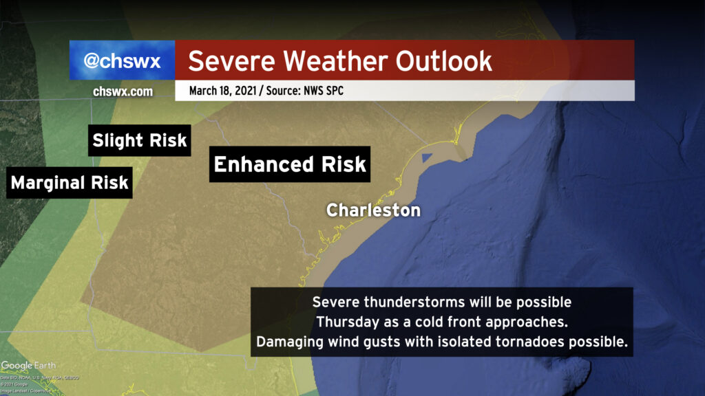
The first spring severe weather threat of 2021 looks to arrive in the Lowcountry on Thursday as the aforementioned storm system rumbles eastward, dragging a cold front into the Southeast. It’s expected that along and ahead of this front, showers and thunderstorms will be ongoing, and the environment will be capable of sustaining severe thunderstorms. Wind shear is not an issue, but guidance is still unclear on how much instability will develop, particularly as the line gets closer to the coast where marine influences should stabilize the atmosphere a bit and tamp down (but not eliminate) the risk for significant severe weather.
Still, damaging wind gusts and perhaps a tornado or two cannot be ruled out as the line marches eastward. If individual, discrete cells can form in the environment ahead of the front, those would carry a greater tornado risk.
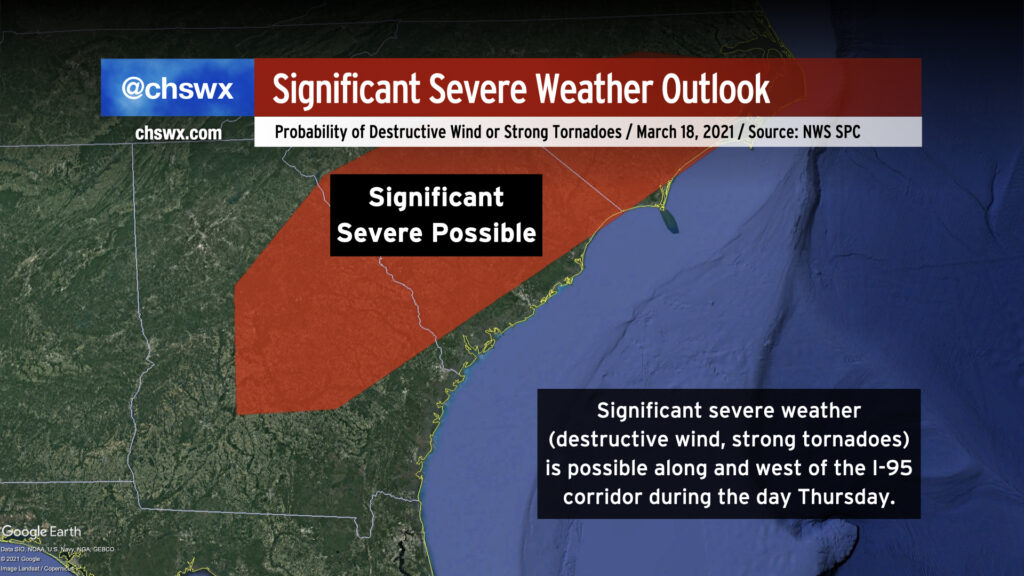
The Storm Prediction Center’s outlook indicates a risk for significant severe weather generally along and west of I-95 on Thursday. It is here — think the CSRA to the Midlands into the Pee Dee — where there appears to be the greatest risk for a couple strong tornadoes and possibly destructive straight-line wind gusts. Today’s guidance continues to lend credence to this forecast idea, so those of you near I-95 in the northwestern portions of the Tri-County will especially want to keep an eye on the severe risk.
The event is beginning to come into range of some of the higher-resolution, convection-allowing models, so expect continued fine-tuning to the forecast during the day tomorrow. Check back for updates tomorrow morning and again in the evening. Additionally, tomorrow will be a good day to make sure you have reliable alerting sources — NOAA Weather Radio and smartphone apps such as any of the local news apps are a good place to start. Make sure your Wireless Emergency Alerts are turned on in case of a tornado warning on Thursday, and brush up on your severe weather action plan so you know where to go in case a warning is issued.
Administrative note: @chswx alerts are being updated
The @chswx infrastructure finished a transition to shiny new virtual machines over the weekend. (@chswx supporters got all the gory, geeky details earlier this week!) While the website is up and running, I am still working out some details with the automated weather alerts we’ve come to know and love through Twitter. In the interim, I have set up alerts from the Iowa Environmental Mesonet to alert on tornado, severe thunderstorm, and flash flood warnings automatically. They look like this (imagine @chswx branding on them):
The Iowa Mesonet alerts, while they may not read as cleanly, do offer a polygon graphic to outline exactly where the warned area is. The old bot just wasn’t built to decode the polygon coordinates in each warning, leading it to send generic messages for warnings for whole counties. In reality, they haven’t been this way since storm-based warnings were introduced in 2007, so hopefully you will find the new alerts actionable. The Iowa Mesonet bots are based on technology built for the National Weather Service and use the same real-time weather data feeds that the @chswx bot does, so they are good and reliable for the short term. (But never fear, my custom alerts are coming back!)
With that in mind, though, I do reiterate the importance of having redundant and reliable warning methods. Social media is another way to maintain situational awareness, but providers can be fickle about showing you the information in a timely manner (looking at you, Facebook and Instagram) and aren’t subject to the same rigorous reliability checks that, say, NOAA Weather Radio or Wireless Emergency Alerts are. When it comes to matters of protecting life and property, it’s important to have those reliable warning methods so that you’re not caught off guard.
Follow my Charleston Weather updates on Mastodon, Bluesky, Instagram, Facebook, or directly in a feed reader. Do you like what you see here? Please consider supporting my independent, hype-averse weather journalism and become a supporter on Patreon for a broader look at all things #chswx!