The week ahead: Getting warmer, with scattered storms mixing in

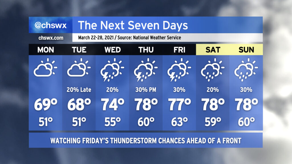
We’ll be warming up as the week goes on — the last full week of March, already! — with isolated to scattered showers and storms possible beginning Tuesday night. The next significant storm system on the docket is expected to arrive sometime Thursday or Friday, but persistent low pressure keeps rain chances in the picture well before that.
Gusty winds will continue overnight into Monday, with 30-40 MPH gusts possible near the coast and on bridges. This is due to a tight pressure gradient between a wedge of high pressure inland and a surface low migrating northeastward off the coast. Northeast winds look to relax a little on Tuesday, but could still be gusty at times near the coast. A High Surf Advisory and a High Risk of Rip Currents is in effect for Monday — not a great beach day, for sure.
Staying unsettled into the weekend
High temperatures should rise into the 70s starting Wednesday (wedge willing) and look to stay there for the rest of the week, despite occasional showers and storms. Troughiness near the coast should begin to lift northward on Wednesday as the wedge erodes. This combined with some upper-level energy rippling through could kick off some showers and maybe a thunderstorm. No severe weather is expected.
We look to catch a break in the rain Wednesday night into Thursday before the next storm system begins to approach the area. We could begin to see a recurrence of scattered storms on Thursday, with slightly better rain and thunder chances as we get into Friday.
A sampling of modeled sounding data valid Friday afternoon from the main global models suggests that there could be at least a marginal severe weather risk with ample shear and available instability ahead of the front. Exact details are near impossible to nail down this far out, so we’ll just keep an eye on this for now and see how it evolves as the week progresses.
Follow my Charleston Weather updates on Mastodon, Bluesky, Instagram, Facebook, or directly in a feed reader. Do you like what you see here? Please consider supporting my independent, hype-averse weather journalism and become a supporter on Patreon for a broader look at all things #chswx!