Rest of tonight: Off and on rain to continue, severe weather threat has diminished
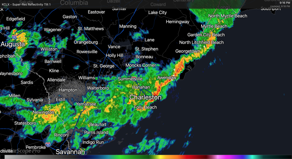
As of about 9PM, Claudette’s center was moving eastward across northern parts of South Carolina. The exact center fix is a little murky, but radar suggests that as of this writing it is roughly riding the SC/NC border around Chesterfield County, SC. The leading edge of Claudette’s primary rain band has cleared downtown Charleston and is headed offshore, with light to moderate rain behind it. This rain band appears to have cleared downtown with relatively little fanfare, but winds have been gusting quite a bit, with a recent gust to 62 MPH recorded at the Isle of Palms WeatherFlow station.
Light to moderate rains look to continue for the next few hours as the primary rain band swings through the area. It appears that there could be additional showers and thunderstorms behind it; these are moving southeastward out of Augusta and could swing around into the Tri-County before it’s all said and done. A Flash Flood Watch continues across the Charleston Metro Area effective until 8am Monday, though this may yet be canceled early once this band lifts out.
The risk for severe weather (particularly the tornado threat) has ended across our area at this point. With the center directly to the north, surface winds coming out of the west lowering shear, and instability having been sapped by the rain band, the environment is not really conducive to tornado formation anymore. We caught a break with this today, especially considering the ample sunshine we saw for a good bit of the day to aid destabilization. Still, straight-line gusts of 40-50 MPH across saturated grounds could still be sufficient for downed trees and power lines, so keep flashlights nearby in case of power outages.
An unsettled week lies ahead
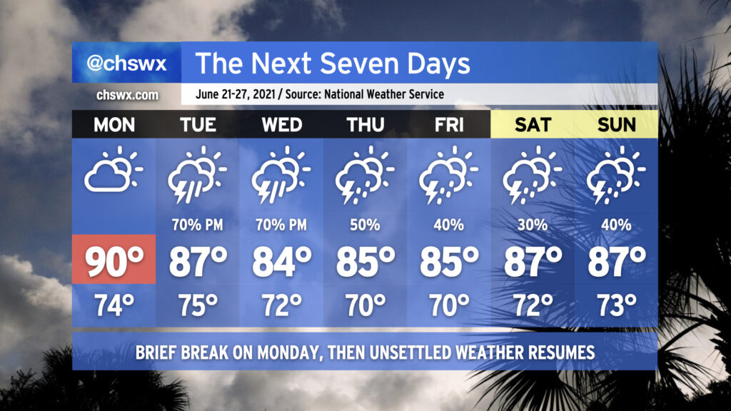
As we get into next week, we will have a brief break from the rain on Monday before jumping back into unsettled weather, particularly for mid-week. By Tuesday, a front will approach the area and stall out, keeping thunderstorm chances elevated through Wednesday. Heavy rainfall will again be possible as precipitable water values approach or exceed 2″. This could portend additional flooding problems depending on when and where heavy rain sets up, so we’ll need to watch trends carefully.
Deep moisture will stay in place as we close out the week into the weekend, keeping shower and thunderstorm chances around each afternoon. On the bright side, highs will be tempered somewhat by the cloud cover and nearby thunderstorms, with the only 90° day coming on Monday — fitting for the first full day of astronomical summer.
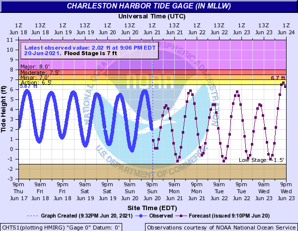
We’ll want to keep an eye on tides later this week as they may creep up toward 7′ in the harbor with a full moon approaching and onshore flow developing. Guidance is hinting that at least 7′ high tides become possible by Wednesday into Thursday. Right now, it’s just a trend to watch, but we’ll want to keep an eye on it nonetheless, especially given our recent heavy rain history and continued rain in the forecast.
Follow my Charleston Weather updates on Mastodon, Bluesky, Instagram, Facebook, or directly in a feed reader. Do you like what you see here? Please consider supporting my independent, hype-averse weather journalism and become a supporter on Patreon for a broader look at all things #chswx!