Scattered PM storms return Tuesday ahead of Elsa
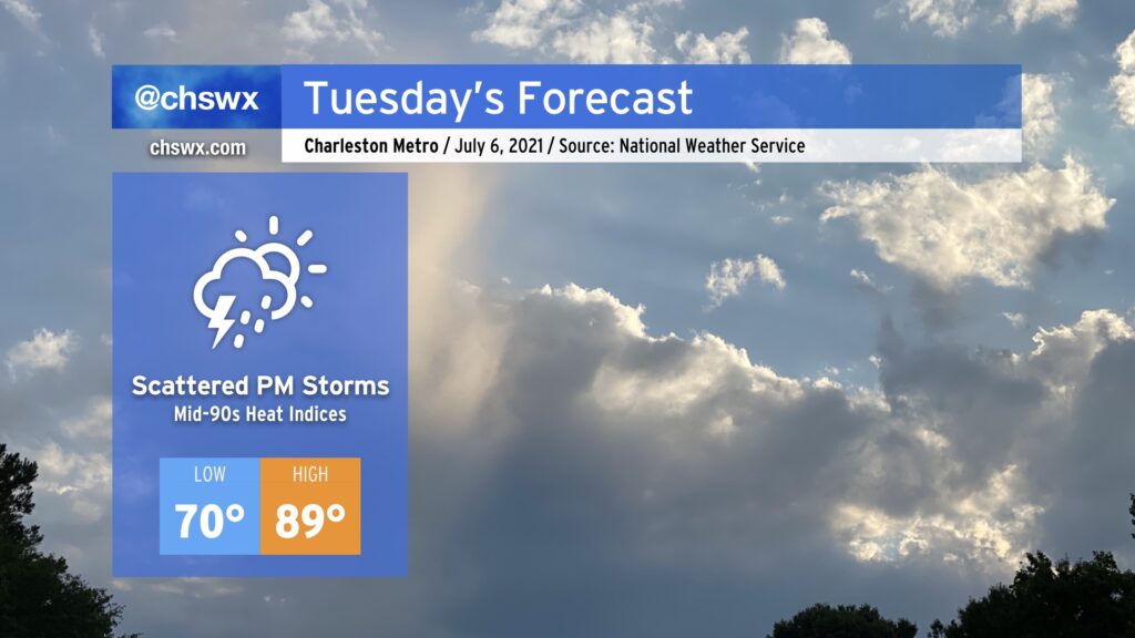
After a remarkably dry Independence Day weekend, we will get back to work and a somewhat more familiar July weather pattern on Tuesday as tropical moisture ahead of Elsa begins to spread northward into the area, enhancing shower and thunderstorm chances in the afternoon. Temperatures will top out in the upper 80s to near 90°, and humidity will push heat indices into the mid-90s. We in #chswx do not expect any direct impacts from Elsa on Tuesday, but it is possible that there will be at least a Tropical Storm Watch put in place by then, so don’t be shocked if one is issued.
Elsa makes landfall on Cuba, expected to emerge in the Florida Straits tonight
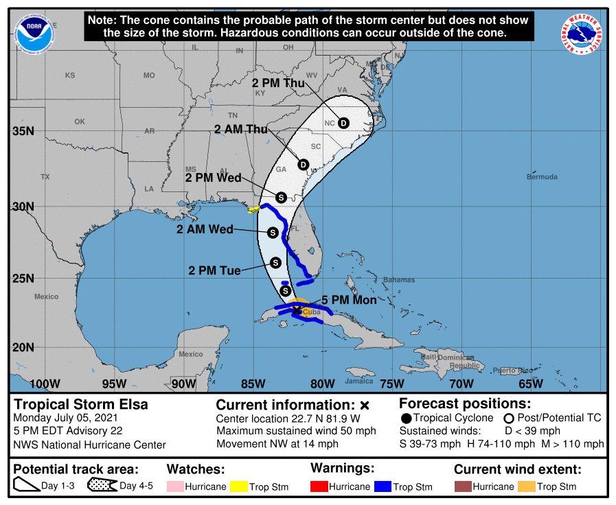
As of 5PM, Elsa was located over western Cuba, moving NW at 14 MPH. NHC estimates maximum sustained winds of 50 MPH, but mentions in their discussion that they will have a better idea when the Hurricane Hunters get back into the storm later this evening once it re-emerges over water.
Overall, we are starting to see the track models coalesce around a path that brings a weakened Elsa’s center roughly up I-95 through the Carolinas beginning Wednesday evening through Thursday afternoon. The NHC track for our neck of the woods has not changed much in the last 24 hours, and so it’s beginning to become a little clearer as to what’s what. Again, though, Elsa’s potential restrengthening in the Florida Straits and eastern Gulf remains a bit of a wildcard here at this point.
Based on the current NHC track, it appears the worst of the weather will arrive in our area beginning Wednesday afternoon as bands of rain move in from the south. Heavy rain will be the main concern, with gusty winds also posing an issue particularly at the coast. The Lowcountry will be in the right-front quadrant of Elsa as it advances northward, and as such, conditions may become favorable for a weak tornado or two particularly closer to the coast where instability may run a little higher. However, a major severe weather event is not expected at this time.
As mentioned in previous days, though, we need to get Elsa across Cuba and back into the Gulf to see what we are working with to begin to lock in some of the forecast details. We’ll be able to begin doing this tomorrow. In the meantime, it won’t hurt to make sure you have batteries in case of power outages Wednesday night/Thursday morning — something you probably should have anyway given our propensity for summer thunderstorms that can also produce power outages.
The next full track/intensity forecast is due from the National Hurricane Center at 11 PM, with an intermediate advisory updating position and strength at 8 PM. Stay tuned…
Follow my Charleston Weather updates on Mastodon, Bluesky, Instagram, Facebook, or directly in a feed reader. Do you like what you see here? Please consider supporting my independent, hype-averse weather journalism and become a supporter on Patreon for a broader look at all things #chswx!