The week ahead: Turning unsettled with a chance of Elsa
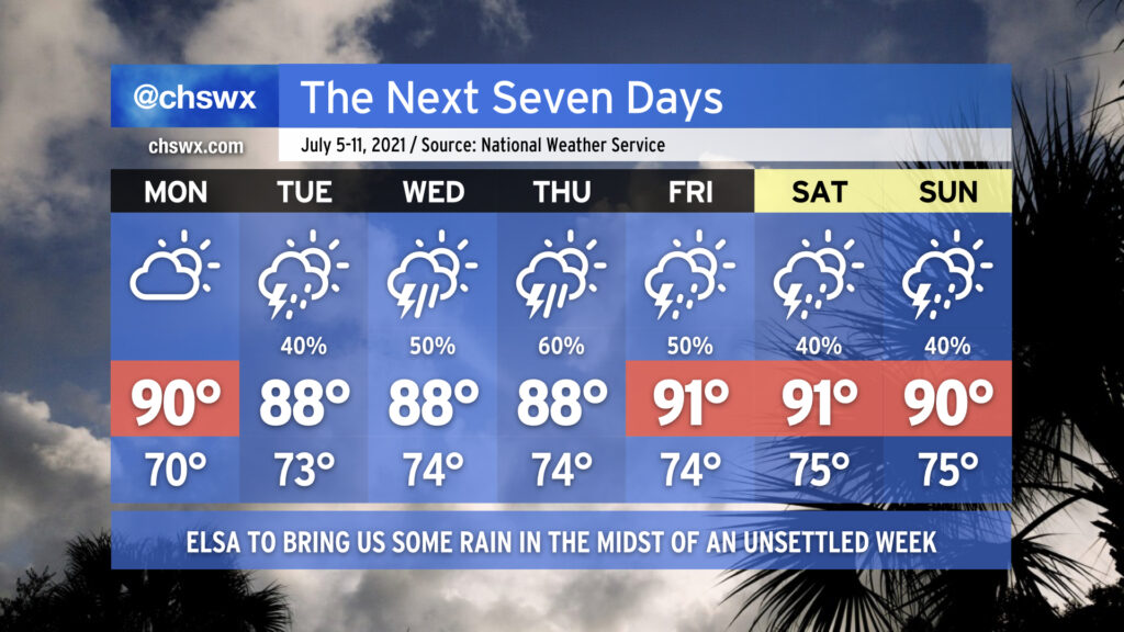
We get one more rain-free day on Monday to close out the observance of Independence Day before moisture and unsettled weather return to the picture. Much of this will be influenced by the eventual track and strength of Elsa, which as of the 5PM advisory, is currently forecast to be a depression as it traverses the area sometime Wednesday into Thursday (more on that in a sec). Overall, get ready for periods of showers and thunderstorms with heavy rain and temperatures right at or a little below normal each afternoon, particularly in the middle of the week as Elsa gets involved with the forecast.
Elsa at 5PM: A disorganized tropical storm preparing to cross Cuba
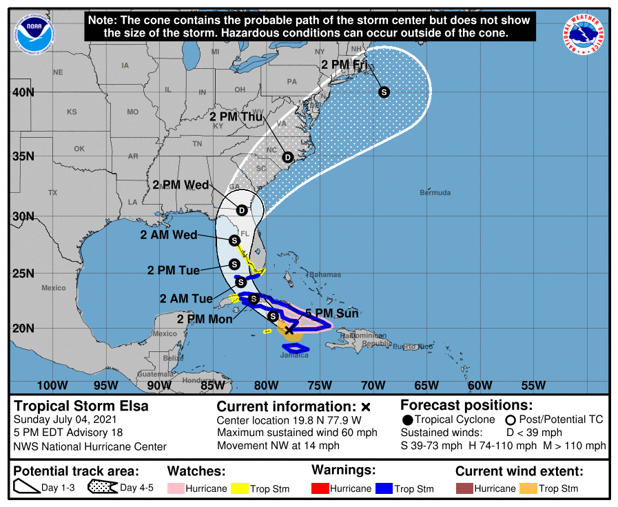
As of the 5PM advisory, Tropical Storm Elsa — a mid-range tropical storm suffering from disorganization due to wind shear — is headed NW at 14 MPH toward Cuba, where Tropical Storm Warnings cover basically the entire island at this point. Elsa will eventually cross Cuba and then head into the Florida Keys as a tropical storm late Monday/early Tuesday. It’ll have about a day in the Gulf, where it could pick up a little steam, before making landfall somewhere near Tampa overnight Tuesday/early Wednesday morning. From there, it is expected to accelerate up the East Coast, spreading tropical moisture northward into the Carolinas while weakening into a depression. It is forecast to regain tropical storm strength as it accelerates northeastward away from here sometime Friday.
As noted above, the current forecast brings this storm into the area as a depression, which would certainly be helpful as far as keeping wind impacts to a minimum. On this track, heavy rain is certainly the main concern, particularly near the coast, with periods of heavy rain possible as soon as Tuesday as Elsa’s moisture begins to stream northward well ahead of the center. A more inland track brings the risk for heavy rain a little further into the rest of the Tri-County, while a track taking the storm offshore may blunt the inland impacts.
The bottom line is that we aren’t really going to be sure what’s what until this storm crosses Cuba and maybe not until it makes landfall in Florida. Fluxes in intensity, the storm track, and storm timing could still make quite a bit of difference as far as what we experience here, so it remains relatively difficult to pin down exactly what influence Elsa will have beyond increasing rain chances for mid-week.
Over the next day or so, it probably isn’t a bad idea to double-check your storm supply kit (which is something to check on a fairly routine basis during hurricane season as a matter of course) and ensure you’ve got battery capacity for potentially some short-lived power outages as Elsa moves by later this week. Be sure to keep an eye on forecast updates over the next few days as the details will come into better focus as we kick off the rest of the week.
Follow my Charleston Weather updates on Mastodon, Bluesky, Instagram, Facebook, or directly in a feed reader. Do you like what you see here? Please consider supporting my independent, hype-averse weather journalism and become a supporter on Patreon for a broader look at all things #chswx!