Rest of the work week: Hot and mostly rain-free
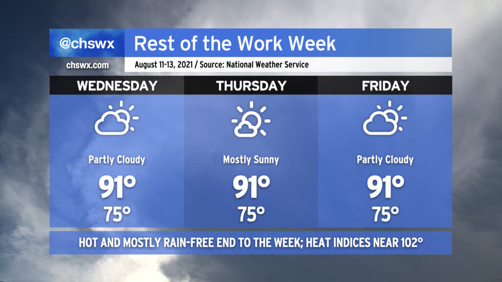
While we can never totally rule out a popup shower or storm in mid-August, high pressure both at the surface and aloft should put the kibosh on precipitation as we get over the hump and finish out the work week. The forecast is pretty standard each day — highs in the low 90s, lows in the mid-70s (running closer to 80° near the coast, including in Downtown Charleston).
We certainly can use the drying time; so far we’ve had 18.04″ of rain this summer, a surplus of just over 3″ (3.01″, to be exact). That’s good for 24th on record to this point. The summer of 1973 continues to reign supreme in the rainfall department, though, with 35.33″ recorded at the airport from June 1 to August 10. (It could always be worse.)
As we get closer to the weekend, we’ll see rain chances begin to head back up as deeper tropical moisture looks to work back into the area.
Potential Tropical Cyclone Six is still trying to organize
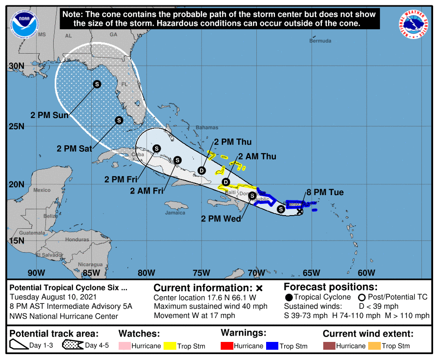
We continue to monitor Potential Tropical Cyclone Six as it passes just south of Puerto Rico this evening. It has 40 MPH maximum sustained winds and is moving west at 17 MPH as of the 8PM intermediate advisory from the National Hurricane Center. Recent satellite imagery and radar data continue to indicate that it is trying to close off a circulation, but is still somewhat disorganized. When the storm organizes a little more and develops a more coherent circulation, it will be classified as a tropical storm; the next name on the list is Fred.
PTC Six/future Fred will head west to west-northwest over the next few days, heading over the rough terrain of Hispaniola before emerging back into the Atlantic as a tropical depression. It is currently forecast to regain tropical storm strength and approach the Florida Keys by Saturday. The long-term outlook on Fred remains rather uncertain in ways that the standard cone graphic can’t properly capture. Tropical models do best when they have a center of circulation to initialize with, and they just haven’t had that yet. Once that gets established and this storm becomes Fred, we should begin to gain more confidence in the model data.
With that in mind, the pattern aloft does suggest that the basic track idea here is correct. The ridge of high pressure which is giving us this fairly dry week will also act to steer the storm westward toward the Gulf of Mexico over the next several days. So far, model agreement is unusually good in keeping that ridge strong enough to steer the storm into the Gulf, as reflected by the 4-5 day NHC forecast. We’ll see how this holds up, but it is a sensible solution provided the ridge remains as strong as modeled.
As always, things can change with these rather quickly, so it’s a great idea to check in on what this storm is doing occasionally. There’s nothing here remotely panic-worthy, though. We in #chswx will continue to keep an eye on it, and as things evolve, we’ll keep you posted!
Follow my Charleston Weather updates on Mastodon, Bluesky, Instagram, Facebook, or directly in a feed reader. Do you like what you see here? Please consider supporting my independent, hype-averse weather journalism and become a supporter on Patreon for a broader look at all things #chswx!