The week ahead: Enhanced tropical moisture around Fred keeps rain chances up
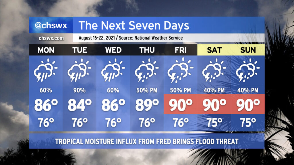
Our soggy summer rolls on with the return of widespread showers and thunderstorms for the first part of the week, particularly as Tropical Storm Fred makes landfall along the Florida Gulf Coast sometime tomorrow and moves northward through western GA into TN. While we won’t see direct impacts from Fred, we are certainly going to be within a plume of deep tropical moisture for the next several days, and this will lead to heavy downpours as a result. Models certainly suggest Tuesday as the wettest day as Fred lumbers up the AL/GA line. A few more inches of rain will certainly be possible, especially in isolated spots where the heaviest downpours occur. We’ll need to keep a close eye out for flooding issues, especially if heavy rain occurs near high tide downtown. The rainfall will keep temperatures in the mid-80s through Wednesday.
As we get into Thursday, Fred’s remnants will be out of the way and we look to begin to return to a somewhat more normal afternoon thunderstorm pattern heading into the weekend. Temperatures will respond by heading back to around 90° each afternoon before thunderstorms fire up.
Tropics remain busy, with a new depression possible soon near Bermuda
We’ve got three areas of interest in the Atlantic basin: Tropical Storm Fred, Tropical Depression Grace, and a wave that is likely to become a tropical depression as soon as tonight, according to NHC.
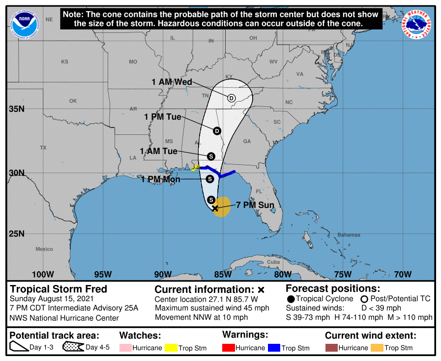
At 8PM ET, Fred had 45 MPH max sustained winds and was moving NNW at 10 MPH. It’s still on track for landfall sometime Monday afternoon or evening in the Florida panhandle, where Tropical Storm Warnings are out. From there, it will move inland through southeast Alabama into Georgia and eventually eastern Tennessee. This could spread some very heavy tropical rainfall up into the Upstate of SC and western North Carolina. By Wednesday, Fred should be post-tropical, accelerating northeast and out of our hair.
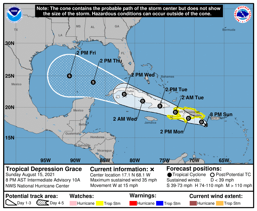
Tropical Depression Grace is currently fighting much of the same fight Fred did, experiencing land interaction and wind shear to keep it disorganized. NHC continues to show it as a depression heading over Hispaniola and Cuba before entering the Gulf of Mexico late this week. Disorganization can often lead to uncertainty, though, as Grace’s center remains ill-defined. I’d expect additional shifts in the track of this storm over time, but with high pressure holding firm to our north, it doesn’t appear to be a Carolinas concern (at least right now). Watching it.
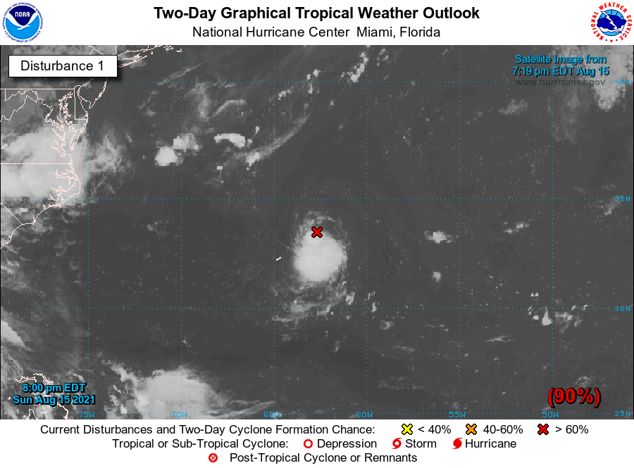
Finally, NHC has been watching an area of disturbed weather near Bermuda for tropical development. They give it a 90% chance of becoming the eighth depression of the season, and it could be classified as soon as tonight. Models keep this a thorn in Bermuda’s side for several days as it does a little whirl around the island before heading out to sea. If this storm is indeed classified and reaches tropical storm strength, its name would be Henri.
The good news: Despite how busy it is, we’ve got nothing scary out there, and I’ll happily take that in mid-August. We continue to barrel toward the peak of the hurricane season on September 10, and the expectation remains that we’ll be staying busy. Stay tuned…
Follow my Charleston Weather updates on Mastodon, Bluesky, Instagram, Facebook, or directly in a feed reader. Do you like what you see here? Please consider supporting my independent, hype-averse weather journalism and become a supporter on Patreon for a broader look at all things #chswx!