Rest of the work week: Turning much cooler and unsettled with a significant coastal flooding risk
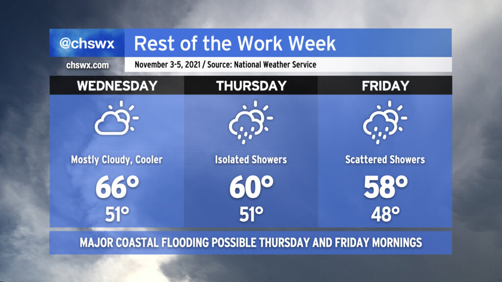
After a couple days of 70s and sunshine, cold air damming will begin to ooze into the area on Wednesday, kicking up cloud cover and keeping temperatures down into the mid-60s. It’s the first really good sweater weather day of the year, and the last fully rain-free day until Sunday. Thereafter, a storm system will affect our area from Thursday into the weekend. The wedge will remain intact through the rest of the work week, keeping gusty northeasterly winds — which could get as strong as gale force over the waters on Friday — in the area and cloud cover in place. Overrunning moisture will help contribute to a few showers on Thursday with more coverage Friday depending on where low pressure develops offshore. This, in turn, will help keep temperatures suppressed at or below 60° for Thursday and Friday. The last time we had a high below 60° was April 2nd, when the high topped out at a balmy 53°.
Major coastal flooding expected Thursday and Friday
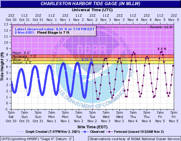
With high pressure wedging southward, northeasterly winds getting stronger, and astronomical influences from the new moon at perigee, expect salt water flooding at times of high tide beginning Wednesday morning. Minor to moderate flooding is expected with both high tides on Wednesday. Getting into Thursday, water levels head even higher. We are looking at some of the highest tides since Thanksgiving weekend of 2018 as we get into Thursday and Friday, with major flooding expected around commute time each morning and moderate flooding each evening. Water levels are forecast to approach 8.4′ on Thursday and 8.5′ on Friday. Guidance is advertising major flooding again Saturday morning, too. If this forecast holds, we’ll get at least one top-ten tide out of this. On top of this, showers are possible at times particularly Friday, which could make an already bad tidal situation even worse.
Eight-foot tides will close quite a few roads in downtown Charleston and cause flooding issues to develop on James Island and along Shem Creek in Mt. Pleasant. Be prepared for delays and the need to take alternate routes.
Expect flooding 2-3 hours around the times of high tide:
- Wednesday: 7:08am (7.3-7.5′), 7:22pm (7.3-7.5′)
- Thursday: 7:58am (8.3-8.5′), 8:12pm (7.6-7.8′)
- Friday: 8:48am (8.4-8.6′), 9:02pm (7.6-7.8′)
Stay tuned periodically for updates as this situation unfolds the rest of this week.
Follow my Charleston Weather updates on Mastodon, Bluesky, Instagram, Facebook, or directly in a feed reader. Do you like what you see here? Please consider supporting my independent, hype-averse weather journalism and become a supporter on Patreon for a broader look at all things #chswx!