The week ahead: A little more unsettled with fronts bringing shower chances
The week ahead features something we haven’t seen in a little while: legitimate rain chances across the metro area, thanks to a couple cold fronts poised to affect the area throughout the week.
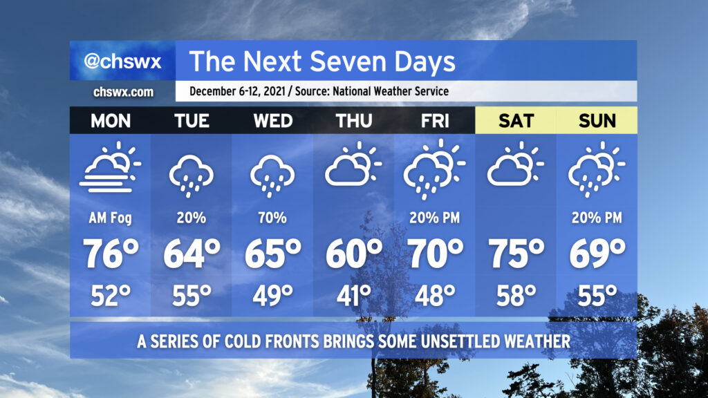
Monday begins with another foggy start, with the potential for dense fog certainly in play across much of the area to start the day. Be ready to slow down and use low beams during the morning commute. Temperatures will then rise into the mid-70s despite predominant cloud cover.
Temperatures take a tumble Tuesday as a cold front backdoors into the area, allowing high pressure to wedge down from the north. A few showers can’t be ruled out as southwest winds aloft overrun the wedge, causing lift, clouds, and some precipitation. The better shot of rain is on Wednesday as some upper-level help arrives to improve forcing for ascent and helps to shove another cold front offshore. Thursday looks to be the coolest day of the set as another high pressure wedge looks to take hold, keeping partly to mostly cloudy skies in place with temperatures struggling to reach 60°. We warm back into the 70s on Friday as we head into the weekend with slight shower chances at times.
We’ll also need to continue to monitor morning high tides for the first part of the week for minor tidal flooding thanks to the recent new moon at perigee. Right now, it looks like the 9:21am high tide on Monday could top out between 7.1-7.3′, which would produce some flooding near Gadsden Creek and perhaps even into the City Market. Tuesday and Wednesday mornings could also see minor flooding episodes. Keep an ear out for Coastal Flood Advisories from the National Weather Service.