The week ahead: Chilly, unsettled start gives way to a warm Christmas Day
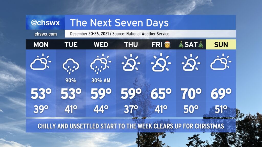
After a cold front came through and chilled us way out today, we will stay in this chilly pattern for a few more days ahead of a late-week warmup as high pressure wedges into the area. Monday looks to remain dry with peeks of sun amongst the clouds; chilly northeasterly winds will keep highs suppressed in the low 50s. Low 50s may be very optimistic for Tuesday’s highs given the potential for strengthening northeasterly winds and expected rainfall around a low pressure system throughout the day helping to reinforce the cool wedge.
Said storm system departs Wednesday, allowing us to dry out and warm up a little bit with highs near 60° in the afternoon. Even fewer clouds look to be an issue for Thursday as temperatures once again approach 60°.
By Friday, we will be heading into a warming trend that’ll put us in the upper 60s to low 70s for Christmas Day with continued sunny skies. Certainly no concerns for sleigh aviation overnight Friday into Christmas morning on Saturday, which is always welcome news.
Aside from the storm system on Tuesday, we’ll need to watch morning high tides this week for the potential for coastal flooding given the recent full moon and strong northeasterly winds. A major coastal flooding event is not expected, but minor salt water flooding could cause a few roads to take on water. We’ll especially need to watch Tuesday in case heavy rain coincides with high tide. Fortunately, as the pressure gradient near the coast relaxes, so will the coastal flooding threat.