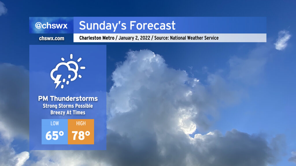
One more warm day Sunday before storms arrive in the afternoon
If you’ve not been a fan of this uncharacteristically warm weather that’s permeated the better part of the last week and a half around here, some good news: changes are coming in a hurry. However, that’s going to mean another round of storms with the potential for a couple of those to be on the strong side.
Before storms arrive, temperatures should once again rise into the upper 70s, challenging but likely not breaking the record of 81° set in 2017. We’ll start the day in the mid-60s, which if that temperature holds would come close to setting a record high minimum for January 2. It’ll be breezy, too, as winds increase from the southwest as a squall line approaches. Gusts 35-40 MPH certainly could be in the cards especially in elevated spaces.
Showers could begin as early as 10am, but the most likely time for precipitation to arrive is by mid-afternoon (think 2-3PM) as the main squall line gets into the area. Thunderstorms with sporadic damaging wind gusts look to be the main severe weather concern, but a tornado cannot be totally ruled out given favorable low-level shear (especially later in the evening as upper-level support improves). That being said, a widespread severe weather event is not expected.
Rainfall amounts should be relatively tame — generally a quarter to half-inch of rain for many of us — though a few spots could see over an inch of rain. The best risk for heavy rain looks situated in the I-95 corridor based on this evening’s high-resolution ensemble of models and will largely be determined by how strong the squall line is as it reaches the coast.
At some point in the afternoon, we should see a low pressure system develop along the front somewhere around the Georgia/Alabama line. As this low lifts north, a warm front will lift further to our north as well, keeping us in the warm sector through early Monday morning. It will be interesting to see what the daytime squall line ends up doing in response to this; some of the convection-allowing models don’t even bring it to the coast, favoring a situation where a second line of storms sets up directly ahead of the cold front and pushes through overnight. Something to watch, for sure, and we’ll just have to take it hour-by-hour as trends evolve tomorrow. Bottom line: Keep an eye to the sky, keep rain gear handy, and be ready to head in if you are outdoors and storms approach.
On Monday, around daybreak or a little after, though, expect the front to finally push through and a big cooldown in its wake. Temperatures are not going to follow a typical diurnal curve, and we should stay put within the 50s for much of the day as clouds scour out and cold air rushes in behind it. Winds look to stay elevated, too, with gusts to 40 MPH a real possibility. All in all, this frontal passage should put the kibosh on the extremely warm temperatures we’ve been seeing for at least the next week, keeping temperatures at or a little below normal through the first full work week of 2022.
Follow my Charleston Weather updates on Mastodon, Bluesky, Instagram, Facebook, or directly in a feed reader. Do you like what you see here? Please consider supporting my independent, hype-averse weather journalism and become a supporter on Patreon for a broader look at all things #chswx!