Tonight: Strong storms possible ahead of a potent cold front
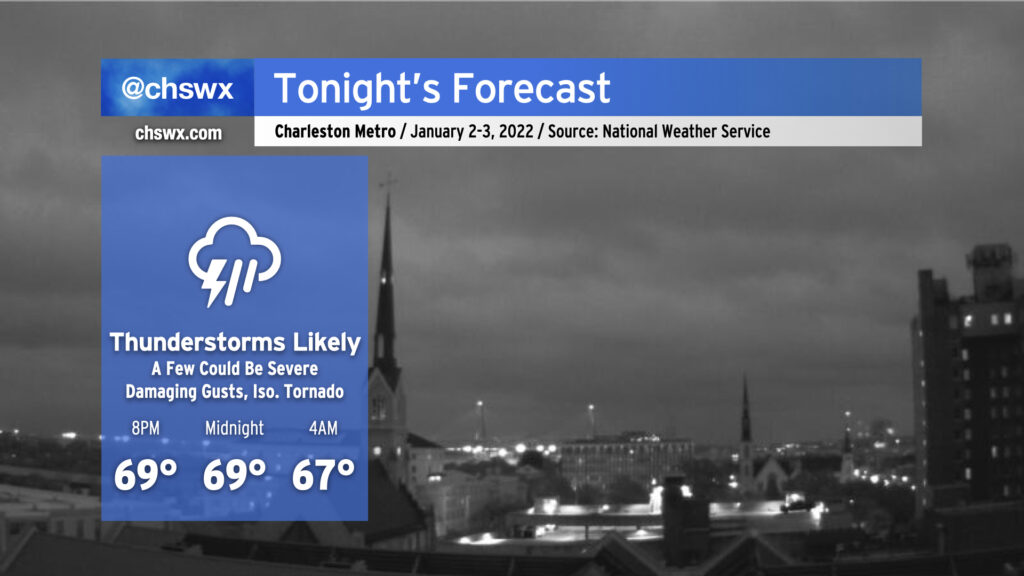
Tonight’s forecast is rather tricky. We’ve had a good bit of rain across much of the Tri-County today that has helped to knock temperatures back into the 60s in most spots, but it is still conceivable that a few severe thunderstorms may develop overnight.
Just to the south of Charleston lies what will become a warm front later tonight. Low pressure developing along the Georgia-Alabama border will move northeastward, dragging the warm front north of the area later this evening while a strong cold front drives in from the west, putting us solidly back in the warm sector in a moisture-rich environment. At the same time, the upper-level pattern will become more energetic, further strengthening the low. This will help kick winds up a little bit more at the surface while winds increase markedly aloft, helping to generate plenty of wind shear.
The question will be if there will be any instability for additional storms to fire and tap into this wind energy. If the airmass can recover and instability develops, there will be a risk for strong to severe thunderstorms overnight. Damaging wind gusts would be the primary concern, but there will be enough turning of winds with height such that tornadoes cannot be ruled out either. The best risk for severe storms in the Tri-County area will be roughly after midnight through 6am.
To be on the safe side, ensure phones are charged and can wake you in case a Tornado Warning is issued. It’s a good time to make sure your Weather Radio is ready to go, too. Local weather apps from all of the television stations will also alert you to any warnings that are issued. Make sure you know where to go if a warning is issued: an interior room on the lowest floor of a site-built structure is best. If you’re in a mobile home, make sure you know where the nearest community shelter is — you do not want to be in a mobile home if a tornado warning is issued for your area. With any luck, we won’t need any of this, but you’ll be happy you were ready in case the weather heads too far downhill.
The week ahead: Much more seasonable post-frontal passage
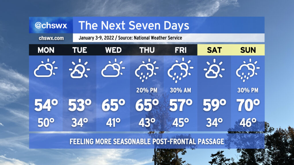
Once the cold front gets through Monday morning, the first full week of 2022 is going to feel much more like it should for this time of year. We’ll be getting the work week off to a very windy start with gusts to 40 MPH possible Monday morning as cold air rushes in. We won’t get out of the mid-50s in the afternoon despite gradually decreasing cloud cover. Tuesday will be particularly chilly with lows close to freezing in the metro (and likely touching freezing further inland) with highs topping out in the low 50s under mostly sunny skies. Then, temperatures begin to rebound a little bit for Wednesday and Thursday as high pressure slips offshore. The next rain chance will arrive Thursday afternoon into Friday morning as a front slides through the area. Friday afternoon and Saturday look good, if not a touch chilly, before another front approaches on Sunday.
Early-year coastal flooding issues to continue
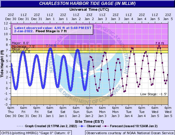
So far, we’re 2-for-2 for coastal flooding days in 2022. After a respite Monday, winds will turn more to the northeast beginning Tuesday, which will drive water levels back to minor flood stage in the morning. A more significant coastal flooding concern may arise on Wednesday, with water levels topping out solidly in moderate flood stage. These water levels would be high enough to cause some significant road closures in downtown Charleston, so we’ll be keeping a close eye on that throughout the week.
Follow my Charleston Weather updates on Mastodon, Bluesky, Instagram, Facebook, or directly in a feed reader. Do you like what you see here? Please consider supporting my independent, hype-averse weather journalism and become a supporter on Patreon for a broader look at all things #chswx!