Friday and the weekend: Steadily downhill toward a soggy Sunday
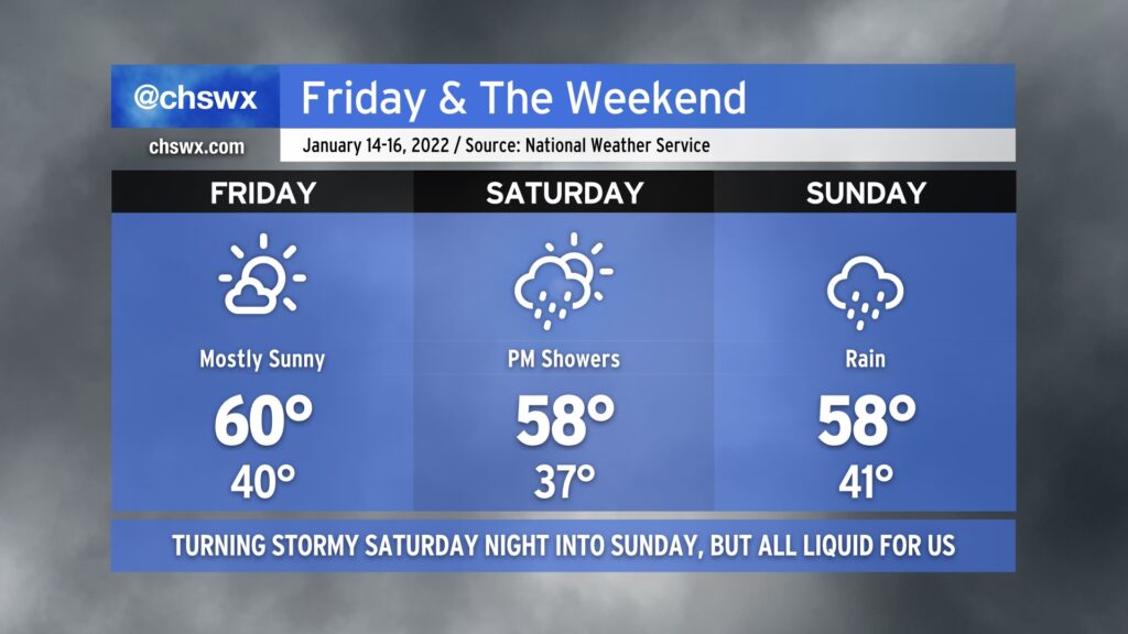
Let’s start with the good news: Friday looks pretty good, with highs around 60° in the afternoon under mostly sunny skies. Much of Saturday looks to be okay as well, with showers not expected to start until later in the afternoon/early evening. And then there’s Sunday.
Sunday is the day we’ve had our eyes on for a while, and we’re now at the point where we can start to dig into the details with more confidence. First, and most importantly, winter weather stays north and west of the Charleston metro area. This is anticipated to be a liquid-only event for the Lowcountry. There could be quite a bit of that liquid, too, with 1-2” of rain possible before it’s all said and done given copious amounts of moisture for mid-January getting into place.
Winds will be capable of gusting 20-30 MPH as low pressure deepens and makes a close approach Sunday afternoon. There’s still some question as to exactly where the low will track, but at this point that should not be enough — barring a much more southward shift, which appears highly unlikely — to pull enough cold air into the area for any wintry precipitation. The track of the low will also have significant effects on water levels in the harbor, with the potential for some minor coastal flooding if the low stays more to the south for longer, allowing east and northeasterly winds on the north side of said low to have some residence time and push water levels higher.
Temperatures are going to be a challenge on Sunday. A sharp gradient will exist across the area, with high temperatures approaching the 60s near the coast where a warm front will lie. Further inland into Berkeley and Dorchester counties (especially near I-95), temperatures will run about 5-10° cooler, and this could still be optimistic depending on how strong a wedge of high pressure ultimately gets.
It remains to be seen if enough instability can develop for some thunder. Right now, that is not in the NWS forecast, but it is worth watching especially if the warm sector can penetrate a little further inland than the model consensus currently indicates. That seems unlikely, though, given plenty of rain falling into the wedge of high pressure to the north, which will act to reinforce the cooler air. Thus, right now the severe weather risk is low, but as additional data comes in over the next couple days, we’ll watch this wrinkle carefully.
Have travel plans to the Midlands, Upstate, or the piedmont of North Carolina? Be very careful especially Saturday night into Sunday as freezing rain looks to be a decent threat especially north of I-20. Icy roads are certainly a possibility. The best risk for snow will be found in the Blue Ridge, where a half-foot or more of snow is certainly possible.
Stay tuned to forecast updates as the details will undoubtedly continue to evolve throughout the weekend with more higher-resolution guidance helping to fine-tune things.