The week ahead: A bit quieter, but below-normal temperatures continue
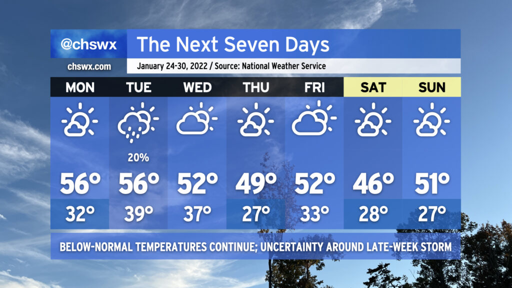
Overall, the forecast is looking a bit quieter (at least right now) as we head into the final full week of January (yes, already). Below-normal temperatures (normal highs for late January are around 60°) will continue as the overall pattern continues to show a ridge in the west and a trough in the east, keeping this side of the country in cooler temperatures and in a more active storm track overall.
Monday looks to be a repeat of today without the 21° start or the falling ice onto the Ravenel Bridge. We’ll start the day again around freezing, but that will be fairly short-lived as temperatures will top out in the mid-50s under mostly sunny skies. Low pressure sliding south of the area could toss some moisture in play on Tuesday with a slight shower chance across the area, but temperatures will remain above freezing. We run a little cooler Wednesday and again on Thursday as a front comes by, with another hard freeze possible overnight Wednesday into Thursday.
By Friday, the forecast becomes a bit more uncertain as we watch for an area of low pressure that looks to develop off the coast of Florida and move northeastward. The global models are pretty far apart on the position of a trough that would push the low further offshore. Right now the ECMWF (Euro) solution favors a dry forecast for us, while the GFS has been slower on the trough and thus keeps the low a little more eastward, spreading some precipitation ashore. We’ll wait to see how things develop, but for now, NWS has kept the area rain-free as we head into Friday and the weekend, which will continue to be significantly cooler than normal. Right now, the forecast shows mornings in the 20s and highs in the mid-40s on Saturday and low 50s on Sunday with generally quiet weather. Stay tuned for changes here, though.
Have a great week!