The week ahead: Cooler-than-normal temperatures abruptly give way to warmth and unsettledness
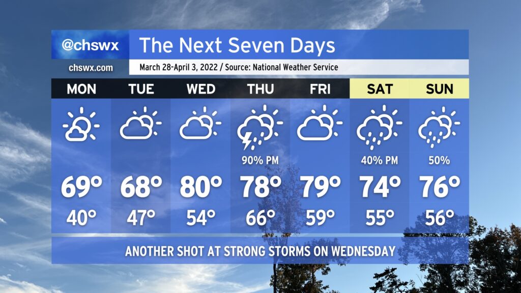
We’ve got a day or two more of chilly weather (for late March, anyway) before temperatures rise quickly on Wednesday as a storm system approaches the area. From there, a stalled front provides additional opportunities for rainfall over the weekend.
Our stretch of cool and fair weather continues into Monday at a minimum. There will be actual clouds in the sky on Monday, generally of the high variety as a little moisture squeezes out around the base of the trough that’s brought us this very chilly weekend. Temperatures will remain on the cool side, bottoming out in the 40s in the metro area and perhaps the mid-30s in more rural areas, prompting a Frost Advisory for Inland Berkeley County.
A warm front will approach the area on Tuesday, allowing for more cloud cover to develop. It’s not clear just how far north said front might get yet; the current forecast is for temperatures to once again top out in the upper 60s, but it’s possible that the afternoon could run a touch warmer if the front is able to make a little more headway.
Wednesday will offer one more rain-free day before the storm system gets into the area. By then, the warm front will have lifted north of us, with highs in the upper 70s to low 80s running in stark contrast to what we’ve experienced over the past few days.
The next appreciable rain chance arrives Thursday afternoon and evening with a cold front; rainfall looks likely with some rumbles of thunder, but the higher severe weather risk is displaced to the north with the better dynamics. We’ll get a break in the rain on Friday, but with the front stalling out to our southwest, shower and storm chances remain in the picture through the weekend. Temperatures, meanwhile, will remain a little above normal.