The week ahead: Summer returns — rain, not so much
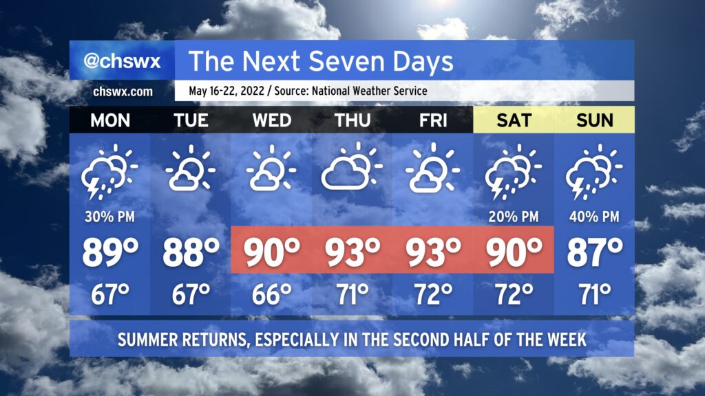
Summer’s back this week as above-normal temperatures once again take root across the area thanks to high pressure and dry air precluding much in the way of thunderstorm formation for a majority of the week.
Monday afternoon offers the best shot at a shower or thunderstorm — albeit at around a 30% probability — as a cold front approaches the area and stalls out. A storm or two could be on the strong side with damaging wind gusts and large hail possible., but the vast majority of us won’t see severe weather, and a good bit of us may not even see much in the way of rain — unwelcome news for a still-parched Lowcountry.
The aforementioned front stalls out Tuesday and lingers in the area through Wednesday. Drier air, though, is going to keep rain chances squelched for the most part. Once the front lifts back north as a warm front and high pressure builds back from the west Wednesday into Thursday, temperatures will start to respond by heading into the low to even mid-90s in some spots, especially Thursday and Friday. Meanwhile, rain chances are held to a whimper.
High pressure starts to loosen its grip over the weekend, and afternoon thunderstorm chances start to tick up as a result (though isolated to scattered coverage is expected at best). Highs will continue to run above normal in the low 90s on Saturday before moderating slightly back to the upper 80s on Sunday.
For now, though, keep on watering and feel free to get your car washed, because Mother Nature’s going to be of little to no help in that department for at least the next week.