The week ahead: A hot and humid start to August
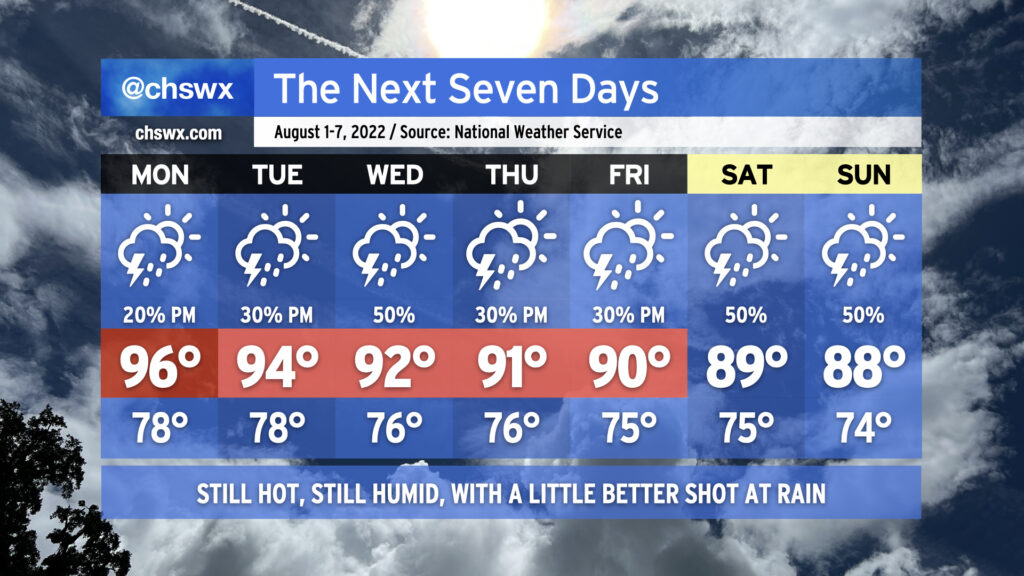
We say goodbye to July and hello to August with appropriately hot and humid conditions for this point in the summer, though we’ll see air temperatures fall a bit as the week progresses, which will have a little downward pressure on heat indices primarily as we get into the weekend. We have some rain chances in there as well, particularly mid-week.
Monday will be the hottest day air temperature-wise as highs look to peak in the mid-90s, though some drier air aloft will mix down and bring dewpoints to around 70° in the metro area, keeping heat indices in check to around 100-103°. An afternoon shower or storm can’t be ruled out, but coverage should be sparse.
Tuesday could see a little more convective coverage as high pressure aloft begins to shunt southward a little, while Wednesday should be even a little more active as a trough approaches from the southwest and return flow from the Gulf establishes itself nicely with Atlantic high pressure retrograding eastward. Thursday and Friday feature more typical afternoon thunderstorm chances. Highs in this period will steadily head down, ranging from 94° on Tuesday to 90° on Friday. However, the infusion of humidity will keep heat indices in the low 100s through Thursday despite the lowering air temperatures.
Temperatures will continue to fall into the weekend, with highs stopping short of 90° expected Saturday and Sunday thanks to a little more in the way of onshore flow as Atlantic high pressure shifts a little more northward. This could also keep rain chances a touch higher, as well, but no washout is currently in the cards for the weekend. Overall, pretty standard early-August fare for the Charleston metro area.