The week ahead: More seasonable temperatures for Thanksgiving week with a few showers at times
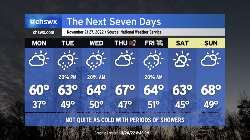
If you weren’t a huge fan of the winter-like chill that shaped the past week’s weather, here comes a somewhat more seasonable feel to the air for Thanksgiving week. (We’ll also have some showers and some tidal flooding to come along for the ride.)
Monday morning will be the last morning in the 30s for a little bit. The clearing thick high cloud cover will allow for some decent radiational cooling inland; lows could dip to around freezing well inland (closer to I-95) while temperatures bottom out in the mid-40s closer to the coast. We should see a fair bit of sunshine on Monday before some low-to-mid-level clouds develop. Expect temperatures to rebound to about 60° in the afternoon.
Tuesday starts out quite a bit warmer, with lows around 50° as cloud cover increases with moisture encroaching from the south. Mid-level energy should help to spawn some showers by Tuesday evening, lasting roughly through Wednesday morning. High temperatures will run in the low-to-mid-60s.
Thanksgiving Day looks pretty seasonable, with lows in the mid-40s yielding to highs in the mid-to-upper 60s, right around normal for this point in the year. Expect a mix of sun and clouds as we sit between storm systems.
Model solutions diverge pretty sharply for Friday, with pretty stark differences in the speed and position of the next storm system between the global models. The GFS has surface low pressure back in the mid-South, while the ECMWF has surface low pressure moving up the mid-Atlantic as a cold front clears the area, among other timing differences. We’ll want to keep an eye on this for late week as the forecast will almost certainly need refinement here.
On the current NWS forecast, rain clears the area for the weekend, yielding pretty nice conditions overall for outdoor activities. Highs top out in the low-to-mid-60s Saturday, while Sunday could feature highs approaching 70°.
Coastal flooding risk ticks up starting Tuesday
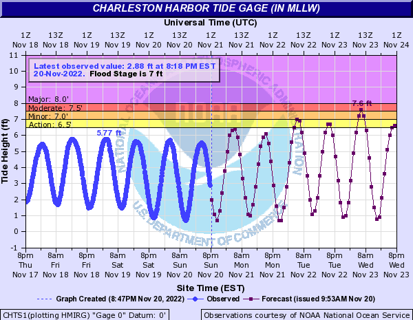
The upcoming new moon and northeasterly winds will bring about another round of coastal flooding with morning high tides starting Tuesday and likely lasting through the rest of the week. Minor coastal flooding appears possible around the 6:10am high tide Tuesday, with moderate flooding forecasted with Wednesday morning’s high tide, predicted to peak just shy of 7am. Guidance suggests moderate flooding with morning high tides will continue into Thursday, which could be the peak of the event. On the current forecast, Friday’s winds should turn more westerly and thus less favorable for coastal flooding, but we’ll need to keep an eye on this as a slower solution with low pressure and the associated cold front would give us another day of onshore trajectories.
Follow my Charleston Weather updates on Mastodon, Bluesky, Instagram, Facebook, or directly in a feed reader. Do you like what you see here? Please consider supporting my independent, hype-averse weather journalism and become a supporter on Patreon for a broader look at all things #chswx!