A few showers possible Tuesday
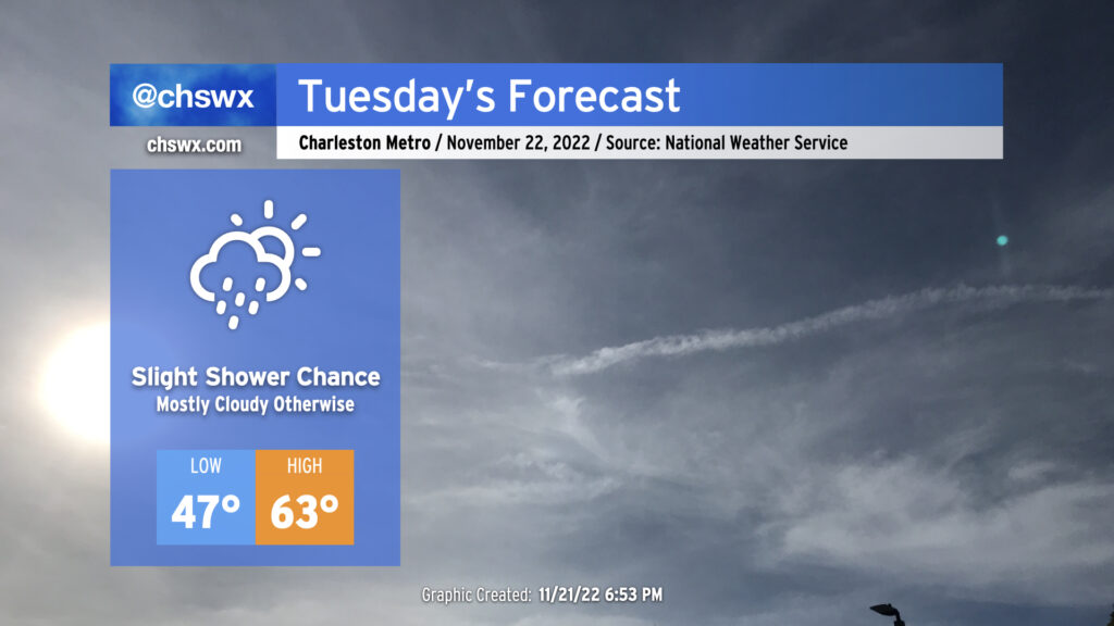
Cloud cover moving over the area tonight will make for a much warmer start to Tuesday than we saw on Monday, with lows only dipping into the mid to upper 40s. Wakeups will trend even warmer as we get into the rest of the week, with lows in the 50s becoming commonplace through the weekend.
Keep an eye out for a few showers during the day on Tuesday as a coastal trough develops. Otherwise, expect temperatures to top out in the low 60s under mostly cloudy skies.
There will be a risk for a little salt water encroaching on roads around Gadsden Creek (Hagood/Fishburne/Lockwood) around the 6:10am high tide, but more significant flooding is not expected as water levels are expected to peak just shy of the 7′ coastal flooding threshold in Charleston Harbor.
Thanksgiving forecast: Periods of showers, seasonably warm, tidal flooding each morning
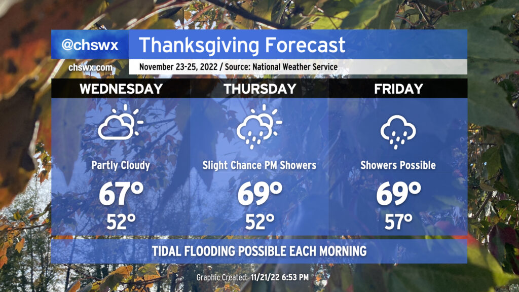
As we head into the Thanksgiving travel period, temperatures will continue to warm across the area. Expect lows in the low 50s Wednesday and Thursday, with upper 50s for lows on Friday. Highs, meanwhile, will top out in the upper 60s each day, generally right around if not slightly above mid-late November norms.
Wednesday looks to remain rain-free, with decreasing clouds as a coastal trough moves away during the day. A few showers may be possible later Thursday, but the vast majority of us right now look to stay dry.
Getting into Friday, model timing differences remain around where a mid-level low will end up across the Southeast, with implications for a surface low and associated cold front and thus timing for rainfall. The general thinking goes like this: A surface trough or warm front should lift north across the area on Friday, eroding a wedge of high pressure and bringing scattered showers to the area as more warm and humid air moves northward. (A thunderstorm isn’t out of the question, either.) From there, a surface low pressure system and its associated front will move northeast across the area, following the mid-level low, likely generating another round of rain on Saturday. There are questions on how fast the rain gets out of here, with a nonzero possibility that it lingers into Sunday morning if the GFS solution pans out. Bottom line: Keep an eye on forecasts if you have travel plans this weekend as rain could put a bit of a damper on travel, especially heading home along the East Coast Saturday into Sunday.
Moderate coastal flooding possible Wednesday-Friday
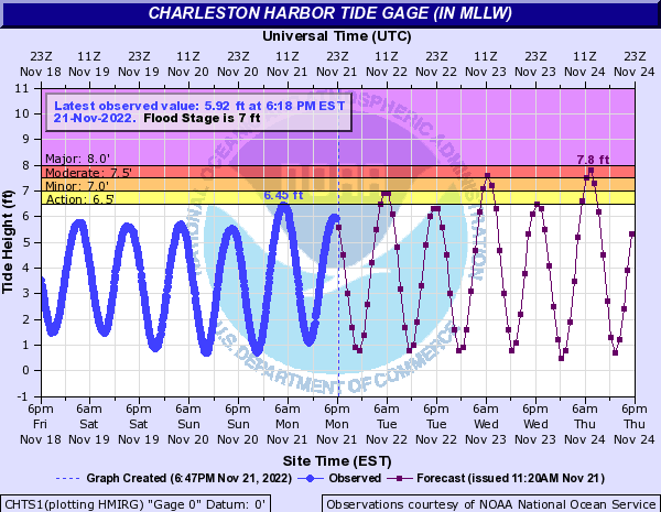
Strengthening northeasterly winds around a wedge of high pressure and Wednesday’s new moon will combine to drive water levels well into moderate coastal flood threshold around times of high tide each morning Wednesday through Friday. Water levels should peak around 7.6′ with high tide just shy of 7am on Wednesday, while a 7.7-7.9′ high tide is expected around 8am Thursday. Thursday’s peak in particular should be enough to cause scattered to numerous road closures in downtown Charleston. Guidance suggests similar water level heights will be possible on Friday, too. If downtown is in your travel plans late this week, be ready to reroute around flooded roads during the mornings.
Follow my Charleston Weather updates on Mastodon, Bluesky, Instagram, Facebook, or directly in a feed reader. Do you like what you see here? Please consider supporting my independent, hype-averse weather journalism and become a supporter on Patreon for a broader look at all things #chswx!