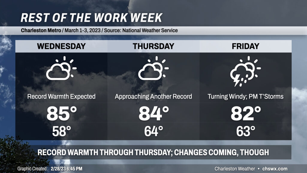
Rest of the work week: Record books remain under siege, but changes are coming
February — and meteorological “winter” — will close on an abnormally warm note. Today’s high of 86° at the airport tied the record high first set in 1962. This stretch of record warmth looks to continue as we kick off March and meteorological spring, but there are signs that cooler weather is on the horizon, both this weekend and in the longer term.
Wednesday and Thursday: More record highs threatened
NWS is explicitly forecasting a record high on Wednesday, with a high of 85° expected in the afternoon despite a little bit more in the way of mid-to-high-level cloud cover. If the forecast verifies, the current March 1 record high of 83° set in 2017 would fall handily. It’s also expected that the record high of 79° at downtown Charleston is expected to fall as well, though the seabreeze shouldn’t be as pinned as it was today. A more southwesterly wind will send dewpoints higher, making for a more muggy feel to the air than we saw Tuesday.
We will get close to another record high on Thursday, too: the forecast high of 84° is just one degree off the record of 85° set in 1997. Southwesterly winds will continue that feed of moisture into the area, with mid-60s dewpoints building ahead of a cold front that will approach the area Friday.
Friday: Cold front approaches, turning quite windy
Friday will represent the last really warm day of this two-week stretch as a potent storm system moves into the Ohio Valley with a trailing cold front that will sweep across the area overnight Friday. This has the potential to be a real wind-maker for us, with gusts over 40 MPH not out of the question regardless of whether storms fire or not. Highs should top out in the upper 70s to low 80s.
What’s less clear for Friday is the risk for precipitation and severe thunderstorms. Forecast soundings continue to show a fairly decent lid on the atmosphere for much of the day, which will keep a lot of Friday rain-free. Lifting along the front should be enough to trigger some gusty showers later in the day, but it’s less clear if it will be enough to kick off thunderstorms. Generally speaking, it looks as if the better instability will reside inland, waning over time as daytime heating is lost. Shear is looking pretty good, and if storms can get going, it won’t take much to get some sporadic wind damage reports given a very strong low-level jet on the order of 50-60 knots. Still wait-and-see on this, but the general model consensus is that while a severe storm or two could be possible, it looks like the better risk for that will be to our west. Stay tuned for forecast updates as we get closer to Friday.
Cooling down a bit this weekend
The front swings through overnight Friday into Saturday, sending winds back around to the west. Cooler air lags a bit, though, and we’ll run into the upper 70s again on Saturday. Sunday, though, will feature much cooler and drier air, and highs will only top out in the low 70s. 70s look to continue into the first part of next week — still above normal, but certainly not in the realm of abnormal that we’ve felt in the last couple weeks.
Even cooler weather could yet be on the horizon: the Climate Prediction Center outlook is for below-normal temperatures in the mid-March timeframe. Climatologically speaking, the last freeze date generally averages from early March along the coast to mid-March further inland, so there’s still very much of a risk that these last couple weeks could represent a false start to the growing season. To that end, Frost and Freeze products from the National Weather Service will resume March 1, alerting agricultural and horticultural interests to the potential for killing freezes.
Follow my Charleston Weather updates on Mastodon, Bluesky, Instagram, Facebook, or directly in a feed reader. Do you like what you see here? Please consider supporting my independent, hype-averse weather journalism and become a supporter on Patreon for a broader look at all things #chswx!