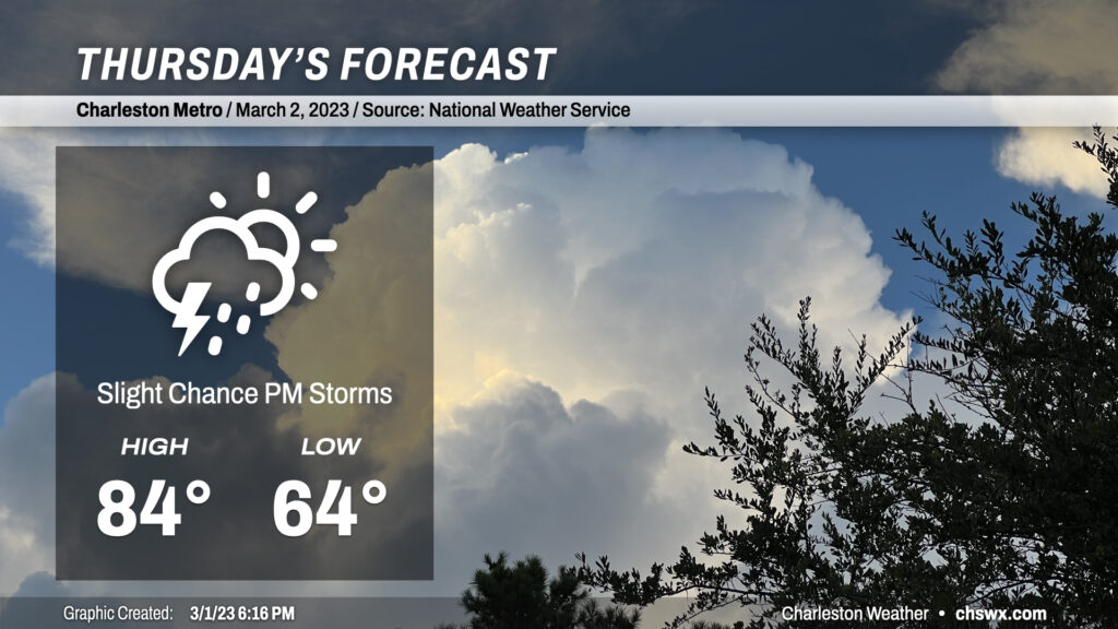
Thursday: One last day of record-challenging warmth
We had another record warm day in the Lowcountry today. The high at the airport reached 86°, breaking the record of 83° set in 2017. Despite the seabreeze making more of an inroads today, Downtown Charleston appears to have tied its record high as well, topping out at 79° to match the mark on March 1, 1918.
We will have one more day of record-challenging temperatures on Thursday before some of the extreme warmth begins to subside. Highs should top out once again in the mid-80s, getting within spitting distance of the record high of 85° set in 1997. This is despite some additional cloud cover and perhaps a few showers and maybe a thunderstorm in the afternoon and evening hours as southwesterly winds ahead of a cold front continue to strengthen across the area. Most of us will get the day in rain-free, though, with the better risk of showers and storms to our north near a frontal boundary. (This might or might not be such a great thing considering the absolute onslaught of pollen that continues across the Lowcountry!)
Friday & the weekend: Changes on the way as a series of fronts affect the area
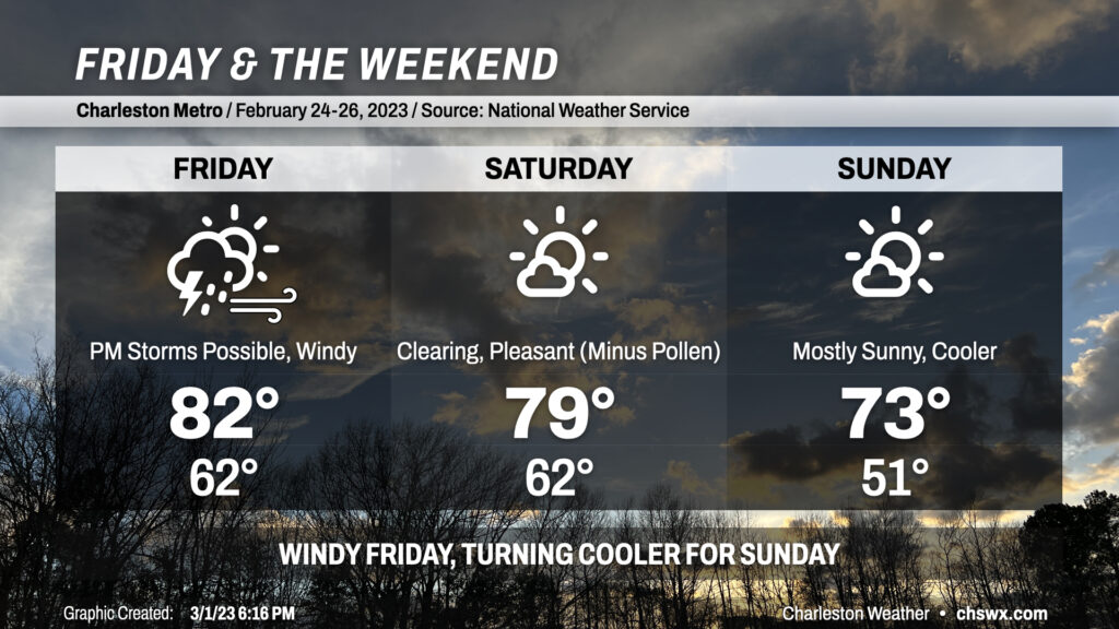
The first in a series of cold fronts to affect the area for the weekend approaches the area on Friday, accompanied by an intensifying mid-level low moving into the Ohio Valley. Wind fields with this system are really impressive, with the potential for wind gusts in the 30-40 MPH range across much of the area outside of thunderstorms as temperatures warm into the low 80s and the resulting mixed layer taps into a 50-60 knot low-level jet.
Attention will then turn to the threat for severe weather as the front gets closer to the area in the evening. As mentioned earlier, the wind field is solid, with more than enough wind shear to help organize thunderstorms. The big question is going to be available instability and if there’s even enough moisture for much in the way of storms, especially as the front arrives as daytime heating wanes. Given the strong wind fields, it may not take much to pull a damaging gust or two down, but the overall elevated nature of the instability and a persistent capping inversion certainly will seem to stymie much in the way of shower or thunderstorm development. As the parent low ejects into the Mid-Atlantic, the trailing front will become weaker this far south as well, adding another question mark to any severe threat. Still, we’ll want to watch the wind fields and how the convection-allowing models evolve on this over the next day or so — subtle changes in available instability or moisture could have big effects on the weather we end up experiencing.
The first front crosses the area overnight Friday/early Saturday morning. There won’t be too much of a noticeable airmass change with it; we’ll still top out near 80° on Saturday after starting in the low 60s with a few clouds from time to time. A secondary front will make a dry passage late Saturday, and this is the one that will finally cool things down a little bit heading into Sunday. Expect to start Sunday in the low 50s, with highs topping out in the low 70s under mostly sunny skies. Aside from the pollen, it will be a nice weekend to do some things outdoors, especially on Sunday with temperatures running a little on the cooler side.
A very warm February (and meteorological winter) comes to a close
We have closed the books on a very, very warm February — the second-warmest on record — and on meteorological winter as a whole. For meteorologists and climatologists, winter runs from December 1 to the end of February to allow for comparisons over time. And what a “winter” it was in the Lowcountry — the third-warmest on record with an average temperature of 56.4°. (And yes, this does take into account that frigid snap in December, which makes the warmth all the more remarkable.)
Here’s how the numbers landed:
Warmest winters on record by average temperature at North Charleston
- 1948-1949: 57.0°
- 2016-2017: 56.9°
- 2022-2023: 56.4°
- 1949-1950: 56.1°
- 1973-1974: 54.9°
Warmest Februarys on record at North Charleston
- 2018: 62.0°
- 2023: 61.5°
- 2017: 59.4°
- 1990: 59.2°
- 1949: 58.4°
Miscellany
- Fifth-warmest January on record with an average temperature of 55.7°
- February 2023 was only the fifth time since records began in 1938 without a freezing-or-below temperature at North Charleston in the month of February, and first since 2018 (lowest temperature was 33° on February 4)
- We came within a degree of the warmest February high on record (87°) on February 24th and 28th, when temperatures topped out at 86°
Do not let the warmth of these past couple months fool you, though: March often comes with one more freeze up its sleeve, and the pattern looks favorable for below-normal temperatures in mid-to-late March. Don’t plant anything sensitive just yet, and if you have sensitive vegetation taking off, keep an ear out for frost and freeze advisories from the National Weather Service to know when to protect those plants.
Follow my Charleston Weather updates on Mastodon, Bluesky, Instagram, Facebook, or directly in a feed reader. Do you like what you see here? Please consider supporting my independent, hype-averse weather journalism and become a supporter on Patreon for a broader look at all things #chswx!