Rest of the work week: A much different feel to the air
Today’s high was 87°, breaking the record of 86° set in 1961 while also being the warmest day of the year so far in 2023. Downtown got in on the record warmth action, too: the high of 84° broke the record of 83° set in 1945 and tied in 1961.
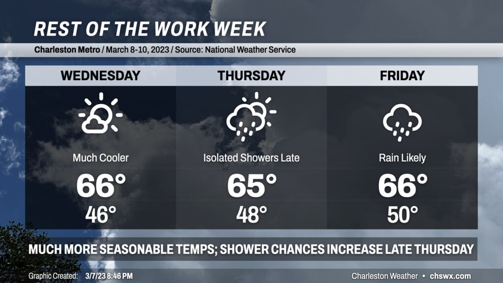
This changes drastically starting Wednesday. Lows in the 60s turn into lows in the mid-40s; highs in the 80s drop off 20°+ to the mid-60s in the wake of a front that is ushering in some much more seasonable — if not slightly below normal — temperatures for this point in the year. Winds may be gusty overnight as the cooler air moves in, and we’ll stay a little breezy through a good bit of Wednesday. The ongoing cool advection will counteract the otherwise mostly sunny skies to yield those mid-60s highs.
Clouds will be on the increase Thursday ahead of a storm system that’ll be organizing in the mid-South and heading eastward. We could see some showers as early as Thursday evening, but the best chance for rain arrives Friday as the storm system and its associated cold front move through the area. Highs both days will remain in the mid-60s as we look to stay primarily in the cool sector of this particular storm.
Looking ahead to the weekend, Saturday so far is looking pretty good, but Sunday might be tricky with some afternoon/evening showers possible. Saturday will briefly bring highs back into the low 70s, while we’ll run cooler (mid-upper 60s) with more cloud cover Sunday.
Follow my Charleston Weather updates on Mastodon, Bluesky, Instagram, Facebook, or directly in a feed reader. Do you like what you see here? Please consider supporting my independent, hype-averse weather journalism and become a supporter on Patreon for a broader look at all things #chswx!