The week ahead: Warming up, then turning unsettled

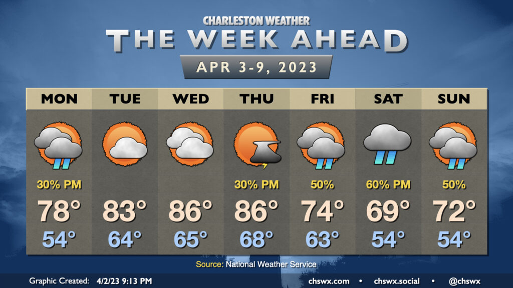
The week ahead will start fairly quiet and warm before turning more unsettled for the second half into the weekend as a cold front stalls nearby.
Cloud cover will be increasing on Monday as a trough moves by the area. This trough may be vigorous enough to squeeze out a few showers in the afternoon and early evening hours, so don’t be surprised to see a little rain on Monday as a result. Temperatures will start in the mid-50s and rise into the upper 70s away from the locally cooler coastline with a mix of sun and clouds outside of showers.
The 80s return Tuesday and stick around for the middle of the week. We stay rain-free Tuesday and Wednesday as a ridge builds overhead, sending highs from the low 80s on Tuesday to solidly in the mid-80s for Wednesday.
Thunderstorms return to the forecast picture Thursday afternoon as a front struggles its way to our neck of the woods. It’ll eventually get through, but will stall out nearby, cooling us off significantly in the process. Waves of energy aloft will help stir up showers at times starting Friday and into the weekend, and these showers and a developing high pressure wedge will suppress temperatures into the mid-70s on Friday. We may not even crack 70° on Saturday depending on shower coverage, and Sunday will remain on the cool side with highs in the low 70s and a continued risk for scattered showers. Fortunately, it doesn’t look like we have any concerns for severe weather this week as the energy that will drive another large-scale severe weather outbreak on Tuesday throughout the Mississippi Valley will be deflected well northward by the ridge that’ll take hold across our area.
Follow my Charleston Weather updates on Mastodon, Bluesky, Instagram, Facebook, or directly in a feed reader. Do you like what you see here? Please consider supporting my independent, hype-averse weather journalism and become a supporter on Patreon for a broader look at all things #chswx!