The week ahead: Windy start to May
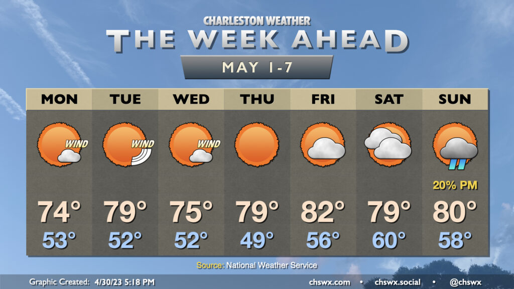
May will be getting off to a fairly windy start as a tight pressure gradient features prominently across the Southeast to start the work week. (At least we get comfortable temperatures and sunny skies!)
A secondary cold front will come through overnight, leaving us with lows in the low 50s on Monday morning. Despite nearly uninterrupted sunshine, highs only get to about the mid-70s in the afternoon with persistent cool advection and the aforementioned gusty winds. Watch for gusts approaching 30-35 MPH at times, with the higher end of these gusts more likely on the bridges. (Wind advisory criteria is 40 MPH, and we look to stay below that for the most part.) Gusts will die down as daytime heating is lost.
We start Tuesday in the low 50s once again before warming up into the upper 70s. Gusty winds will again play a role during the day, and we may once again see gusts in excess of 30 MPH. On the very bright side, the sun will be unencumbered and temperatures will be comfortable with low humidity.
We’ll have one more breezy day Wednesday with gusts approaching 25 MPH, but it doesn’t look like it’ll be as windy as it was to start the week. An overnight, dry cold front will knock highs down a peg into the mid-70s. A warming trend then establishes for Thursday and Friday, with highs in the upper 70s and low 80s, respectively, as winds begin to turn back toward the southwest. Clouds increase for the weekend, but temperature will remain right around normal for this point in the year, with a slight chance of showers Sunday.
Follow my Charleston Weather updates on Mastodon, Bluesky, Instagram, Facebook, or directly in a feed reader. Do you like what you see here? Please consider supporting my independent, hype-averse weather journalism and become a supporter on Patreon for a broader look at all things #chswx!