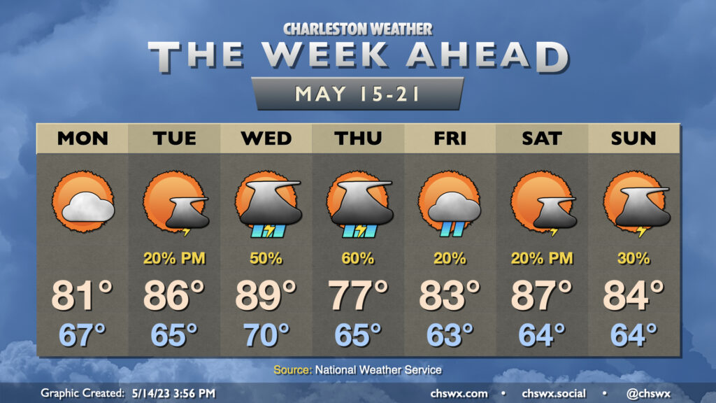
The week ahead: Unsettled at times

The week ahead will be unsettled at times as a ridge of high pressure to the west retreats, allowing mid-level impulses and another cold front to drive into the area to keep showers and storms in the forecast.
Monday looks to be a reasonably quiet day as a cold front stalls to our southwest and somewhat drier air punches in from the northeast. We’ll start the day on the warm side, with lows bottoming out in the mid-to-upper 60s. A few showers could linger in the morning, but the balance of the day should be rain-free under partly cloudy skies.
Quiet conditions should continue into much of Tuesday, though a few storms will be possible late in the day. Temperatures will warm back into the mid-80s. Isolated to scattered storms could persist overnight before another front pushes into the area during the day Wednesday. This should bring some more showers and storms to the area for the afternoon and evening hours. Provided the front doesn’t arrive a little earlier than currently forecast, highs could top out near 90° ahead of the front with a little compressional heating taking place.
A wedge of high pressure will build in behind the front, and this could provide a rainy Thursday with the risk of a couple thunderstorms as well. Temperatures will run 10°+ cooler as a result of the wedge pattern and expected rainfall. The wedge will erode Friday, yielding temperatures in the low 80s with only a slight chance of showers as clouds decrease throughout the day. As far as the weekend goes, Saturday looks to be the better of the two days so far with warm temperatures and only a slight chance of storms along the seabreeze in the afternoon. This morning’s global models are advertising a bit more unsettled weather Sunday as a cold front moves by, but run-to-run consistency has yet to be established. For now, scattered storms are the forecast with highs in the mid-80s. Stay tuned for updates.
Follow my Charleston Weather updates on Mastodon, Bluesky, Instagram, Facebook, or directly in a feed reader. Do you like what you see here? Please consider supporting my independent, hype-averse weather journalism and become a supporter on Patreon for a broader look at all things #chswx!