Tuesday: Warm before the rain
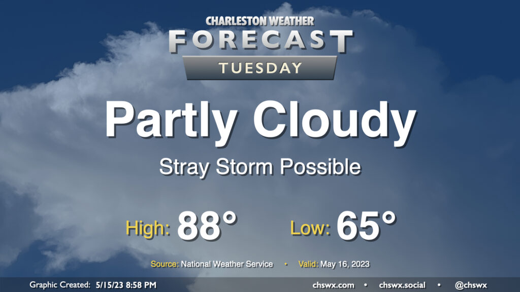
A warm front will lift north of the area tomorrow, bringing in even warmer and more humid air for Tuesday. Much of the day should stay rain-free with relatively weak instability, though a stray shower or storm near the seabreeze can’t be discounted. If a storm or two does form, note that storm motions will once again bring them toward the coast, so be aware of that if you have a Tuesday beach trip planned. (Lucky duck.) Expect highs to top out in the upper 80s; I wouldn’t be shocked to see a 90° reading somewhere, either.
Rest of the work week: Turning unsettled for a few days
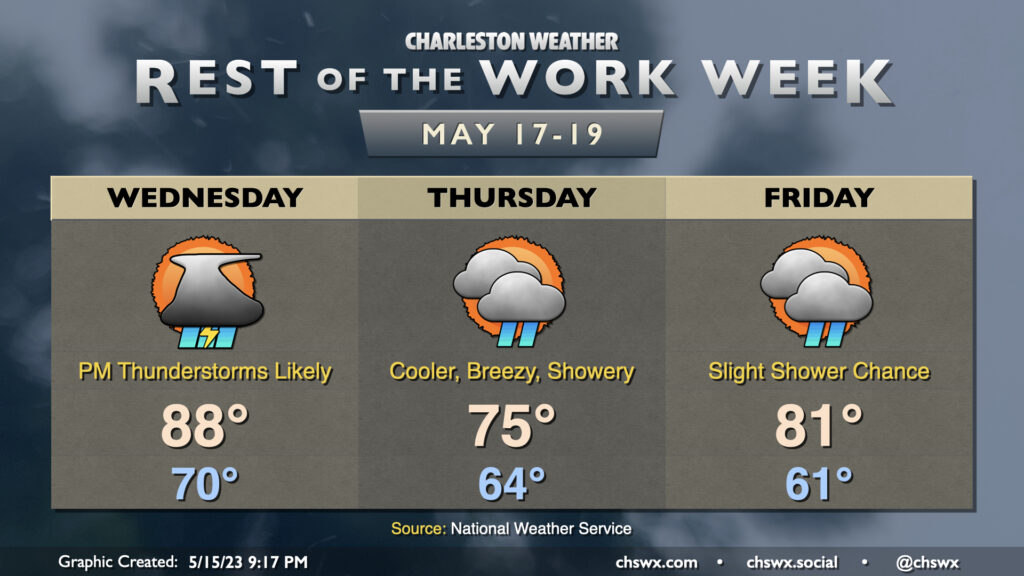
The second half of the work week will be on the unsettled side, particularly on Wednesday, as a cold front moves back into the area from the north. We’ll once again get off to a warm start, with lows bottoming out around 70° Highs should top out in the upper 80s before thunderstorms become more widespread in the afternoon. There is the risk for a stray shower in the morning, but as the front gets closer and the seabreeze gets going, that should change fairly quickly. Heavy rain will be possible within thunderstorms, and some minor flooding can’t be totally ruled out where storms set up. Severe weather is unlikely, but as you know and are probably sick of me saying, all thunderstorms are dangerous thanks to lightning.
Once the front gets through, high pressure wedges into the area for Thursday, turning temperatures considerably cooler — think mid-70s in the afternoon — with showers on and off throughout the day. No washout is expected, but you’ll want rain gear at times. Expect breezy northeast winds within the wedge as well; gusts could get near 25 MPH at times.
The wedge breaks down for Friday, allowing temperatures to warm back into the 80s after a cool start in the low 60s, but isolated to scattered showers remain possible throughout the day. We should see progressively more sunshine, though, as Friday wears on. Northeasterly winds will continue to be breezy, so be a little more mindful when driving over the bridges.
Follow my Charleston Weather updates on Mastodon, Bluesky, Instagram, Facebook, or directly in a feed reader. Do you like what you see here? Please consider supporting my independent, hype-averse weather journalism and become a supporter on Patreon for a broader look at all things #chswx!