Rest of the work week: Turning unsettled

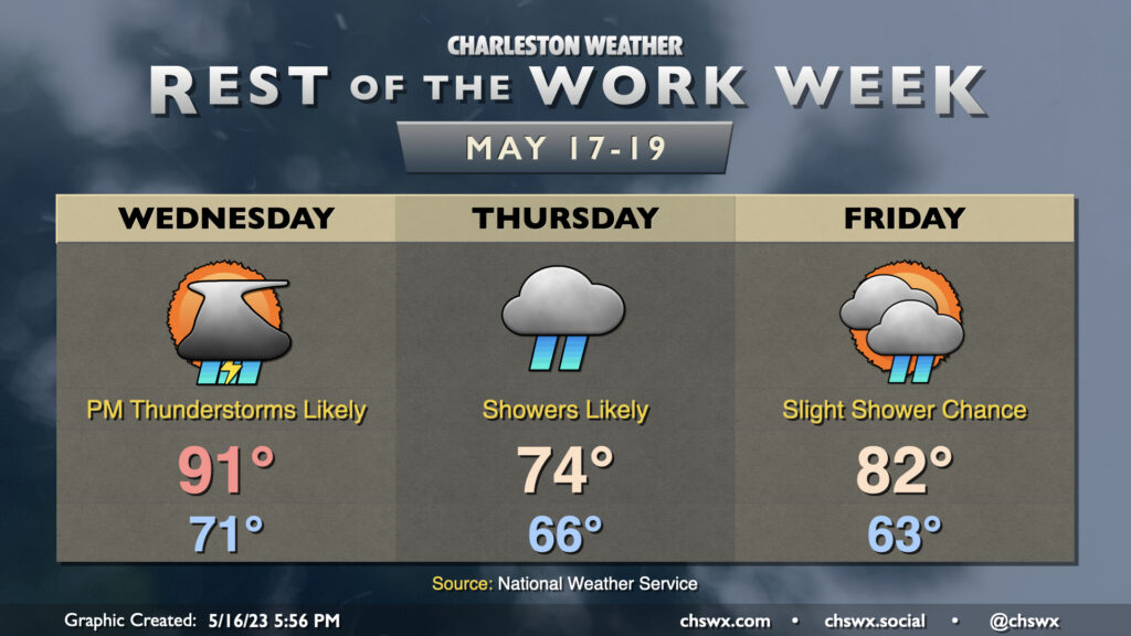
The rest of the work week will be on the unsettled side as a cold front moves back into the area from the north. Wednesday will, by far, be the warmest day of the set as highs top out in the low 90s before showers and thunderstorms initiate by mid-afternoon. Heavy rain will be possible within thunderstorms, and some minor flooding can’t be totally ruled out where storms set up. Severe weather is unlikely, but a sporadic damaging wind gust or two can’t be totally discounted.
Once the front gets through, high pressure wedges into the area for Thursday, turning temperatures considerably cooler — think mid-70s in the afternoon at best — with showers on and off throughout the day under generally overcast skies. A rumble of thunder can’t be totally ruled out, but is unlikely. Expect breezy northeast winds within the wedge as well; gusts could get near 25 MPH at times. This could drive tidal departures sufficient for minor coastal flooding Thursday evening with the 8:08 PM high tide.
The wedge breaks down for Friday, allowing temperatures to warm back into the 80s after a cool start in the low 60s. Low pressure will be riding up the coast; how fast this low moves will modulate our rain chances some, particularly near the coast. Right now, a few showers are possible, but it’s quite possible that much of us get Friday in rain-free. We should see progressively more sunshine, too, as Friday wears on. Northeasterly winds will continue to be on the breezy side in the morning, but will slacken as the pressure gradient relaxes.
Saturday should be mostly rain-free and on the warm side, but we’ll see rain chances tick back up for Sunday as another front affects the area.
Follow my Charleston Weather updates on Mastodon, Bluesky, Instagram, Facebook, or directly in a feed reader. Do you like what you see here? Please consider supporting my independent, hype-averse weather journalism and become a supporter on Patreon for a broader look at all things #chswx!