Rest of the work week: Abnormally cool weather continues
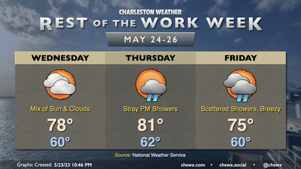
Our run of unusually cool late-May weather continues through the end of the work week as high pressure continues to wedge into the area from the northeast. Wednesday should look a fair bit like Tuesday did, but with even more dry air that should preclude any popup showers. After a seasonably cool start around 60°, highs look to top out in the upper 70s with a mix of sun and clouds with northeasterly winds around 5-10 MPH.
Winds turn a touch more onshore on Thursday as the wedge erodes inland a little bit in response to low pressure spinning up offshore, allowing a little more moisture to make it ashore and thus raise the specter of a few afternoon and evening showers. Even still, most of us get the day in rain-free. We’ll see a little warmer weather with highs topping out in the low 80s, but this is still well below normal for this point in the year.
The aforementioned low is the main forecast challenge heading into Friday and the weekend. If it takes a path closer to the coast, we could see higher shower chances as a result; if it moves further offshore, then that would drive those shower chances down. Regardless, the tightening pressure gradient will drive northeasterly winds a little higher, making for a breezy Friday (with this breeze continuing into the weekend). Highs on Friday will top out around 75°, about 10° below normal. (The record low maximum temperature of 66° for May 26 remains safe, though.) Stay tuned for forecast updates regarding the track of the aforementioned low pressure as tweaks will almost certainly be needed down the line.
Finally, the northeasterly winds will require us to keep watch on tidal departures. Water levels with the overnight high tides could get close to 7′, particularly on Friday and into Saturday. Keep an ear out for possible Coastal Flood Advisories from the National Weather Service (though, thankfully, these peak tides will arrive during off-peak hours).
Summer fans, you’ll get your due soon enough: A warming trend looks to begin Sunday, getting us flirting with 90° once again by next Tuesday.
Follow my Charleston Weather updates on Mastodon, Bluesky, Instagram, Facebook, or directly in a feed reader. Do you like what you see here? Please consider supporting my independent, hype-averse weather journalism and become a supporter on Patreon for a broader look at all things #chswx!