Sunday’s forecast: A sunny and warm June day

Sunday will be a much more traditional warm and somewhat muggy June day across the Lowcountry than we’ve felt for much of the month, really. We start the day in the low 70s before temperatures warm into the low 90s under mostly sunny skies. Kick in some humidity and it’ll feel closer to 95° in the afternoon at peak heating. It looks quite unlikely that a shower or storm will develop, though it can never be totally ruled out in the summertime. Suspect it’ll be another day full of Instagram stories from the beach. Use that sunscreen as the UV index will be a solid 10.
Strong to severe storms possible Monday

The break from unsettled weather will be fleeting as the risk for strong to severe storms returns to the forecast on Monday. A cold front running into a warm and unstable airmass with a trough rebuilding aloft should be enough to kick off scattered to numerous showers and thunderstorms in the afternoon and evening hours. The best risk for severe weather should be generally northeast of I-26, but everyone will have a chance for at least an isolated damaging wind gust. Stay tuned to forecast updates as things evolve, and be ready for Monday evening’s commute to be…well, interesting.
Tropical update: Bret dissipates, Cindy still a tropical storm
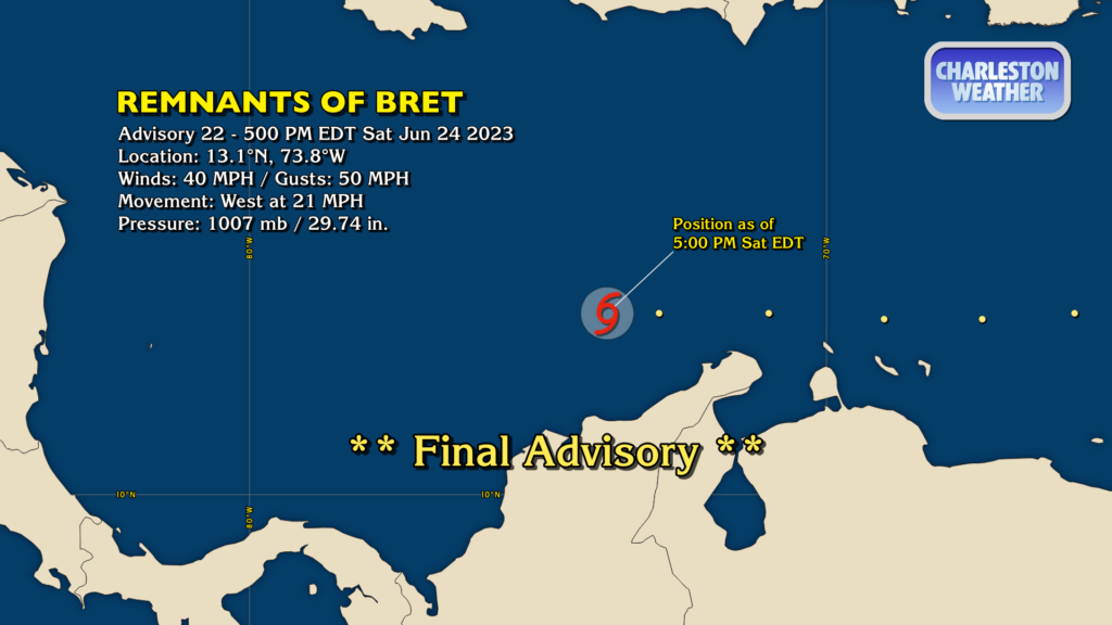
The National Hurricane Center has issued its final advisory on Bret, which has opened up into a wave as of the 5PM advisory Saturday and is no longer a tropical cyclone. Au revoir, Bret.
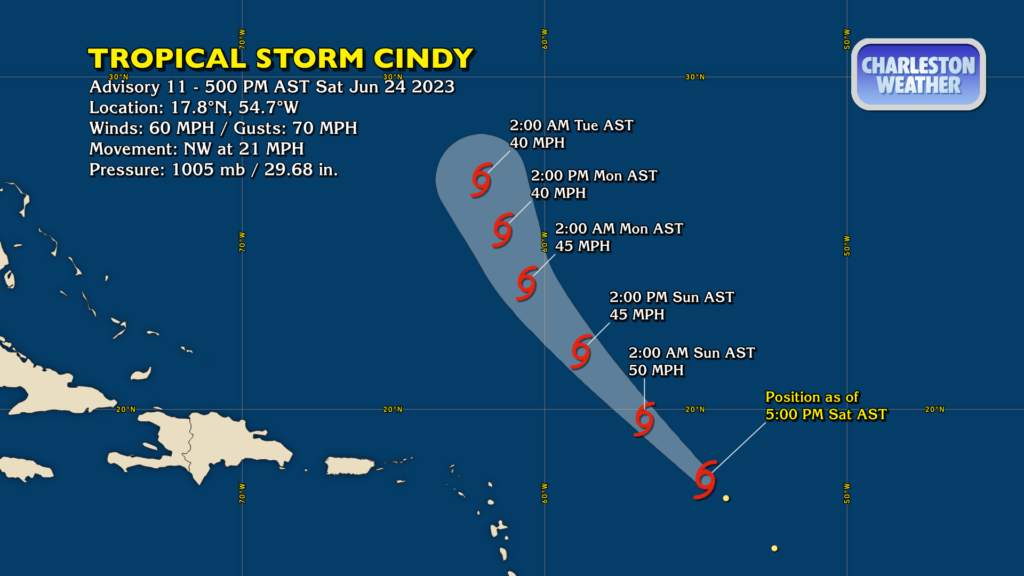
Tropical Storm Cindy, meanwhile, continues to move rapidly northwest around 21 MPH. It’s packing winds of 60 MPH with gusts to 70 as it moves through the open central Atlantic. It looks like Cindy’s strength is peaking as conditions gradually become more unfavorable for tropical cyclone maintenance. It will stay on the northwest path through the weekend, steering into a weakness in a high pressure ridge to Cindy’s east where it will encounter more wind shear and eventually dissipate by Tuesday. Cindy poses no threat to the Lowcountry.
Follow my Charleston Weather updates on Mastodon, Bluesky, Instagram, Facebook, or directly in a feed reader. Do you like what you see here? Please consider supporting my independent, hype-averse weather journalism and become a supporter on Patreon for a broader look at all things #chswx!