Sunday’s forecast: Scattered afternoon and evening storms as we watch TD 10

Sunday will be yet another warm and muggy late-August day across the Lowcountry. We’ll start the day in the mid-to-upper 70s before highs head to the low 90s in the afternoon. Heat indices should peak in the low 100s. From there, we should see a scattering of showers and thunderstorms along and ahead of the seabreeze. We may also see some activity from the north near a stalling cold front trying to infiltrate the area as well. The strongest storms will be capable of heavy rain and gusty winds, though widespread severe weather is far from in the cards. Overall, no washout of a day, just be ready to move outdoor activities inside if storms approach.
Tropical Depression Ten forms, should impact our weather mid-week
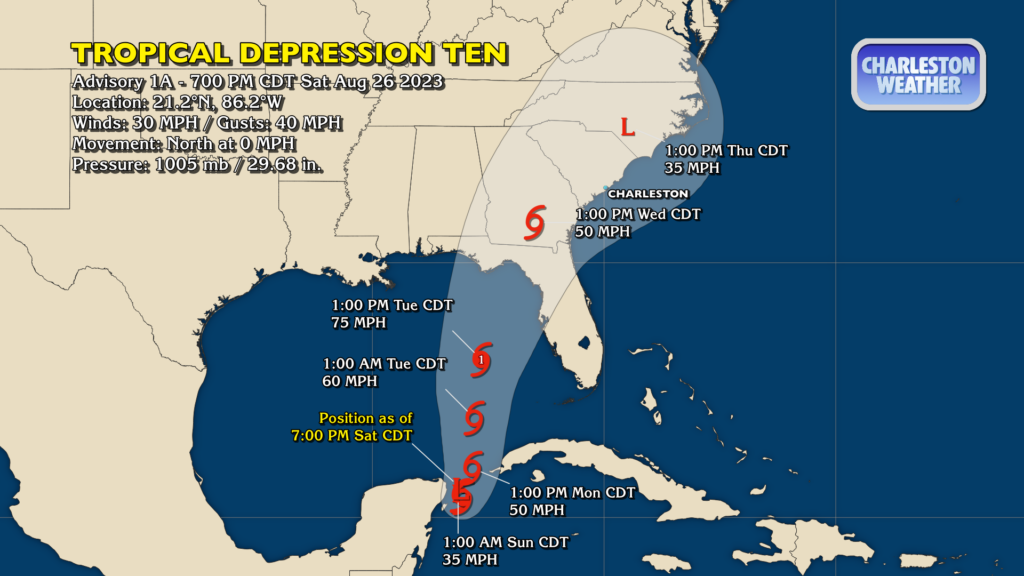
Tropical Depression Ten — likely to be named Idalia, perhaps as early as later tonight into Sunday — looks to have some impacts on our weather as we head into next week. The nature and magnitude of those impacts will largely be dependent on the track of the storm. The current NHC forecast takes Ten/future Idalia up into the Big Bend of the Florida Gulf Coast as a hurricane sometime Tuesday/Wednesday before the storm heads inland across Georgia and the Carolinas and weakens. Typically, a track across the Midlands tends to bring windy conditions at the coast, some beach erosion and coastal flooding (which will already be an issue given the full moon on Wednesday), and heavy rain. It’s probable, though, that we’ll see a lot of adjustments between now and then, so stay tuned for more fine-tuned information on impacts.
There remains so much uncertainty with the track guidance heading into mid-week. Once we can start to get Hurricane Hunter flights into the storm tomorrow to get higher-resolution data about the storm, we should start to see the models improve. NWS offices across the Southeast, including ours here in Charleston, are set to start releasing weather balloons every six hours starting at 2PM on Sunday. This additional data will help sample the strength of the ridge to the west and the trough in the east to further try to nail down the track, which will affect what and how much we ultimately get from this storm.
The bottom line with Ten right now is that we just need to keep an eye on forecast updates occasionally, because there will certainly be changes between now and mid-week. Stick to the official NHC forecast for your decision-making — it’s easy to get lost in models, which may or may not reflect reality. We in #chswx — wherever you get your weather — will keep you posted.
Follow my Charleston Weather updates on Mastodon, Bluesky, Instagram, Facebook, or directly in a feed reader. Do you like what you see here? Please consider supporting my independent, hype-averse weather journalism and become a supporter on Patreon for a broader look at all things #chswx!