Weekend forecast: Stormy at times, particularly Saturday

Showers and thunderstorms will be off and on throughout the weekend, particularly Saturday as a disturbance aloft ripples through the area. Winds turning onshore will bring some more moist air into the area, and we could see showers and thunderstorms begin to affect the area by daybreak. Some spots could see some fairly heavy rain at times, and a strong or severe storm isn’t totally out of the realm of possibility (though is rather unlikely). It won’t rain all day, but be ready to enact indoor plans on Saturday if necessary. Highs top out in the mid-to-upper 80s given the cloud cover and rain expected.
Storms should be a little more sparse coverage-wise throughout the day Sunday, though most of us should see at least some rainfall at some point throughout the day. Much like Saturday, the rain risk looks to start at the coast in the morning hours before shifting inland with the seabreeze in the afternoon. Once again, a storm or two could be strong, and some of the rain could be heavy at times, but widespread severe weather just doesn’t seem to be in the equation. Highs on Sunday run a click warmer, but still generally in the upper 80s.
Tropics: Lee encountering shear, will bring the surf up next week
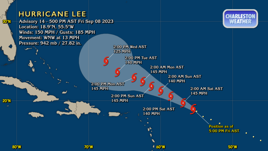
Hurricane Lee peaked at Category 5 intensity overnight Thursday into early Friday morning before southwesterly wind shear began to disrupt the storm somewhat, knocking it off its peak intensity, but it isn’t affecting the storm enough to weaken it that much — Lee remains a very powerful hurricane with max winds of 150 MPH as of Advisory 14, issued at 5PM on Friday. Thankfully, it continues to appear as if it will avoid direct impact with any land areas in the foreseeable future as it continues to move west-northwest into early next week before slowing up considerably to start the work week as steering currents weaken. From there, a turn more northward is expected, which is very likely to keep Lee off our shores. In fact, we are starting to see the expected turn being reflected in the NHC official forecast starting this evening — the 2PM Wednesday point gains a decent bit of latitude compared to its position Tuesday at 2PM. There remains considerable uncertainty at the long range, but guidance remains largely unanimous that a turn is going to occur, and that a turn would occur well enough offshore to keep us out of trouble with Lee. We need to continue to watch Lee’s progress to make sure it doesn’t misbehave, but I stress that aside from the surf and rip current risks, we really don’t have much to worry about with Lee as of right now. In the unlikely event that should change, I’ll let you know.
With computer models, caveat emptor
Remember, folks, the National Hurricane Center forecast is the one that should be informing your decisions around preparedness and overall life safety. Computer models are just one tool in the toolbox that the National Hurricane Center’s experts use to produce their forecast. Each model has its own strengths, weaknesses, idiosyncrasies, and the like, and it’s the forecaster’s job to understand this and apply the data accordingly. I promise you the Hurricane Center forecasters are not just copying and pasting their preferred model into the forecast — it very much is a blended approach involving not only computer guidance but also rigorous training and a lot of experience and research as well. Lean on their forecasts, and don’t get worked up with raw computer model output. There’s a reason their forecast is the standard, after all. </rant>
Follow my Charleston Weather updates on Mastodon, Bluesky, Instagram, Facebook, or directly in a feed reader. Do you like what you see here? Please consider supporting my independent, hype-averse weather journalism and become a supporter on Patreon for a broader look at all things #chswx!