Sunday: A few scattered storms, but not a rainout

Sunday should have a similar flair to Saturday with scattered storms and sunshine mixing in afterward. Like Saturday, we could see a few storms possible in the morning before gradually pushing inland during the day. And like Saturday, we should also see some decent sunshine kick in as well, with highs approaching 90° in the afternoon. Overall, not expecting a full rainout anywhere, but a few spots could see some heavy downpours with a quick inch of rain or so possible (much like parts of West Ashley and North Charleston saw this morning!)
Tropics: Lee hangs in against shear

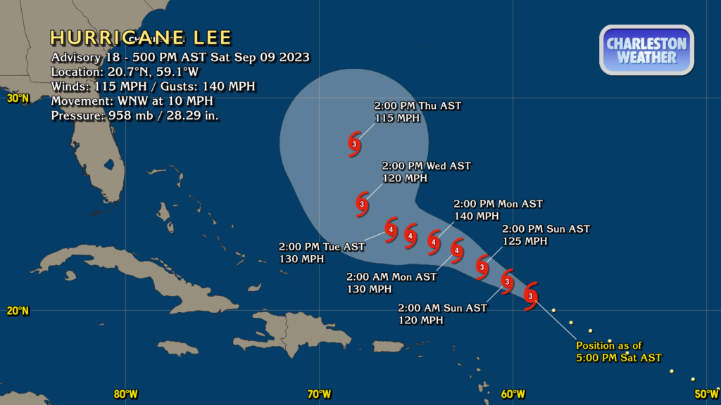
Hurricane Lee is hanging on in the face of southwesterly shear helping to wrap some dry air into the circulation. Despite this atmospheric hostility, Lee continues to maintain max wind speeds of around 115 MPH, good for Category 3 on the Saffir-Simpson Wind Scale. NHC expects this shear to relax and some intensification to resume tomorrow, with peak speeds around 140 MPH expected by Monday before the atmosphere becomes less conducive to tropical cyclone maintenance once more. The NHC forecast continues to show a turn to the north around the middle of next week. There’s obviously uncertainty when looking out that far, but guidance continues to be very much on board with a turn well before Lee gets close to the southeast US. Beach hazards remain the main concern for our neck of the woods, namely an elevated risk of rip currents and some rough surf as we head into the new week. If it looks to become anything more, we’ll let you know.
Follow my Charleston Weather updates on Mastodon, Bluesky, Instagram, Facebook, or directly in a feed reader. Do you like what you see here? Please consider supporting my independent, hype-averse weather journalism and become a supporter on Patreon for a broader look at all things #chswx!