Weekend forecast: Winds diminishing, warming up Sunday
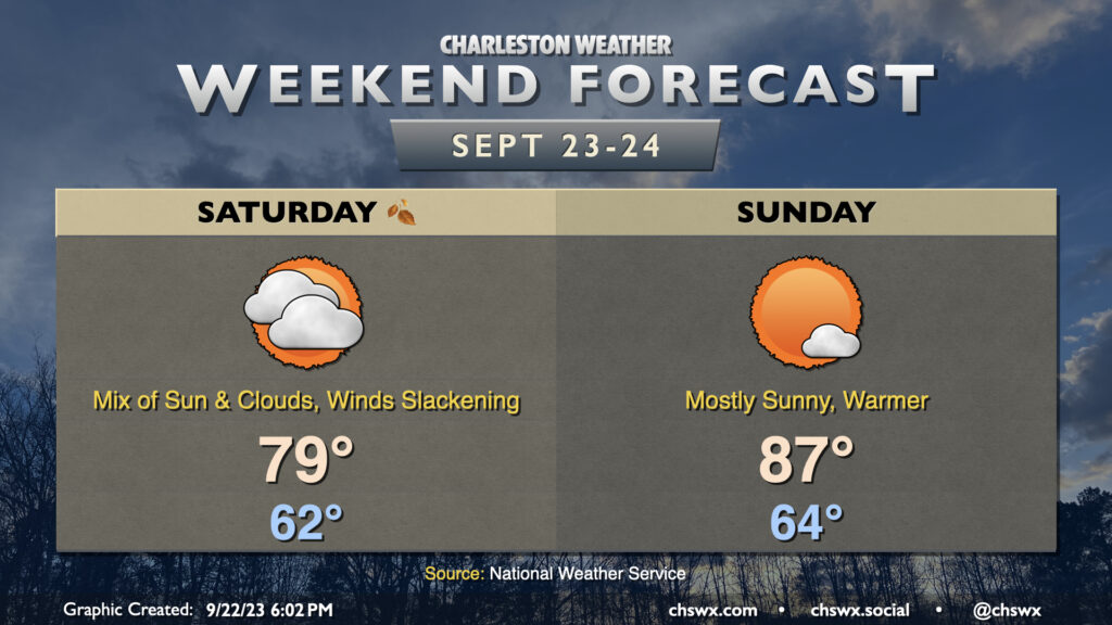
We’ll continue to deal with the fringes of Tropical Storm Ophelia on Saturday, though the weather will be gradually improving as time goes on. We’ll see a mix of sunshine and cloud cover, and northwest to westerly winds will still be a little elevated. However, as the day goes on and Ophelia moves further away, we’ll see those winds slacken and some of that cloud cover begin to break a little. The cooler and drier air wrapping around Ophelia will keep temperatures on the low side, with highs topping out in the upper 70s after a comfortable start in the low 60s.
Ophelia will have exited the weather picture on Sunday, and we’ll see much more sunshine and, overall, a warmer day as a result. Expect highs to top out in the mid-to-upper 80s after starting the day in the mid-60s. Winds will have backed down to generally light speeds, too, making for a nice day to get outside a bit. Try to take advantage, if you can!
Ophelia to make landfall overnight near the Outer Banks as a strong tropical storm
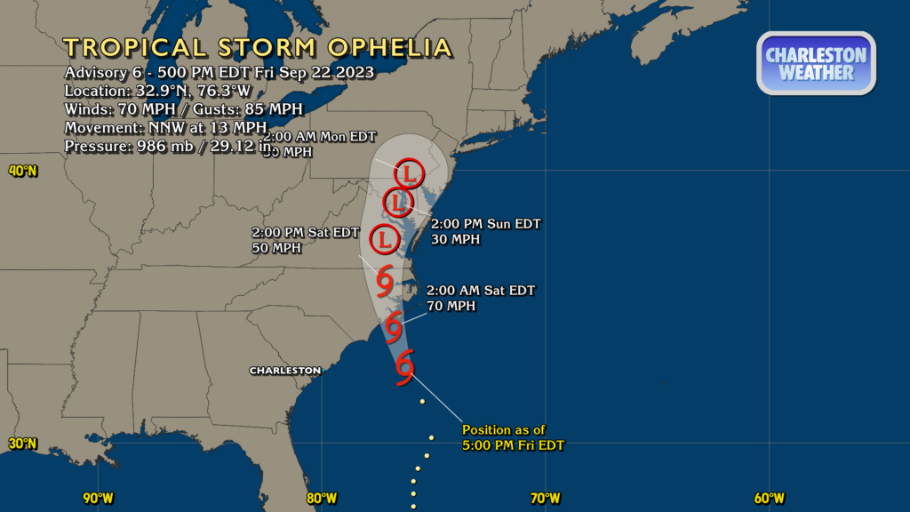
Tropical Storm Ophelia — the storm formerly known as Potential Tropical Cyclone Sixteen — will move into eastern North Carolina tonight as a fairly strong tropical storm, with maximum sustained winds of 70 MPH forecast by the National Hurricane Center. It’s not out of the question that it could briefly touch hurricane status, and as a result, a Hurricane Watch is up along parts of the North Carolina coast. Closer to home, Ophelia will continue to keep high surf around through tonight, and the risk for rip currents will remain elevated on Saturday. Expect improvements getting further into the weekend, though.

The only other area of real interest in the Atlantic is Invest 90L. It’s not the most organized clump of convection ever seen on satellite, but it should become a depression, likely by the end of the weekend. This will be a storm to watch for the Lesser Antilles, but early returns on the models remain consistent in turning this storm north well before it sniffs the East Coast of the United States. There’s plenty of time to watch it to ensure it does what it should do, and if it looks like it might be a little more newsworthy for us, I (and everyone else in the Charleston weather enterprise, for that matter) will sound the alarm. For now, though, no concerns here in the Lowcountry.
Follow my Charleston Weather updates on Mastodon, Bluesky, Instagram, Facebook, or directly in a feed reader. Do you like what you see here? Please consider supporting my independent, hype-averse weather journalism and become a supporter on Patreon for a broader look at all things #chswx!