Friday & the weekend: Cloud cover breaks, temperatures get warmer
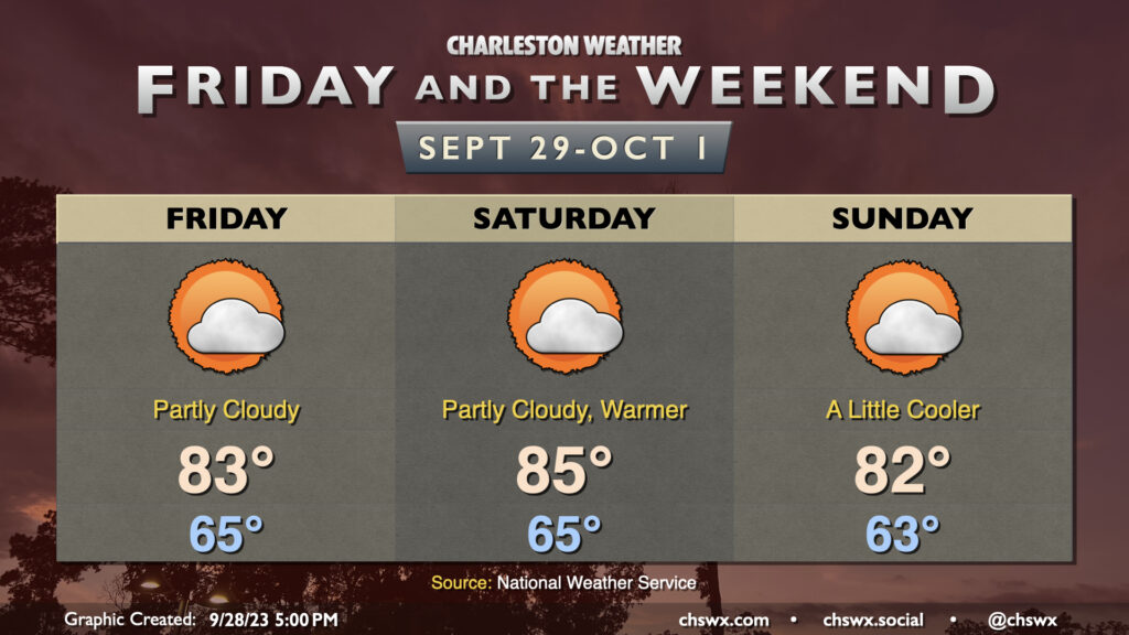
After a fairly cool and cloudy day on Thursday, cloud cover breaks up a bit for Friday into the weekend, and this will allow temperatures to return to the low to mid-80s each afternoon. Temperatures will peak Saturday before a little cooler air works into the area Sunday. Overall, it looks pretty good to get out and do stuff, especially with the northeasterly winds backing off a bit more as the pressure gradient relaxes.
Coastal flooding to continue through the weekend
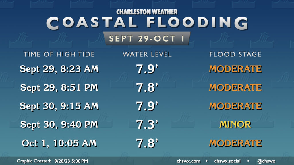
That’s not to say everything about this weekend’s weather is perfect, though. The full moon at perigee combined with continued northeasterly flow will keep tidal departures elevated, and as a result, coastal flooding will remain likely at times of high tide heading at least into Sunday. While the relaxing winds should help us stay out of major flood stage, it won’t be by much. Commute impacts appear likely once again Friday morning as water levels head toward around 7.9′ at high tide, which is expected to peak a little before 8:30am. If you’ve got Friday evening plans downtown, be ready to route around some tidal flooding as well as water levels peak around 7.8′ a little before 9pm. We’ll rinse and repeat with Saturday’s tides, though the evening high tide around 9:40pm should only produce minor flooding. Stay tuned to forecast updates and coastal flood alerts from the National Weather Service.
Tropics: Philippe and Rina get acquainted
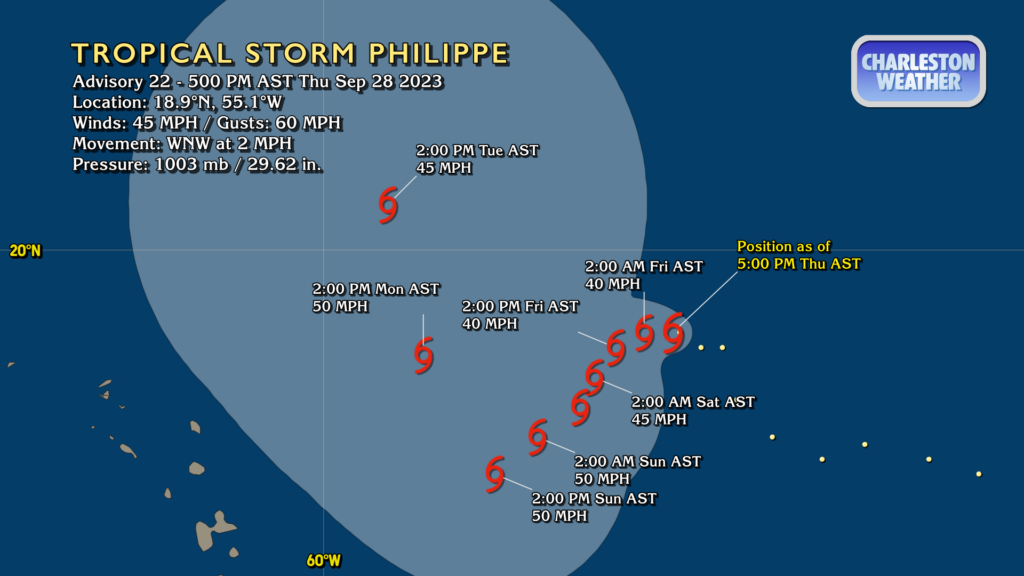
The tropics are getting weird, though not in any really scary way — just meteorologically interesting. Philippe and newly-christened Tropical Storm Rina will interact over the next few days, which casts a lot of uncertainty over both of their tracks. Philippe looks likely to head southwestward this weekend before high pressure to the north strengthens and pulls it northward…if it even survives that long thanks to shear from Rina. There’s a chance that Philippe’s motion (and Rina’s, for that matter) could be made rather erratic thanks to the Fujiwhara effect, which causes the storms to orbit a point between them.
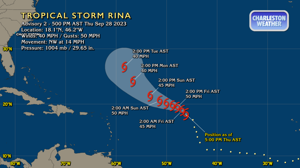
At first glance, Rina’s track seems relatively straightforward, and perhaps that will be the case, though if it interacts more with Philippe, it may become less cut and dry in the short term. It, too, could be weakened some by the interaction with Philippe, but the expectation is that it survives the interaction and eventually turns more north heading into next week as high pressure strengthens to the north. Weak systems can sometimes throw guidance for a loop, but all indications are that neither Rina nor Philippe pose any risk to the Lowcountry.
Elsewhere, there are no other areas of concern being monitored by the Hurricane Center.
Follow my Charleston Weather updates on Mastodon, Bluesky, Instagram, Facebook, or directly in a feed reader. Do you like what you see here? Please consider supporting my independent, hype-averse weather journalism and become a supporter on Patreon for a broader look at all things #chswx!