Rest of the work week: Still a little hazy Wednesday, then a front approaches
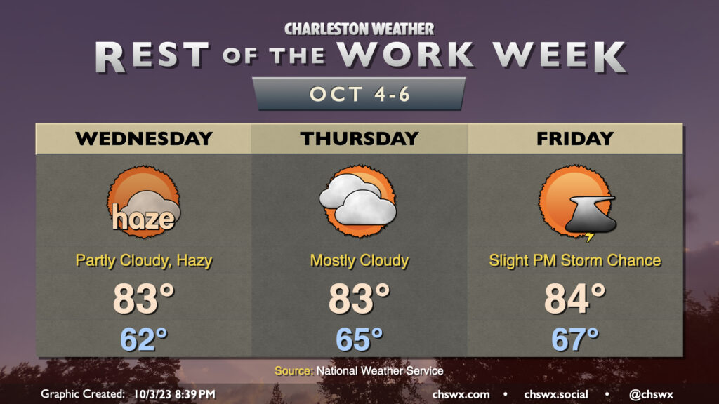
The past couple days have been marred somewhat by wildfire smoke moving southwest from Canada, and it looks like that may persist at least into parts of Wednesday as well. There could be some air quality impacts, so if you are sensitive to particulate matter, you may want to spend a little more time inside. (Masks such as N95s will help here, too!) Smoke aside, the weather is otherwise quiet; lows bottom out in the low 60s once again and head into the low 80s in the afternoon under partly cloudy skies. We’ll also need to keep an eye on the midday high tide for one more round of minor coastal flooding, but that should do it for this stretch of coastal flooding events with some pattern changes in the offing.
We should see improvements with the smoke heading into Thursday, but cloud cover will begin to creep up as a little more moisture starts to work into the area. We should stay rain-free, though a shower might not be totally out of bounds. Highs once again top out in the low-to-mid-80s.
Warmth peaks Friday as ever-so-slightly higher dewpoint air continues to move in. We start the day in the mid-to-upper 60s and top out in the mid-80s with a chance of a shower or thunderstorm or two in the afternoon ahead of an approaching cold front. Said front moves by Saturday, and by Sunday, temperatures are very fall-like.
Tropics: Philippe continues to confound, but remains a non-issue for the Lowcountry
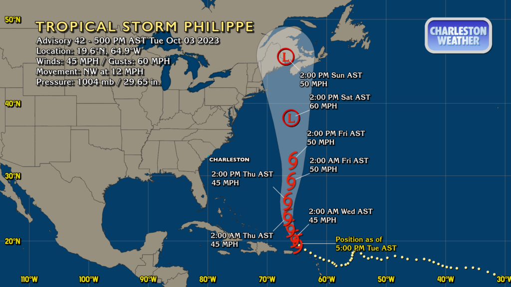
Philippe remains the main storm to watch in the Atlantic, but at the outset, it’s important to note that it doesn’t pose any concern for us here at home. However, that’s not to say the forecast hasn’t been somewhat frustrating at times, with model inconsistency a hallmark of this one (likely due to initialization struggles with a weaker storm). The meat of the latest NHC forecast remains unchanged from yesterday, though: Philippe will continue to move northwestward before turning more northerly on Wednesday heading into Thursday. A slightly northeastern motion is forecast, but it should turn a touch back more northerly as it passes north of our latitude at 32°N. The latest NHC forecast shows Philippe making extratropical transition over the weekend (the previous forecast was forecasting a hurricane) and perhaps making a run at Nova Scotia or even Maine.
Elsewhere, there are no tropical concerns in the rest of the Atlantic, much less the Lowcountry.
Heads up: FEMA Wireless Emergency Alerts test at 2:20 PM
Barring a last-minute change of plans, FEMA plans to perform a national test of the Emergency Alert System, including Wireless Emergency Alerts, around 2:20 PM Eastern Time on Wednesday. If all goes as it should, phones across the country will come alive with a cacophony of alert tones and incessant vibrations. There’s no actual emergency (well, I hope not, anyway) and you won’t need to do anything else.
If you or a loved one are in a situation where a concealed second phone is important to safety, it’s recommended to turn that phone off before the test tomorrow, and leave it off until the phone can be safely turned back on. The test will transmit periodically to ensure that all phones get it for roughly 30 minutes after the test begins, and so even if it is off at test time, turning it back on shortly thereafter will still trigger the alert, which is why it’s important to only turn it back on when it is safe from being discovered.
The next national Wireless Emergency Alerts test should take place by 2026, as they are federally mandated to happen at least once every three years.
Follow my Charleston Weather updates on Mastodon, Bluesky, Instagram, Facebook, or directly in a feed reader. Do you like what you see here? Please consider supporting my independent, hype-averse weather journalism and become a supporter on Patreon for a broader look at all things #chswx!