The week ahead: Chilly start, then turning unsettled
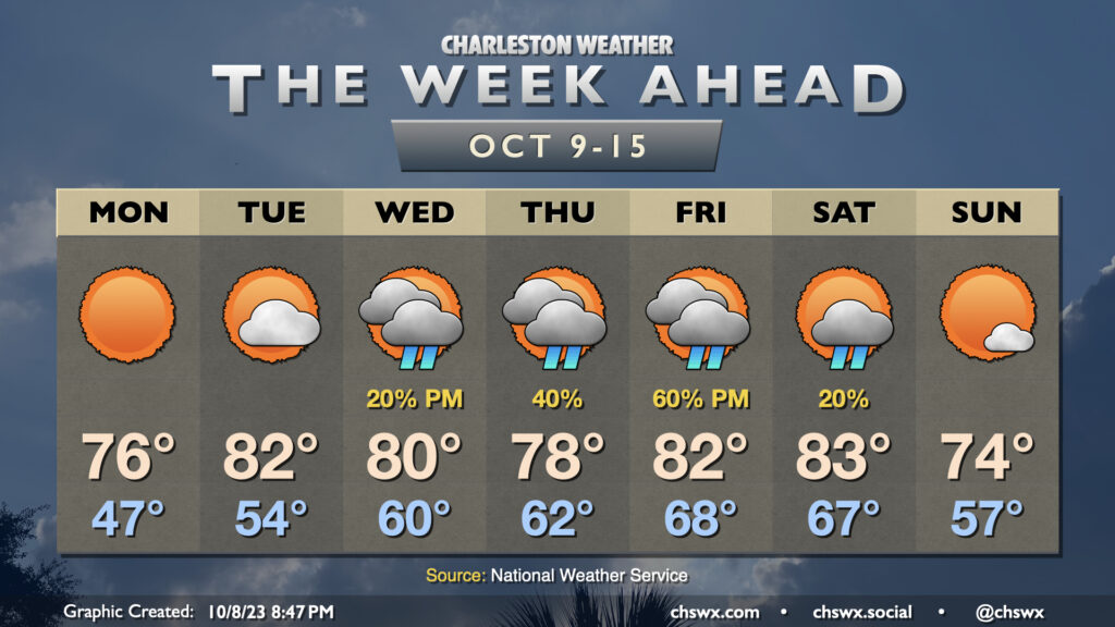
After a day that featured lows in the low 50s and highs topping out just in the low 70s, clear skies and calm winds will allow temperatures across much of the metro area (inland of the coast, anyway) to fall into the 40s for the first time since early May on Monday morning. Sunny skies will prevail throughout the day, and temperatures should reach the mid-70s in the afternoon as a result. Overall, it will be another really nice day across the Lowcountry.
The chill will gradually recede as high pressure shifts offshore during the day Monday. Tuesday will run warmer and a little cloudier, with highs topping out in the low 80s in the afternoon after a mid-50s start. A little more cloud cover works into the area by Wednesday as a jet streak strengthens overhead, which should lead to a few showers later in the day (though there’s a lot of dry air to overcome initially). Shower chances improve into Thursday as low pressure moves eastward out of the Gulf of Mexico. We should see an uptick in cloud cover and a little cooler day as well as high pressure wedges in from the northeast. We’ll stay wedged in for a good bit of Friday, though a warm front should lift northward later in the day. Shower chances will continue and perhaps tick up a bit as the aforementioned warm front gets nearby. A little thunder will be possible, too.
Conditions should gradually improve over the weekend as a cold front gets through late on Saturday, and by Sunday, temperatures head back below normal into the mid-70s under mostly sunny skies. (Frontal timing, of course, will be fine-tuned as the week goes on.)
Tropics: Not much to write home about
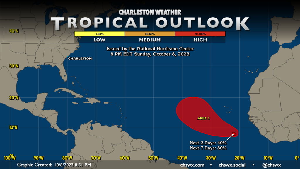
The tropics are mostly quiet. There are no active cyclones, and only one area of note in the Atlantic, tagged as Invest 92L, well south of the Cabo Verde Islands. This area has an 80% chance to develop into a depression this week. All indications are it stays way out there and doesn’t represent a threat to any land, much less the Lowcountry. Elsewhere, things remain quiet; we’ll keep an eye on anything that tries to get going closer to home, but right now that doesn’t look like an issue either.
Follow my Charleston Weather updates on Mastodon, Bluesky, Instagram, Facebook, or directly in a feed reader. Do you like what you see here? Please consider supporting my independent, hype-averse weather journalism and become a supporter on Patreon for a broader look at all things #chswx!