Rest of the work week: Generally quiet, but turning breezy

Another chilly start is in store for Wednesday as high pressure to our north keeps some cool air blowing into the area throughout the night. This will send temperatures down to the mid-30s once again, with another shot at freezing in a few more secluded spots. Wind chills will dip below 32° at times in the morning, so be sure to dress appropriately. The good news is that we warm up some compared to Tuesday, heading to the low 60s in the afternoon under partly cloudy skies.
The brief warmup doesn’t last long, though: a reinforcing cold front comes through overnight Wednesday into Thursday, ushering in strong high pressure that will not only reinforce the chill — expect highs just to top out in the mid-to-upper 50s — but also kick up the northeasterly winds, which will start to drive tidal departures higher as well, which may lead to minor to moderate coastal flooding in the morning. This strong high pressure will lead to another mid-30s start on Friday, with highs struggling to the upper 50s despite mostly sunny skies. We’ll also need to watch Friday morning’s tidal departures for the risk for additional coastal flooding.
Weekend outlook: Watching for the potential for a coastal storm
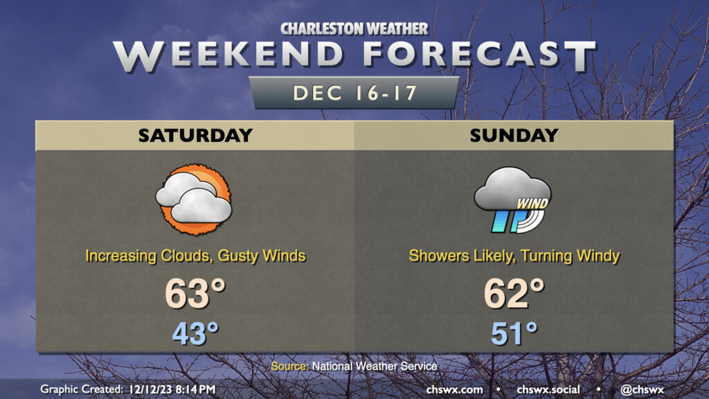
As we head toward the weekend, we’ll be watching for the potential for a coastal storm to take shape starting in the Gulf and then moving northward. Model guidance is quite aggressive with how much it wants to deepen the low, suggesting a fairly strong storm could develop. There remain significant questions on timing and track of the low, and that introduces quite a bit of uncertainty in the forecast. As it stands right now, we look to stay rain-free on Saturday with a little warmer air starting to move in. Winds will remain on the gusty side and clouds will gradually fill in as we head into Saturday evening, though. We could start feeling the storm in earnest overnight Saturday into Sunday as shower chances increase along with the winds. Some decent gusts will be possible, especially at the coast and over the coastal waters, where gales will be a forecast concern. It certainly appears that we’ll continue to contend with coastal flooding with at least the morning high tides, as well. Current thinking is that this storm continues to affect the area Monday into early Tuesday before departing to the north as a nor’easter.
Stay tuned to forecast updates throughout the week as trends become established and details are buttoned up as this storm has the potential to bring some pretty decent impacts to the area.
Follow my Charleston Weather updates on Mastodon, Bluesky, Instagram, Facebook, or directly in a feed reader. Do you like what you see here? Please consider supporting my independent, hype-averse weather journalism and become a supporter on Patreon for a broader look at all things #chswx!